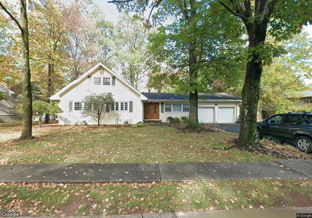
35 Huntington Rd Edison, NJ 08820
Estimated Value: $820,691 - $989,000
5
Beds
3
Baths
1,792
Sq Ft
$504/Sq Ft
Est. Value
About This Home
This home is located at 35 Huntington Rd, Edison, NJ 08820 and is currently estimated at $903,423, approximately $504 per square foot. 35 Huntington Rd is a home located in Middlesex County with nearby schools including Menlo Park Elementary School, Woodrow Wilson Middle School, and J.P. Stevens High School.
Ownership History
Date
Name
Owned For
Owner Type
Purchase Details
Closed on
Jul 22, 2008
Sold by
Kraft E Burton and Kraft Andrea D
Bought by
Limratanamongkol Paisan and Loetamonphong Jiranut
Current Estimated Value
Home Financials for this Owner
Home Financials are based on the most recent Mortgage that was taken out on this home.
Original Mortgage
$452,000
Outstanding Balance
$295,710
Interest Rate
6.35%
Mortgage Type
Purchase Money Mortgage
Estimated Equity
$607,713
Purchase Details
Closed on
Jul 24, 2002
Sold by
Sobel Lois
Bought by
Kraft Burton and Kraft Andrea
Home Financials for this Owner
Home Financials are based on the most recent Mortgage that was taken out on this home.
Original Mortgage
$300,000
Interest Rate
6.57%
Create a Home Valuation Report for This Property
The Home Valuation Report is an in-depth analysis detailing your home's value as well as a comparison with similar homes in the area
Home Values in the Area
Average Home Value in this Area
Purchase History
| Date | Buyer | Sale Price | Title Company |
|---|---|---|---|
| Limratanamongkol Paisan | $565,000 | Multiple | |
| Kraft Burton | $445,000 | -- |
Source: Public Records
Mortgage History
| Date | Status | Borrower | Loan Amount |
|---|---|---|---|
| Open | Limratanamongkol Paisan | $452,000 | |
| Previous Owner | Kraft Burton | $300,000 |
Source: Public Records
Tax History
| Year | Tax Paid | Tax Assessment Tax Assessment Total Assessment is a certain percentage of the fair market value that is determined by local assessors to be the total taxable value of land and additions on the property. | Land | Improvement |
|---|---|---|---|---|
| 2025 | $13,829 | $232,300 | $121,600 | $110,700 |
| 2024 | $13,754 | $232,300 | $121,600 | $110,700 |
Source: Public Records
Map
Nearby Homes
- 1868 Oak Tree Rd
- 48 Lynnwood Rd
- 1821 Oak Tree Rd
- 3 Hummingbird Ln
- 177 Mundy Ave
- 24 Norton St
- 354 Plainfield Rd
- 454 Plainfield Rd
- 496 Grove Ave
- 1123 New Dover Rd
- 1125 New Dover Rd
- 51 Adams St
- 265 Plainfield Rd
- 3996 Park Ave
- 21 Williams Rd
- 9 Links Dr
- 64 Richard Rd
- 4 David Ct
- 8 Stephenville Pkwy
- 12 Edgewood Rd
- 4 Midland Rd
- 33 Huntington Rd
- 34 Huntington Rd
- 36 Huntington Rd
- 110 Stephenville Pkwy
- 108 Stephenville Pkwy
- 31 Huntington Rd
- 32 Huntington Rd
- 112 Stephenville Pkwy
- 106 Stephenville Pkwy
- 10 Midland Rd
- 7 Midland Rd
- 29 Huntington Rd
- 4 Hadfield Rd
- 102 Stephenville Pkwy
- 114 Stephenville Pkwy
- 27 Huntington Rd
- 11 Midland Rd
- 12 Midland Rd
- 107 Stephenville Pkwy
Your Personal Tour Guide
Ask me questions while you tour the home.