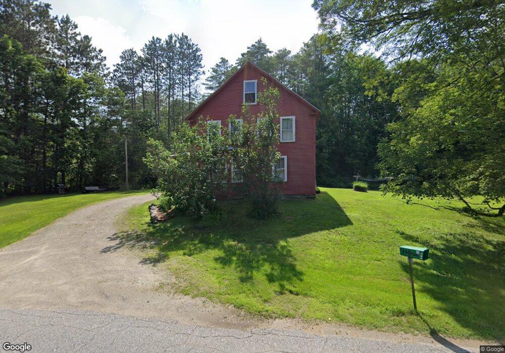
35 Old Newport Rd Marlow, NH 03456
Estimated Value: $352,517 - $386,000
4
Beds
2
Baths
2,054
Sq Ft
$180/Sq Ft
Est. Value
About This Home
This home is located at 35 Old Newport Rd, Marlow, NH 03456 and is currently estimated at $370,129, approximately $180 per square foot. 35 Old Newport Rd is a home with nearby schools including Candor Elementary School, Mayland Early College High School, and Keene High School.
Ownership History
Date
Name
Owned For
Owner Type
Purchase Details
Closed on
Aug 1, 2016
Sold by
Anreasen 3Rd Arthur E and Andreasen Mary C
Bought by
Anreasen Ft
Current Estimated Value
Purchase Details
Closed on
Apr 19, 2004
Sold by
Maclachlan Trevor I and Maclachlan Jane A
Bought by
Reyes Martin
Home Financials for this Owner
Home Financials are based on the most recent Mortgage that was taken out on this home.
Original Mortgage
$80,000
Interest Rate
5.58%
Mortgage Type
Purchase Money Mortgage
Create a Home Valuation Report for This Property
The Home Valuation Report is an in-depth analysis detailing your home's value as well as a comparison with similar homes in the area
Home Values in the Area
Average Home Value in this Area
Purchase History
| Date | Buyer | Sale Price | Title Company |
|---|---|---|---|
| Anreasen Ft | -- | -- | |
| Reyes Martin | $45,000 | -- |
Source: Public Records
Mortgage History
| Date | Status | Borrower | Loan Amount |
|---|---|---|---|
| Previous Owner | Reyes Martin | $80,000 |
Source: Public Records
Tax History Compared to Growth
Tax History
| Year | Tax Paid | Tax Assessment Tax Assessment Total Assessment is a certain percentage of the fair market value that is determined by local assessors to be the total taxable value of land and additions on the property. | Land | Improvement |
|---|---|---|---|---|
| 2024 | $5,958 | $192,200 | $63,700 | $128,500 |
| 2023 | $5,539 | $192,200 | $63,700 | $128,500 |
| 2022 | $4,965 | $192,200 | $63,700 | $128,500 |
| 2021 | $4,749 | $192,200 | $63,700 | $128,500 |
| 2020 | $6 | $192,200 | $63,700 | $128,500 |
| 2019 | $5,308 | $166,300 | $48,700 | $117,600 |
| 2018 | $4,229 | $166,300 | $48,700 | $117,600 |
| 2016 | $3,654 | $166,300 | $48,700 | $117,600 |
| 2015 | $4,256 | $166,300 | $48,700 | $117,600 |
| 2014 | $4,705 | $188,710 | $60,980 | $127,730 |
| 2009 | $4,307 | $200,770 | $66,470 | $134,300 |
Source: Public Records
Map
Nearby Homes
- 172 Nh-Rte 123 Route
- 6 Mill St
- 0 Washington Pond Rd Unit 113
- 67 Lang Rd
- 0 Adams Dr
- 335 Coolidge Dr
- 178 North Rd
- 286 Presidential Dr
- 27 Shadowland Rd
- 32 Blueberry Hill Ln
- 16 Nash Corner Rd
- 00 Scenic Dr Unit 22
- 00 Kennedy Brook Dr Unit 11
- 264 Olds Rd
- 116 Beaver Lake Dr
- 0 Olds Rd
- 114 Eva Ln
- 2167 Valley Rd
- 1018 Route 123 N
- 1025 Route 123 N
- 40 Old Marlow Hill
- 23 Old Newport Rd
- 51 Old Newport Rd
- 790 Nh Route 10 Unit 10
- 20 Old Newport Rd
- 53 Old Newport Rd
- 180 Forest Rd
- 200 Nh Route 123
- 180 Nh Route 123
- 190 Nh Route 123
- 174 Nh Route 123
- 174 Nh Route 123
- 174 Nh Rte 123
- 172 Nh Route 123
- 194 Nh Route 123
- 174 New Hampshire 123
- 20 Whyte Dr
- 170 Nh Route 123
- 166 Nh Route 123
- 170 Forest Rd