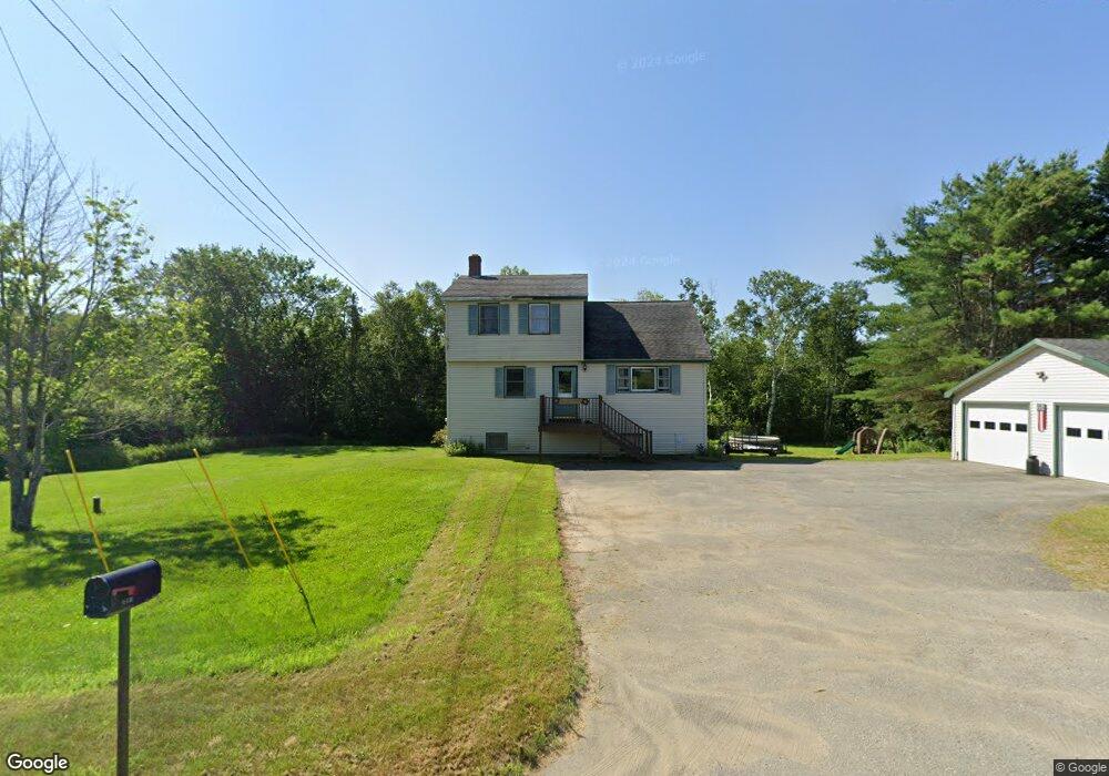
350 Stetson Rd W Levant, ME 04456
Estimated Value: $328,000 - $364,634
3
Beds
2
Baths
1,792
Sq Ft
$193/Sq Ft
Est. Value
About This Home
This home is located at 350 Stetson Rd W, Levant, ME 04456 and is currently estimated at $346,159, approximately $193 per square foot. 350 Stetson Rd W is a home located in Penobscot County with nearby schools including Suzanne M. Smith Elementary School and Caravel Middle School.
Ownership History
Date
Name
Owned For
Owner Type
Purchase Details
Closed on
Jun 12, 2020
Sold by
Dean Keith M
Bought by
Dean Amy J and Dean Keith M
Current Estimated Value
Home Financials for this Owner
Home Financials are based on the most recent Mortgage that was taken out on this home.
Original Mortgage
$137,500
Outstanding Balance
$121,883
Interest Rate
3.2%
Mortgage Type
Stand Alone Refi Refinance Of Original Loan
Estimated Equity
$224,276
Purchase Details
Closed on
Jun 18, 2009
Sold by
Mayhew Johnboy
Bought by
Dean Keith M
Home Financials for this Owner
Home Financials are based on the most recent Mortgage that was taken out on this home.
Original Mortgage
$145,408
Interest Rate
4.91%
Mortgage Type
FHA
Purchase Details
Closed on
Mar 19, 2009
Sold by
Bank Of America Na
Bought by
Mayhew Johnboy
Purchase Details
Closed on
Feb 6, 2009
Sold by
Savage Herbert L
Bought by
Bank Of America Na
Create a Home Valuation Report for This Property
The Home Valuation Report is an in-depth analysis detailing your home's value as well as a comparison with similar homes in the area
Home Values in the Area
Average Home Value in this Area
Purchase History
| Date | Buyer | Sale Price | Title Company |
|---|---|---|---|
| Dean Amy J | -- | None Available | |
| Dean Amy J | -- | None Available | |
| Dean Keith M | -- | -- | |
| Dean Keith M | -- | -- | |
| Mayhew Johnboy | -- | -- | |
| Mayhew Johnboy | -- | -- | |
| Bank Of America Na | -- | -- | |
| Bank Of America Na | -- | -- |
Source: Public Records
Mortgage History
| Date | Status | Borrower | Loan Amount |
|---|---|---|---|
| Open | Dean Amy J | $137,500 | |
| Closed | Dean Amy J | $137,500 | |
| Previous Owner | Bank Of America Na | $145,408 |
Source: Public Records
Tax History Compared to Growth
Tax History
| Year | Tax Paid | Tax Assessment Tax Assessment Total Assessment is a certain percentage of the fair market value that is determined by local assessors to be the total taxable value of land and additions on the property. | Land | Improvement |
|---|---|---|---|---|
| 2024 | $2,505 | $227,700 | $42,500 | $185,200 |
| 2023 | $2,476 | $210,700 | $42,500 | $168,200 |
| 2022 | $2,524 | $144,200 | $33,300 | $110,900 |
| 2021 | $2,524 | $144,200 | $33,300 | $110,900 |
| 2020 | $2,524 | $144,200 | $33,300 | $110,900 |
| 2019 | $2,163 | $144,200 | $33,300 | $110,900 |
| 2018 | $2,040 | $145,700 | $33,300 | $112,400 |
| 2017 | $1,829 | $135,500 | $33,300 | $102,200 |
| 2016 | $1,694 | $135,500 | $33,300 | $102,200 |
| 2015 | $1,694 | $135,500 | $33,300 | $102,200 |
| 2014 | $1,694 | $135,500 | $33,300 | $102,200 |
Source: Public Records
Map
Nearby Homes
- 61 Club House Rd
- 28 Levant Heights Dr
- 278 Merrill Rd
- 256 Merrill Rd
- 730 Village Rd
- 11 Sinclair Rd
- Lot 15-15 Brann Rd
- 189 Stetson Rd E
- 153 Stetson Rd E
- 168 Stetson Rd E
- 129 Maple Shore Ln
- 3-3-A Avenue Rd
- Lot 15-15 Stetson Rd E
- 40 Birch Way
- 81 Robichaud Rd
- 144 Loon Cove
- 24 Robichaud Rd
- # S Levant Rd
- 965 Mount Pleasant Rd
- 3935 Union St
- 356 Stetson Rd W
- 357 Stetson Rd W
- 340 Stetson Rd W
- 382 Stetson Rd W
- 382 Stetson Rd (Rt 222)
- 371 Stetson Rd W
- 374 Stetson Rd W
- 327 Stetson Rd W
- 21 Doughty Blvd
- Lot 27A Doughty Blvd
- 0 Doughty Ave
- LOT 6 McIntosh and Doughty
- 6 McIntosh Drive & Doughty Ave
- 6 Mcintosh Ave
- 381 Stetson Rd W
- 6 Mcintosh Ave
- 6 Mcintosh Ave
- 6 Mcintosh Ave
- 16 Mcintosh Ave
- 12 Mcintosh Ave