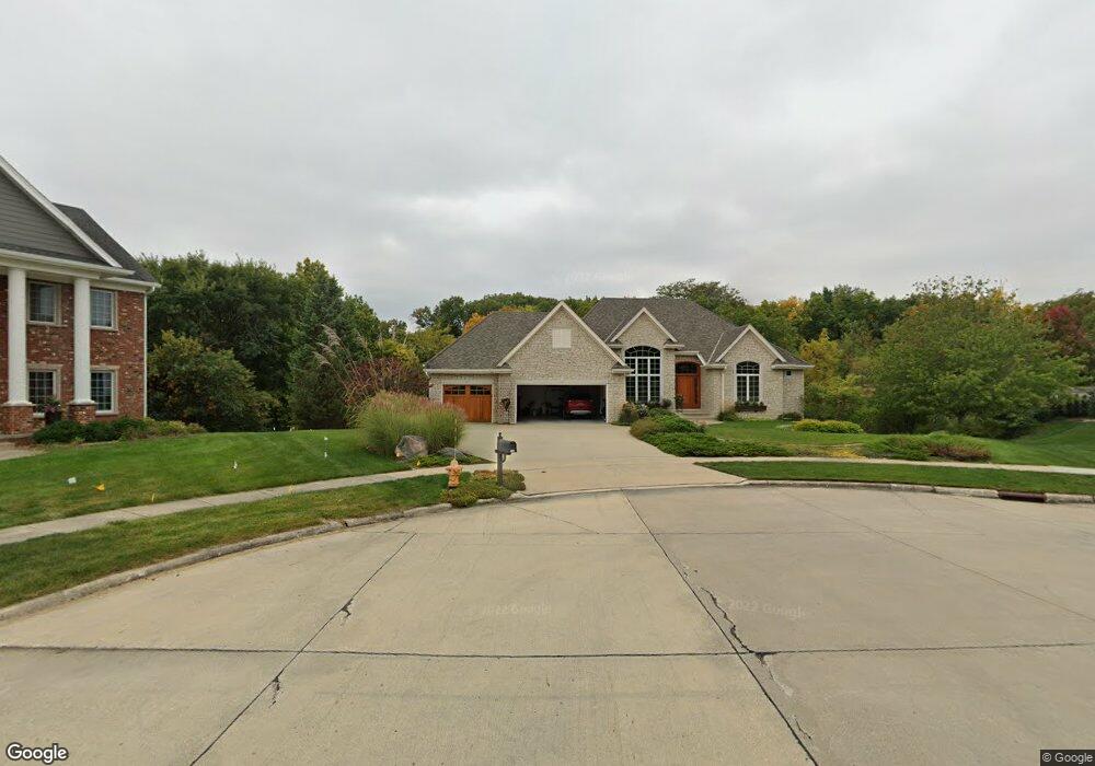
3506 132nd Ct Urbandale, IA 50323
Estimated Value: $578,000 - $889,000
2
Beds
4
Baths
2,460
Sq Ft
$311/Sq Ft
Est. Value
About This Home
This home is located at 3506 132nd Ct, Urbandale, IA 50323 and is currently estimated at $764,476, approximately $310 per square foot. 3506 132nd Ct is a home located in Polk County with nearby schools including Webster Elementary School, Urbandale Middle School, and Urbandale High School.
Ownership History
Date
Name
Owned For
Owner Type
Purchase Details
Closed on
Jun 26, 2023
Sold by
Klaus Steven J and Klaus Sharon L
Bought by
Steve And Sharon Klaus Joint Revocable Trust
Current Estimated Value
Purchase Details
Closed on
Oct 11, 2001
Sold by
Harrington Homes Ltd
Bought by
Klaus Steven James and Klaus Sharon Louise
Home Financials for this Owner
Home Financials are based on the most recent Mortgage that was taken out on this home.
Original Mortgage
$128,000
Interest Rate
6.99%
Purchase Details
Closed on
Jan 20, 2000
Sold by
Knapp & Associates Ltd Partnership
Bought by
Harrington Homes & Assoc Ltd
Home Financials for this Owner
Home Financials are based on the most recent Mortgage that was taken out on this home.
Original Mortgage
$96,000
Interest Rate
7.84%
Mortgage Type
Credit Line Revolving
Create a Home Valuation Report for This Property
The Home Valuation Report is an in-depth analysis detailing your home's value as well as a comparison with similar homes in the area
Home Values in the Area
Average Home Value in this Area
Purchase History
| Date | Buyer | Sale Price | Title Company |
|---|---|---|---|
| Steve And Sharon Klaus Joint Revocable Trust | -- | None Listed On Document | |
| Klaus Steven James | $131,000 | -- | |
| Harrington Homes & Assoc Ltd | $224,500 | -- |
Source: Public Records
Mortgage History
| Date | Status | Borrower | Loan Amount |
|---|---|---|---|
| Previous Owner | Klaus Steven James | $128,000 | |
| Previous Owner | Harrington Homes & Assoc Ltd | $96,000 | |
| Closed | Harrington Homes & Assoc Ltd | $366,000 |
Source: Public Records
Tax History Compared to Growth
Tax History
| Year | Tax Paid | Tax Assessment Tax Assessment Total Assessment is a certain percentage of the fair market value that is determined by local assessors to be the total taxable value of land and additions on the property. | Land | Improvement |
|---|---|---|---|---|
| 2025 | $13,856 | $880,700 | $184,500 | $696,200 |
| 2024 | $13,856 | $791,100 | $163,800 | $627,300 |
| 2023 | $13,104 | $791,100 | $163,800 | $627,300 |
| 2022 | $12,950 | $623,000 | $134,000 | $489,000 |
| 2021 | $13,956 | $623,000 | $134,000 | $489,000 |
| 2020 | $13,716 | $636,500 | $137,000 | $499,500 |
| 2019 | $14,082 | $636,500 | $137,000 | $499,500 |
| 2018 | $13,582 | $614,800 | $129,900 | $484,900 |
| 2017 | $13,926 | $614,800 | $129,900 | $484,900 |
| 2016 | $13,594 | $618,100 | $110,700 | $507,400 |
| 2015 | $13,594 | $618,100 | $110,700 | $507,400 |
| 2014 | $12,724 | $596,100 | $105,200 | $490,900 |
Source: Public Records
Map
Nearby Homes
- 13282 Oak Brook Dr
- 12993 Oak Brook Dr
- 12926 Timberline Dr
- 13425 Ridgeview Dr
- 14130 Wilden Dr
- 14134 Wilden Dr
- 14136 Wilden Dr
- 13208 Rocklyn Dr
- 13504 Sheridan Ave
- 14111 Oak Brook Dr
- 13165 Pinecrest Ln
- 2216 NW 136th St
- 3837 NW 183rd St
- 12723 Sunflower Dr
- 3943 NW 181st St
- 4010 NW 181st St
- 3997 NW 181st St
- 12614 Ridgeview Dr
- 2094 NW 137th St
- 4111 140th St
- 3505 132nd Ct
- 3512 132nd Ct
- 3511 132nd Ct
- 13206 Beechwood Dr
- 3509 133rd Way
- 3515 133rd Way
- 2996 133rd Way
- 2990 133rd Way
- 3521 133rd Way
- 3503 133rd Way
- 13118 Beechwood Dr
- 13525 Oak Brook Dr
- 3504 131st St
- 13211 Beechwood Dr
- 3510 131st St
- 13205 Beechwood Dr
- 2976 133rd Way
- 13121 Beechwood Dr
- 13217 Beechwood Dr
- 3522 133rd Way