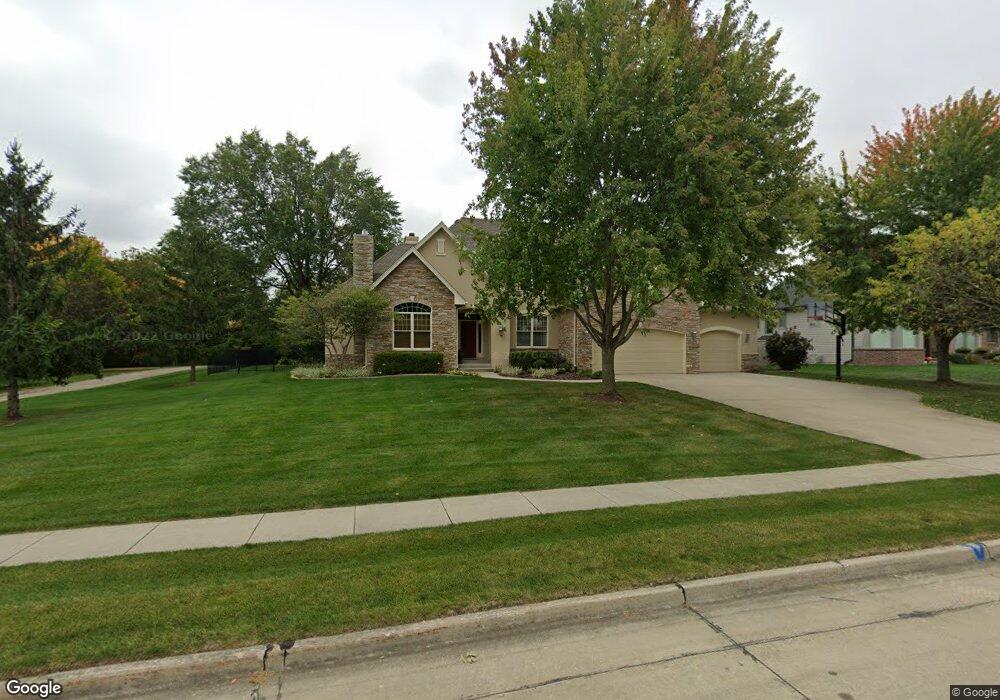
3523 131st St Urbandale, IA 50323
Estimated Value: $697,000 - $919,566
4
Beds
5
Baths
3,275
Sq Ft
$245/Sq Ft
Est. Value
About This Home
This home is located at 3523 131st St, Urbandale, IA 50323 and is currently estimated at $801,392, approximately $244 per square foot. 3523 131st St is a home located in Polk County with nearby schools including Webster Elementary School, Urbandale Middle School, and Urbandale High School.
Ownership History
Date
Name
Owned For
Owner Type
Purchase Details
Closed on
Jul 30, 2024
Sold by
Minor Christoph F and Minor Christopher F
Bought by
Christoph And Cheryl Minor Revocable Trust and Minor
Current Estimated Value
Purchase Details
Closed on
Jul 20, 2001
Sold by
Mcilhon Meri Jo and Mcilhon Edward J
Bought by
Minor Christopher F and Minor Cheryl R
Purchase Details
Closed on
Apr 1, 1999
Sold by
Timberline Development Lc
Bought by
Mcilhon Merijo
Create a Home Valuation Report for This Property
The Home Valuation Report is an in-depth analysis detailing your home's value as well as a comparison with similar homes in the area
Home Values in the Area
Average Home Value in this Area
Purchase History
| Date | Buyer | Sale Price | Title Company |
|---|---|---|---|
| Christoph And Cheryl Minor Revocable Trust | -- | None Listed On Document | |
| Minor Christopher F | $108,000 | -- | |
| Mcilhon Merijo | $104,500 | -- |
Source: Public Records
Tax History Compared to Growth
Tax History
| Year | Tax Paid | Tax Assessment Tax Assessment Total Assessment is a certain percentage of the fair market value that is determined by local assessors to be the total taxable value of land and additions on the property. | Land | Improvement |
|---|---|---|---|---|
| 2025 | $13,488 | $840,800 | $161,300 | $679,500 |
| 2024 | $13,488 | $755,200 | $143,200 | $612,000 |
| 2023 | $12,534 | $755,200 | $143,200 | $612,000 |
| 2022 | $12,388 | $593,000 | $117,200 | $475,800 |
| 2021 | $13,524 | $593,000 | $117,200 | $475,800 |
| 2020 | $13,292 | $613,900 | $119,800 | $494,100 |
| 2019 | $13,680 | $613,900 | $119,800 | $494,100 |
| 2018 | $13,196 | $594,300 | $113,600 | $480,700 |
| 2017 | $12,794 | $594,300 | $113,600 | $480,700 |
| 2016 | $12,488 | $565,500 | $106,500 | $459,000 |
| 2015 | $12,488 | $565,500 | $106,500 | $459,000 |
| 2014 | $12,196 | $547,000 | $101,200 | $445,800 |
Source: Public Records
Map
Nearby Homes
- 12993 Oak Brook Dr
- 12926 Timberline Dr
- 13282 Oak Brook Dr
- 13425 Ridgeview Dr
- 13208 Rocklyn Dr
- 13504 Sheridan Ave
- 14130 Wilden Dr
- 14134 Wilden Dr
- 14136 Wilden Dr
- 12614 Ridgeview Dr
- 12723 Sunflower Dr
- 13165 Pinecrest Ln
- 3837 NW 183rd St
- 14111 Oak Brook Dr
- 2216 NW 136th St
- 12324 Sunflower Dr
- 4016 127th St
- 12527 Airline Ave
- 12515 Airline Ave
- 12202 Madison Ave
- 3517 131st St
- 3607 131st St
- 3511 131st St
- 3527 131st St
- 3606 131st St
- 3615 131st St
- 13106 Beechwood Dr
- 13102 Timberline Dr
- 3510 131st St
- 3505 131st St
- 13109 Beechwood Dr
- 3621 131st St
- 3504 131st St
- 13108 Timberline Dr
- 13112 Timberline Dr
- 2983 132nd Ct
- 13115 Beechwood Dr
- 3703 131st St
- 2988 132nd Ct
- 13118 Beechwood Dr