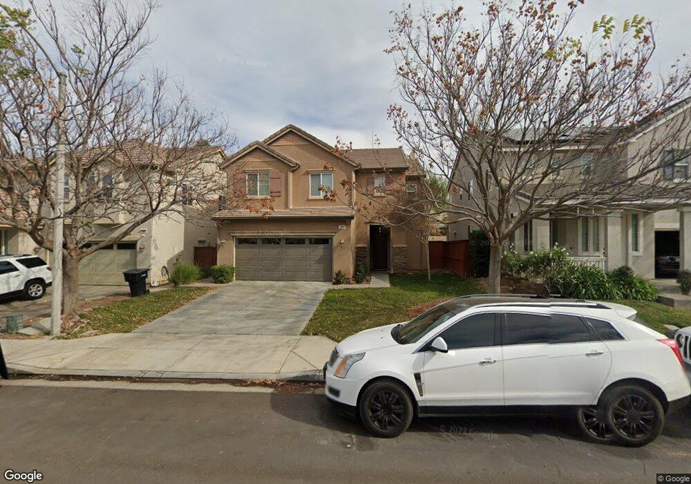
3553 Whieldon Dr Perris, CA 92571
North Perris NeighborhoodEstimated Value: $536,539 - $557,000
4
Beds
3
Baths
2,445
Sq Ft
$224/Sq Ft
Est. Value
About This Home
This home is located at 3553 Whieldon Dr, Perris, CA 92571 and is currently estimated at $548,135, approximately $224 per square foot. 3553 Whieldon Dr is a home located in Riverside County with nearby schools including Avalon Elementary School, Lakeside Middle School, and Rancho Verde High School.
Ownership History
Date
Name
Owned For
Owner Type
Purchase Details
Closed on
Aug 8, 2005
Sold by
Pulte Home Corp
Bought by
Bellason Reynaldo O and Bellason Raquel N
Current Estimated Value
Home Financials for this Owner
Home Financials are based on the most recent Mortgage that was taken out on this home.
Original Mortgage
$273,896
Outstanding Balance
$143,419
Interest Rate
5.61%
Mortgage Type
Fannie Mae Freddie Mac
Estimated Equity
$404,716
Create a Home Valuation Report for This Property
The Home Valuation Report is an in-depth analysis detailing your home's value as well as a comparison with similar homes in the area
Home Values in the Area
Average Home Value in this Area
Purchase History
| Date | Buyer | Sale Price | Title Company |
|---|---|---|---|
| Bellason Reynaldo O | $342,500 | Chicago Title |
Source: Public Records
Mortgage History
| Date | Status | Borrower | Loan Amount |
|---|---|---|---|
| Open | Bellason Reynaldo O | $273,896 |
Source: Public Records
Tax History
| Year | Tax Paid | Tax Assessment Tax Assessment Total Assessment is a certain percentage of the fair market value that is determined by local assessors to be the total taxable value of land and additions on the property. | Land | Improvement |
|---|---|---|---|---|
| 2025 | $7,419 | $468,031 | $95,647 | $372,384 |
| 2023 | $7,419 | $449,859 | $91,934 | $357,925 |
| 2022 | $7,199 | $441,039 | $90,132 | $350,907 |
| 2021 | $6,630 | $394,716 | $80,383 | $314,333 |
| 2020 | $6,115 | $352,424 | $71,770 | $280,654 |
| 2019 | $5,796 | $342,160 | $69,680 | $272,480 |
| 2018 | $5,643 | $329,000 | $67,000 | $262,000 |
| 2017 | $5,284 | $300,000 | $61,000 | $239,000 |
| 2016 | $5,101 | $283,000 | $58,000 | $225,000 |
| 2015 | $4,865 | $263,000 | $54,000 | $209,000 |
| 2014 | $4,880 | $263,000 | $54,000 | $209,000 |
Source: Public Records
Map
Nearby Homes
- 3577 Whieldon Dr
- 1910 Mount Verdugo Ln
- 3613 Whieldon Dr
- 3968 Coral Haven Ct
- 1752 Dennison Dr
- 1752 Campanella Dr
- 3374 Wind Chime Ln
- 1626 Queen Palm Ct
- 3860 Bella Isola Ln
- 27366 Dunite Dr
- 27330 Dunite Dr
- 27354 Dunite Dr
- 27318 Dunite Dr
- 27379 Dunite Dr
- 27365 Dunite Dr
- 27329 Dunite Dr
- 27353 Dunite Dr
- 27341 Dunite Dr
- 27279 Fossil Cove
- 3653 Alhambra Ln
- 3541 Whieldon Dr
- 3565 Whieldon Dr
- 3529 Whieldon Dr
- 3589 Whieldon Dr
- 3517 Whieldon Dr
- 3548 Whieldon Dr
- 3560 Whieldon Dr
- 3536 Whieldon Dr
- 3601 Whieldon Dr
- 3505 Whieldon Dr
- 3584 Whieldon Dr
- 3572 Whieldon Dr
- 3524 Whieldon Dr
- 3596 Whieldon Dr
- 3493 Whieldon Dr
- 3512 Whieldon Dr
- 3608 Whieldon Dr
- 3500 Whieldon Dr
- 3595 Chatsworth Way
- 3625 Whieldon Dr
Your Personal Tour Guide
Ask me questions while you tour the home.