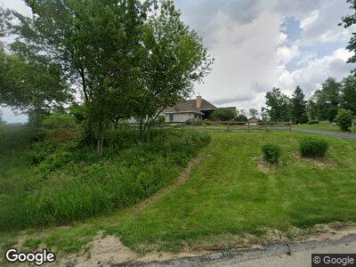
358 Abbotsford Rd Cedar Rapids, IA 52403
Estimated Value: $492,000 - $847,936
3
Beds
5
Baths
2,907
Sq Ft
$248/Sq Ft
Est. Value
About This Home
This home is located at 358 Abbotsford Rd, Cedar Rapids, IA 52403 and is currently estimated at $719,645, approximately $247 per square foot. 358 Abbotsford Rd is a home located in Linn County with nearby schools including Wilkins Elementary School, Excelsior Middle School, and Linn-Mar High School.
Ownership History
Date
Name
Owned For
Owner Type
Purchase Details
Closed on
Mar 28, 2022
Sold by
Ochs Barbara M
Bought by
Thomas E Pitlik Living Trust
Current Estimated Value
Purchase Details
Closed on
Nov 17, 2018
Sold by
Ochs Barbara M and Dieter Ochs H
Bought by
Ochs Barbara M
Create a Home Valuation Report for This Property
The Home Valuation Report is an in-depth analysis detailing your home's value as well as a comparison with similar homes in the area
Home Values in the Area
Average Home Value in this Area
Purchase History
| Date | Buyer | Sale Price | Title Company |
|---|---|---|---|
| Thomas E Pitlik Living Trust | $752,000 | None Listed On Document |
Source: Public Records
Mortgage History
| Date | Status | Borrower | Loan Amount |
|---|---|---|---|
| Open | Thomas E Pitlik Living Trust | $550,000 | |
| Closed | Thomas E Pitlick Living Trust | $400,000 | |
| Previous Owner | Ochs Baerbel M | $300,000 |
Source: Public Records
Tax History Compared to Growth
Tax History
| Year | Tax Paid | Tax Assessment Tax Assessment Total Assessment is a certain percentage of the fair market value that is determined by local assessors to be the total taxable value of land and additions on the property. | Land | Improvement |
|---|---|---|---|---|
| 2023 | $10,538 | $725,200 | $137,900 | $587,300 |
| 2022 | $10,008 | $671,000 | $137,900 | $533,100 |
| 2021 | $10,352 | $671,000 | $137,900 | $533,100 |
| 2020 | $10,352 | $646,900 | $137,900 | $509,000 |
| 2019 | $9,746 | $610,800 | $137,900 | $472,900 |
| 2018 | $9,308 | $610,800 | $137,900 | $472,900 |
| 2017 | $9,053 | $581,100 | $137,900 | $443,200 |
| 2016 | $9,053 | $581,100 | $137,900 | $443,200 |
| 2015 | $9,123 | $581,100 | $137,900 | $443,200 |
| 2014 | $8,986 | $581,100 | $137,900 | $443,200 |
| 2013 | $8,628 | $581,100 | $137,900 | $443,200 |
Source: Public Records
Map
Nearby Homes
- 503 Wanatee Creek Cir
- 2511 Deer Lane Rd
- 1810 Timber Wolf Trail SE
- 5638 Meadow Grass Cir SE
- 1900 Timber Wolf Trail SE
- Lot 9 Wild Rye Ct
- 5658 Meadow Grass Cir SE
- 5659 Wild Rye Ct SE
- Lot 10 Wild Rye Ct SE
- 1509 Aspen Cir SE
- 2215 Timber Wolf Trail SE
- 1209 Rose St
- Lot 3 Broadway & Wilder Dr SE
- Lot 2 Broadway & Wilder Dr SE
- 6930 Hackberry Loop
- 73 Pumpkin Patch Blvd
- 72 Pumpkin Patch Blvd
- 66 Pumpkin Patch Blvd
- 65 Pumpkin Patch Blvd
- 53 Bottom Land Ln
- 358 Abbotsford Rd
- 383 Abbotsford Rd
- 365 Abbotsford Rd
- 310 Abbotsford Rd
- 345 Innes Way
- 6630 Country Creek Ln
- 293 Haggis Way
- Lot 1 Country Creek Ln
- 6835 Lakeside Rd
- 449 Dows Rd
- 353 Squaw Ridge Rd
- 276 Abbotsford Rd
- 325 Innes Way
- 275 Haggis Way
- 464 Dows Rd
- 272 Haggis Way
- 6445 Country Creek Ln
- 258 Abbotsford Rd
- 505 Dows Rd
- 510 Dows Rd
