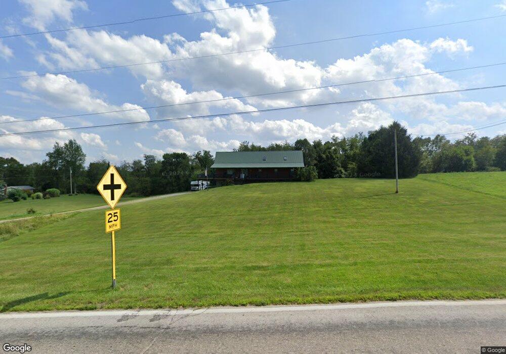
359 State Route 95 Loudonville, OH 44842
Estimated Value: $370,127 - $418,000
3
Beds
2
Baths
2,296
Sq Ft
$171/Sq Ft
Est. Value
About This Home
This home is located at 359 State Route 95, Loudonville, OH 44842 and is currently estimated at $392,532, approximately $170 per square foot. 359 State Route 95 is a home located in Ashland County with nearby schools including Hillsdale Elementary School, Hillsdale Middle School, and Hillsdale High School.
Ownership History
Date
Name
Owned For
Owner Type
Purchase Details
Closed on
Dec 21, 2018
Sold by
Hyatt Kevin S and Hyatt Brandi L
Bought by
Hatfield Larry
Current Estimated Value
Home Financials for this Owner
Home Financials are based on the most recent Mortgage that was taken out on this home.
Original Mortgage
$194,750
Outstanding Balance
$171,819
Interest Rate
4.87%
Mortgage Type
New Conventional
Estimated Equity
$220,713
Purchase Details
Closed on
Feb 23, 1999
Sold by
Mitchell George T
Bought by
Badertscher Rodney J
Purchase Details
Closed on
Nov 21, 1997
Sold by
Dyke Joel A
Bought by
Mitchell George T
Purchase Details
Closed on
Sep 6, 1995
Bought by
Dyke Joel A
Create a Home Valuation Report for This Property
The Home Valuation Report is an in-depth analysis detailing your home's value as well as a comparison with similar homes in the area
Home Values in the Area
Average Home Value in this Area
Purchase History
| Date | Buyer | Sale Price | Title Company |
|---|---|---|---|
| Hatfield Larry | $205,100 | Southern Title | |
| Badertscher Rodney J | $23,000 | -- | |
| Mitchell George T | $17,500 | -- | |
| Dyke Joel A | $7,500 | -- |
Source: Public Records
Mortgage History
| Date | Status | Borrower | Loan Amount |
|---|---|---|---|
| Open | Hatfield Larry | $194,750 |
Source: Public Records
Tax History Compared to Growth
Tax History
| Year | Tax Paid | Tax Assessment Tax Assessment Total Assessment is a certain percentage of the fair market value that is determined by local assessors to be the total taxable value of land and additions on the property. | Land | Improvement |
|---|---|---|---|---|
| 2024 | $3,187 | $92,860 | $17,570 | $75,290 |
| 2023 | $3,187 | $92,860 | $17,570 | $75,290 |
| 2022 | $2,900 | $66,330 | $12,550 | $53,780 |
| 2021 | $2,905 | $66,330 | $12,550 | $53,780 |
| 2020 | $2,729 | $66,330 | $12,550 | $53,780 |
| 2019 | $2,740 | $65,320 | $11,690 | $53,630 |
| 2018 | $2,660 | $65,320 | $11,690 | $53,630 |
| 2017 | $2,407 | $65,320 | $11,690 | $53,630 |
| 2016 | $2,407 | $59,390 | $10,630 | $48,760 |
| 2015 | $2,377 | $59,390 | $10,630 | $48,760 |
| 2013 | $2,908 | $65,250 | $10,600 | $54,650 |
Source: Public Records
Map
Nearby Homes
- 560 Township Road 2402
- 2057 State Route 89
- 112 Ohio 95
- 0 Ashland County Road 2175
- 0 Ashland County Road 2175
- 609 Ohio 95
- 150 E Main St
- 14 E South St
- 1845 County Road 655
- 2818 Township Road 2812
- 820 County Road 30a
- 7241 S Funk Rd
- 0 Township Road 925
- 1406 Pearl Dr
- 500 Stone Meadow Cir
- 518 Snyder Dr
- 723 Pearl Dr
- 524 N Union St
- 526 E Campbell St
- 359 State Route 95
- 359 State Route 95
- 359 State Route 95
- 359 Ohio 95
- 359 St Rte 95
- 351 State Route 95
- 351 Ohio 95
- 346 State Route 95
- 348 State Route 95
- 382 State Route 95
- 394 State Route 95
- 374 State Route 95
- 346 State Route 95
- 350 State Route 95
- 374 State Route 95
- 374 State Route 95
- 374 State Route 95
- 374 State Route 95
- 2294 County Road 377
- 350 Ohio 95