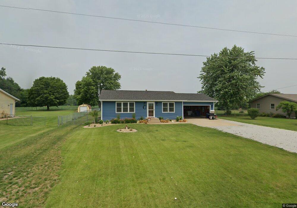
3599 E 300 S La Porte, IN 46350
Estimated Value: $223,000 - $259,000
3
Beds
1
Bath
1,008
Sq Ft
$237/Sq Ft
Est. Value
About This Home
This home is located at 3599 E 300 S, La Porte, IN 46350 and is currently estimated at $239,332, approximately $237 per square foot. 3599 E 300 S is a home located in LaPorte County with nearby schools including Indian Trail Elementary School, La Porte High School, and Dunkerton High School.
Ownership History
Date
Name
Owned For
Owner Type
Purchase Details
Closed on
Jul 1, 2021
Sold by
Griffin Jason
Bought by
Griffin Jason and Olson Shannon
Current Estimated Value
Purchase Details
Closed on
Jul 28, 2010
Sold by
Griffin Christine and Korepanow Christine R
Bought by
Griffin Jason
Purchase Details
Closed on
Mar 12, 2007
Sold by
Russell Douglas J
Bought by
Korepanow Christine R
Home Financials for this Owner
Home Financials are based on the most recent Mortgage that was taken out on this home.
Original Mortgage
$111,500
Outstanding Balance
$68,005
Interest Rate
6.4%
Mortgage Type
Unknown
Estimated Equity
$171,327
Create a Home Valuation Report for This Property
The Home Valuation Report is an in-depth analysis detailing your home's value as well as a comparison with similar homes in the area
Home Values in the Area
Average Home Value in this Area
Purchase History
| Date | Buyer | Sale Price | Title Company |
|---|---|---|---|
| Griffin Jason | -- | None Available | |
| Griffin Jason | -- | None Available | |
| Korepanow Christine R | -- | Meridian Title Corp |
Source: Public Records
Mortgage History
| Date | Status | Borrower | Loan Amount |
|---|---|---|---|
| Open | Korepanow Christine R | $111,500 |
Source: Public Records
Tax History Compared to Growth
Tax History
| Year | Tax Paid | Tax Assessment Tax Assessment Total Assessment is a certain percentage of the fair market value that is determined by local assessors to be the total taxable value of land and additions on the property. | Land | Improvement |
|---|---|---|---|---|
| 2024 | $1,664 | $172,500 | $30,600 | $141,900 |
| 2023 | $1,585 | $171,600 | $30,600 | $141,000 |
| 2022 | $1,479 | $156,300 | $30,600 | $125,700 |
| 2021 | $1,172 | $133,700 | $30,600 | $103,100 |
| 2020 | $1,085 | $133,700 | $30,600 | $103,100 |
| 2019 | $1,149 | $130,500 | $30,600 | $99,900 |
| 2018 | $843 | $109,100 | $20,000 | $89,100 |
| 2017 | $771 | $104,000 | $20,000 | $84,000 |
| 2016 | $865 | $112,800 | $20,000 | $92,800 |
| 2014 | $796 | $113,300 | $20,000 | $93,300 |
Source: Public Records
Map
Nearby Homes
- 0 E State Road 4
- 3466 S State Road 104
- 2208 E 450 S
- 3961 State Road 104
- 6152 E State Road 4
- 1168 E State Road 4
- 345 S 600 E
- 315 Holly Dr
- 7237 E 370 S
- 0 Cherry Dr
- 0 S Longshore Dr
- 0 N Fail Rd Unit NRA818156
- 242 W Powell Dr
- 64 Green Lawn Dr
- 4271 E 50 N
- Lot 16 S Morgan Rd
- Lot 37 S Morgan Rd
- Lot 17 S Morgan Rd
- 1999 Ohio St
- 1995 Ohio St