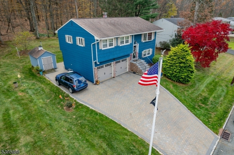
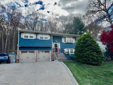
36 Deer Path Dr Flanders, NJ 07836
Estimated payment $3,868/month
Highlights
- Deck
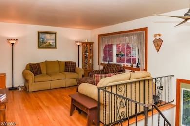
- Wood Flooring
- Attic
- Mount Olive High School Rated A
- Main Floor Bedroom
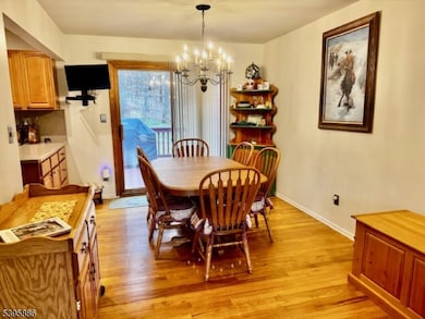
- Formal Dining Room
About This Home
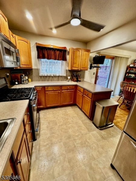
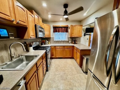
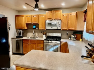
Nicely updated & well maintained. 4 Bedrooms, 1.5 baths. Oak Hard Wood floors. Eat in Kitchen with TV included. Main bath with skylight. Paver Block driveway to new lime stone steps. 16K whole house generator. Appliances stay. Outdoor automatic motion detector lights. Home Warranty for 1 year included.
Listing Agent
COLDWELL BANKER REALTY Brokerage Phone: 973-713-5714 Listed on: 11/05/2025

Home Details
Home Type
- Single Family
Est. Annual Taxes
- $9,740
Year Built
- Built in 1968
Lot Details
- 9,583 Sq Ft Lot
Parking
- 2 Car Attached Garage
Home Design
- Bi-Level Home
- Brick Exterior Construction
- Wood Siding
- Composition Shingle
- Tile
Interior Spaces
- Blinds
- Living Room
- Formal Dining Room
- Attic
Kitchen
- Gas Oven or Range
- Microwave
- Dishwasher
Flooring
- Wood
- Wall to Wall Carpet
Bedrooms and Bathrooms
- 4 Bedrooms
- Main Floor Bedroom
- Powder Room
Laundry
- Dryer
- Washer
Home Security
- Carbon Monoxide Detectors
- Fire and Smoke Detector
Outdoor Features
- Deck
- Patio
- Storage Shed
Utilities
- Forced Air Heating and Cooling System
- One Cooling System Mounted To A Wall/Window
- Standard Electricity
Listing and Financial Details
- Assessor Parcel Number 2327-06409-0000-00002-0000-
Map
Home Values in the Area
Average Home Value in this Area
Tax History
| Year | Tax Paid | Tax Assessment Tax Assessment Total Assessment is a certain percentage of the fair market value that is determined by local assessors to be the total taxable value of land and additions on the property. | Land | Improvement |
|---|---|---|---|---|
| 2025 | $9,741 | $279,500 | $172,700 | $106,800 |
| 2024 | $9,187 | $279,500 | $172,700 | $106,800 |
| 2023 | $9,187 | $279,500 | $172,700 | $106,800 |
| 2022 | $9,386 | $279,500 | $172,700 | $106,800 |
| 2021 | $9,386 | $279,500 | $172,700 | $106,800 |
| 2020 | $9,260 | $279,500 | $172,700 | $106,800 |
| 2019 | $9,229 | $279,500 | $172,700 | $106,800 |
| 2018 | $9,140 | $279,500 | $172,700 | $106,800 |
| 2017 | $8,980 | $279,500 | $172,700 | $106,800 |
| 2016 | $8,695 | $279,500 | $172,700 | $106,800 |
| 2015 | $8,899 | $279,500 | $172,700 | $106,800 |
| 2014 | $8,908 | $279,500 | $172,700 | $106,800 |
Property History
| Date | Event | Price | List to Sale | Price per Sq Ft |
|---|---|---|---|---|
| 11/05/2025 11/05/25 | For Sale | $579,900 | -- | -- |
Purchase History
| Date | Type | Sale Price | Title Company |
|---|---|---|---|
| Deed | $190,000 | -- | |
| Deed | $150,000 | First American |
Mortgage History
| Date | Status | Loan Amount | Loan Type |
|---|---|---|---|
| Open | $150,000 | No Value Available |
Source: Garden State MLS
MLS Number: 3996604
APN: 27-06409-0000-00002
Disclaimer: Certain information contained herein is derived from information provided by parties other than Homes.com. All information provided is deemed reliable, but is not guaranteed to be accurate and should be independently verified.
![]() The data relating to real estate for sale on this website comes in part from the IDX Program of Garden State Multiple Listing Service, L.L.C. Real estate listings held by other brokerage firms are marked as IDX Listing.
The data relating to real estate for sale on this website comes in part from the IDX Program of Garden State Multiple Listing Service, L.L.C. Real estate listings held by other brokerage firms are marked as IDX Listing.
Information deemed reliable but not guaranteed.
Copyright © 2025 Garden State Multiple Listing Service, L.L.C. All rights reserved.
Notice: The dissemination of listings on this website does not constitute the consent required by N.J.A.C. 11:5.6.1 (n) for the advertisement of listings exclusively for sale by another broker. Any such consent must be obtained in writing from the listing broker.
This information is being provided for Consumers’ personal, non-commercial use and may not be used for any purpose other than to identify prospective properties Consumers may be interested in purchasing.
- 50 Clover Hill Dr
- 15 Deer Path Dr
- 57 Clover Hill Dr
- 39 Alden Terrace
- 150 Clover Hill Dr
- 7 Virgil Ln
- 138 Bartley Flanders Rd
- 32 Four Bridges Rd
- 209 Pleasant Hill Rd
- 4 Mill Rd
- 000 S 4 Bridges Rd
- 15 Prides Crossing
- 6 Ironia Rd
- 532 Drakestown Rd
- 3 Cathy Ln
- 19 Park Place
- 21 Barkman Way
- 33 Chancellor Way
- 117 Upper Sunset Dr
- 23 Hillside Ave
- 1000 Marveland Crescent St
- 76 Main St
- 100 Oakwood Village
- 15 Kings Village
- 62 Wolfe Rd Unit 63
- 4 Greenwich Ct
- 29 Mount Olive Rd Unit 1
- 22 Cassedy Rd
- 66 Whisper Way E
- 8 Lamerson Cir
- 216 Woods Edge Dr Unit 216
- 26 Schooleys Mountain Rd
- 16 Schooleys Mountain Rd
- 54 Swackhammer Way
- 76 Swackhammer Way
- 20 Peckwell St
- 71 International Dr S
- 19 Flintlock Dr
- 7 W Maple Ave
- 124 Drake Ln Unit 124