Estimated Value: $974,000 - $1,069,756
3
Beds
3
Baths
2,319
Sq Ft
$449/Sq Ft
Est. Value
About This Home
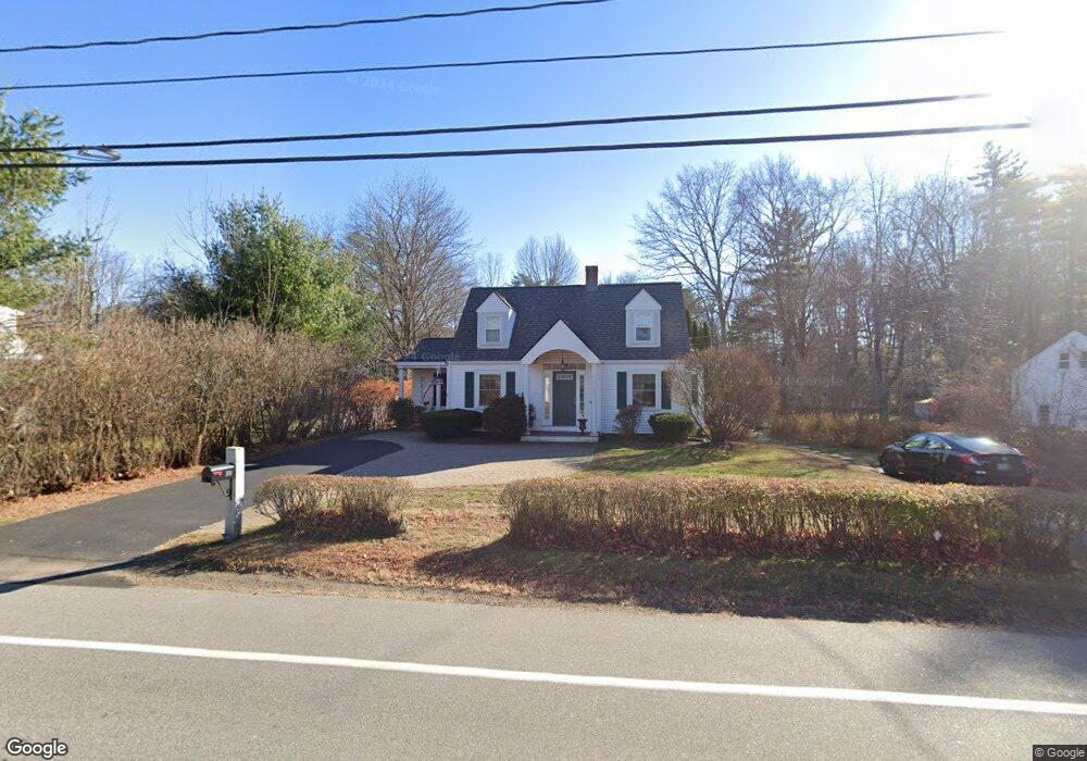
This home is located at 360 Wallis Rd, Rye, NH 03870 and is currently estimated at $1,040,439, approximately $448 per square foot. 360 Wallis Rd is a home located in Rockingham County with nearby schools including Rye Elementary School, Rye Junior High School, and Rye Country Day School.
Ownership History
Date
Name
Owned For
Owner Type
Purchase Details
Closed on
Aug 1, 1997
Sold by
Paul A Willis Ret and T
Bought by
Alden Matthew A and Alden Gianna P
Current Estimated Value
Home Financials for this Owner
Home Financials are based on the most recent Mortgage that was taken out on this home.
Original Mortgage
$163,400
Outstanding Balance
$24,513
Interest Rate
7.55%
Mortgage Type
Purchase Money Mortgage
Estimated Equity
$1,015,926
Create a Home Valuation Report for This Property
The Home Valuation Report is an in-depth analysis detailing your home's value as well as a comparison with similar homes in the area
Home Values in the Area
Average Home Value in this Area
Purchase History
| Date | Buyer | Sale Price | Title Company |
|---|---|---|---|
| Alden Matthew A | $172,000 | -- |
Source: Public Records
Mortgage History
| Date | Status | Borrower | Loan Amount |
|---|---|---|---|
| Open | Alden Matthew A | $163,400 |
Source: Public Records
Tax History Compared to Growth
Tax History
| Year | Tax Paid | Tax Assessment Tax Assessment Total Assessment is a certain percentage of the fair market value that is determined by local assessors to be the total taxable value of land and additions on the property. | Land | Improvement |
|---|---|---|---|---|
| 2024 | $6,086 | $702,800 | $389,600 | $313,200 |
| 2023 | $5,643 | $702,800 | $389,600 | $313,200 |
| 2022 | $4,901 | $702,100 | $389,600 | $312,500 |
| 2021 | $5,317 | $520,300 | $287,400 | $232,900 |
| 2020 | $5,317 | $520,300 | $287,400 | $232,900 |
| 2019 | $5,317 | $520,300 | $287,400 | $232,900 |
| 2018 | $5,260 | $520,300 | $287,400 | $232,900 |
| 2017 | $5,260 | $520,300 | $287,400 | $232,900 |
| 2016 | $4,691 | $439,200 | $209,000 | $230,200 |
| 2015 | $4,787 | $439,200 | $209,000 | $230,200 |
| 2013 | $4,804 | $437,900 | $209,000 | $228,900 |
Source: Public Records
Map
Nearby Homes
- 480 Sagamore Rd
- 137 Clark Rd
- 916 Springbrook Cir
- 45 F w Hartford Dr
- 1215 Ocean Blvd Unit 5
- 1215 Ocean Blvd Unit 6
- 1193 Ocean Blvd
- 1191 - 1193 Ocean Blvd
- 1 Pheasant Ln
- 239 Grant Ave
- 2075 Lafayette Rd Unit B17
- 1643 Ocean Blvd
- 14 Sagamore Rd Unit 3
- 80 Constitution Ave Unit 225
- 80 Constitution Ave Unit 317
- 80 Constitution Ave Unit 231
- 80 Constitution Ave Unit 408
- 80 Constitution Ave Unit 310
- 80 Constitution Ave Unit 327
- 80 Constitution Ave Unit 209
- 551 Long John Rd
- 370 Wallis Rd
- 354 Wallis Rd
- 559 Long John Rd
- 371 Wallis Rd
- 378 Wallis Rd
- 355 Wallis Rd
- 382 Wallis Rd
- 575 Long John Rd
- 346 Wallis Rd
- 351 Wallis Rd
- 556 Long John Rd
- 560 Long John Rd
- 386 Wallis Rd
- 550 Long John Rd
- 550 Long John Rd Unit ID1333595P
- 1 Victory Ln
- 3 Victory Ln
- 330 Wallis Rd
- 387 Wallis Rd