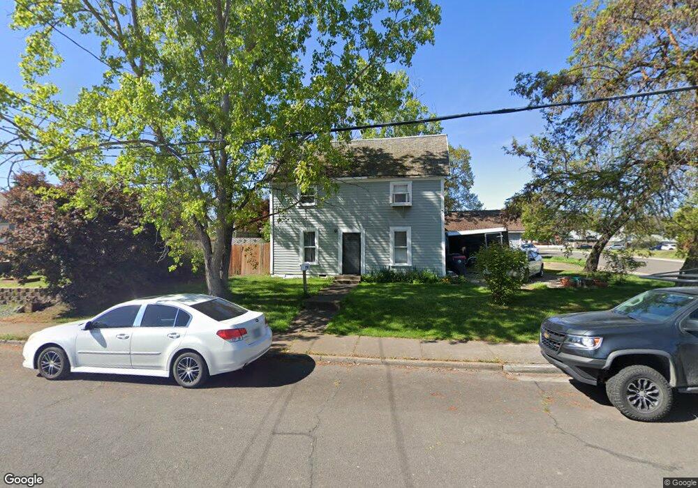
361 N 4th St Central Point, OR 97502
Estimated Value: $257,515 - $329,000
4
Beds
3
Baths
1,308
Sq Ft
$215/Sq Ft
Est. Value
About This Home
This home is located at 361 N 4th St, Central Point, OR 97502 and is currently estimated at $281,379, approximately $215 per square foot. 361 N 4th St is a home located in Jackson County with nearby schools including Jewett Elementary School, Scenic Middle School, and Crater High School.
Ownership History
Date
Name
Owned For
Owner Type
Purchase Details
Closed on
Mar 21, 2019
Sold by
Peterson Rebecca Kay and Keele Heidi
Bought by
Cox Chrisotpher Paul Nelson
Current Estimated Value
Purchase Details
Closed on
Oct 23, 2013
Sold by
Jeffries Rhinehart Rebecca Kay
Bought by
Peterson Rebecca Kay and The Rebecca Kay Peterson Revocable Livin
Purchase Details
Closed on
Sep 16, 2004
Sold by
Rhinehart Rebecca K
Bought by
Rhinehart Rebecca Kay and Rebecca Rhinehart Jeffries Revocable Liv
Create a Home Valuation Report for This Property
The Home Valuation Report is an in-depth analysis detailing your home's value as well as a comparison with similar homes in the area
Purchase History
We collect this data history from publicly available records. To have your information removed, we recommend requesting removal directly through your county’s website.
| Date | Buyer | Sale Price | Title Company |
|---|---|---|---|
| Cox Chrisotpher Paul Nelson | -- | None Available | |
| Peterson Rebecca Kay | -- | None Available | |
| Rhinehart Rebecca Kay | -- | -- |
Source: Public Records
Tax History
| Year | Tax Paid | Tax Assessment Tax Assessment Total Assessment is a certain percentage of the fair market value that is determined by local assessors to be the total taxable value of land and additions on the property. | Land | Improvement |
|---|---|---|---|---|
| 2026 | $2,204 | $133,170 | -- | -- |
| 2025 | $2,150 | $129,300 | $51,840 | $77,460 |
| 2024 | $2,150 | $125,540 | $50,330 | $75,210 |
| 2023 | $2,081 | $121,890 | $48,870 | $73,020 |
| 2022 | $2,032 | $121,890 | $48,870 | $73,020 |
| 2021 | $1,974 | $118,340 | $47,450 | $70,890 |
| 2020 | $1,917 | $114,900 | $46,070 | $68,830 |
| 2019 | $1,870 | $108,320 | $43,440 | $64,880 |
| 2018 | $1,813 | $105,170 | $42,180 | $62,990 |
| 2017 | $1,767 | $105,170 | $42,180 | $62,990 |
| 2016 | $1,716 | $99,140 | $39,770 | $59,370 |
| 2015 | $1,644 | $99,140 | $39,770 | $59,370 |
| 2014 | $1,602 | $93,460 | $37,500 | $55,960 |
Source: Public Records
Map
Nearby Homes
- 342 Hazel St
- 625 Cherry St
- 55 Crater Ln
- 0 N 3rd St
- 547 Laurel St
- 441 N 1st St
- 106 Victoria Way
- 359 Jans Ct
- 0 Peninger Rd
- 4626 N Pacific Hwy
- 0 Boulder Ridge St
- 1099 N Haskell St
- 196 Nadine Ln
- 501 Palo Verde Way
- 349 W Pine St
- 450 Freeman Rd
- 120 Nadine Ln
- 252 Jena Ct Unit 1
- 356 Marian Ave Unit 40
- 440 Bush St
Your Personal Tour Guide
Ask me questions while you tour the home.