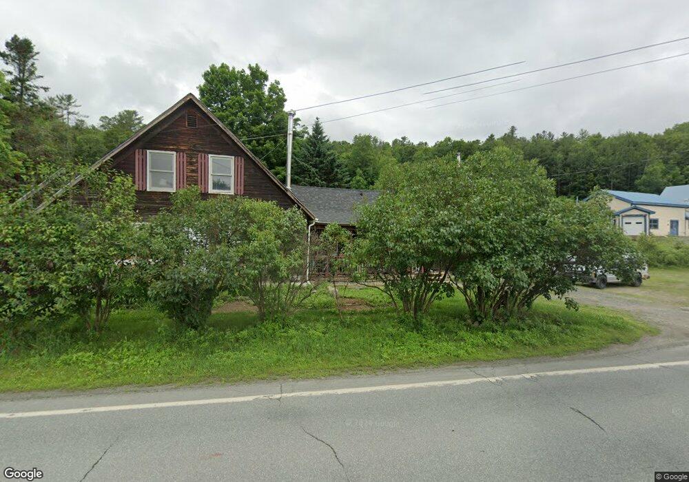
3625 Route 302 Lisbon, NH 03585
Estimated Value: $109,000 - $321,000
3
Beds
1
Bath
1,943
Sq Ft
$128/Sq Ft
Est. Value
About This Home
This home is located at 3625 Route 302, Lisbon, NH 03585 and is currently estimated at $247,814, approximately $127 per square foot. 3625 Route 302 is a home located in Grafton County with nearby schools including Lisbon Regional Middle School, North Country Charter Academy (M), and North Country Charter Academy.
Ownership History
Date
Name
Owned For
Owner Type
Purchase Details
Closed on
Jan 27, 2006
Sold by
Higginbotham Glen W and Higginbotham Ella
Bought by
Ferro Peter
Current Estimated Value
Home Financials for this Owner
Home Financials are based on the most recent Mortgage that was taken out on this home.
Original Mortgage
$75,600
Outstanding Balance
$42,912
Interest Rate
6.34%
Mortgage Type
Purchase Money Mortgage
Estimated Equity
$204,902
Create a Home Valuation Report for This Property
The Home Valuation Report is an in-depth analysis detailing your home's value as well as a comparison with similar homes in the area
Home Values in the Area
Average Home Value in this Area
Purchase History
| Date | Buyer | Sale Price | Title Company |
|---|---|---|---|
| Ferro Peter | $94,500 | -- |
Source: Public Records
Mortgage History
| Date | Status | Borrower | Loan Amount |
|---|---|---|---|
| Open | Ferro Peter | $75,600 | |
| Previous Owner | Ferro Peter | $70,500 |
Source: Public Records
Tax History Compared to Growth
Tax History
| Year | Tax Paid | Tax Assessment Tax Assessment Total Assessment is a certain percentage of the fair market value that is determined by local assessors to be the total taxable value of land and additions on the property. | Land | Improvement |
|---|---|---|---|---|
| 2024 | $4,248 | $212,600 | $44,700 | $167,900 |
| 2023 | $3,412 | $99,600 | $23,300 | $76,300 |
| 2022 | $3,414 | $99,600 | $23,300 | $76,300 |
| 2021 | $3,230 | $99,600 | $23,300 | $76,300 |
| 2020 | $3,378 | $99,600 | $23,300 | $76,300 |
| 2019 | $3,055 | $99,600 | $23,300 | $76,300 |
| 2018 | $2,737 | $87,100 | $22,700 | $64,400 |
| 2016 | $2,544 | $88,700 | $22,700 | $66,000 |
| 2015 | $2,544 | $88,700 | $22,700 | $66,000 |
| 2014 | $2,675 | $88,700 | $22,700 | $66,000 |
| 2012 | $2,787 | $86,000 | $25,200 | $60,800 |
Source: Public Records
Map
Nearby Homes
- 113 Buck Ridge Rd
- 00 Buck Ridge Rd Unit A03 & A04
- 00 Buck Ridge and Catterall Rd Unit A03 & A04
- Lot 4 Catterall Rd
- 00 Catterall Rd Unit A03 & A04
- 74-44 Slate Ledge Rd
- 99 Girard Rd
- 92-29 Birchcroft Dr
- 000 Dells Rd Unit 1
- 324 Crane Hill Rd
- 166 Riverside Dr
- 877 St Johnsbury Rd
- 60-70 Meadow St
- 10 Harvest Ct
- 134 Cottage St
- 194 Main St
- 165 Bethlehem Rd
- 251 Bethlehem Rd
- 36 MacIver Rd
- 33 Pleasant St
- 1713 Meadow St
- 1710 Meadow St
- 1678 Meadow St
- 469 Mount Eustis Rd
- 3541 U S 302
- 3541 Route 302
- 3521 Route 302
- 1599 Mount Eustis Rd
- 1516 Mount Eustis Rd
- Lots 9,12,13 Mount Eustis Rd Unit Map 33 Lots 9,12,13
- 1550 Meadow St
- 400 Mount Eustis Rd
- 3415 Route 302
- 1513 Mount Eustis Rd
- 370 Mount Eustis Rd
- 373 Mount Eustis Rd
- 1435 Mount Eustis Rd
- 1515 Mount Eustis Rd
- 330 Mount Eustis Rd
- 1437 Mount Eustis Rd