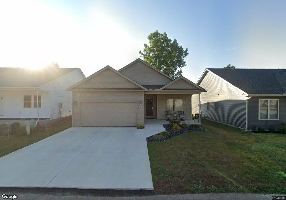
367 Brookside Dr Chillicothe, OH 45601
Estimated Value: $299,000 - $324,000
2
Beds
2
Baths
1,408
Sq Ft
$224/Sq Ft
Est. Value
About This Home
This home is located at 367 Brookside Dr, Chillicothe, OH 45601 and is currently estimated at $314,859, approximately $223 per square foot. 367 Brookside Dr is a home located in Ross County with nearby schools including Unioto Elementary School, Unioto Middle School, and Unioto High School.
Ownership History
Date
Name
Owned For
Owner Type
Purchase Details
Closed on
Apr 19, 2024
Sold by
Bullfrog Management Llc
Bought by
Mills Mark A and Snyder Evelyn M
Current Estimated Value
Home Financials for this Owner
Home Financials are based on the most recent Mortgage that was taken out on this home.
Original Mortgage
$174,900
Outstanding Balance
$172,282
Interest Rate
6.87%
Mortgage Type
New Conventional
Estimated Equity
$142,577
Purchase Details
Closed on
Feb 21, 2023
Sold by
Brookside Center Inc
Bought by
Bullfrog Management Llc
Home Financials for this Owner
Home Financials are based on the most recent Mortgage that was taken out on this home.
Original Mortgage
$96,000
Interest Rate
6.33%
Mortgage Type
Seller Take Back
Create a Home Valuation Report for This Property
The Home Valuation Report is an in-depth analysis detailing your home's value as well as a comparison with similar homes in the area
Home Values in the Area
Average Home Value in this Area
Purchase History
| Date | Buyer | Sale Price | Title Company |
|---|---|---|---|
| Mills Mark A | $299,900 | Chicago Title | |
| Bullfrog Management Llc | $144,000 | Title First Agency | |
| Bullfrog Management Llc | $144,000 | Title First Agency |
Source: Public Records
Mortgage History
| Date | Status | Borrower | Loan Amount |
|---|---|---|---|
| Open | Mills Mark A | $174,900 | |
| Previous Owner | Bullfrog Management Llc | $96,000 |
Source: Public Records
Tax History Compared to Growth
Tax History
| Year | Tax Paid | Tax Assessment Tax Assessment Total Assessment is a certain percentage of the fair market value that is determined by local assessors to be the total taxable value of land and additions on the property. | Land | Improvement |
|---|---|---|---|---|
| 2024 | $3,282 | $92,850 | $2,350 | $90,500 |
| 2023 | $3,282 | $2,350 | $2,350 | $0 |
| 2022 | $85 | $2,350 | $2,350 | $0 |
| 2021 | $70 | $1,820 | $1,820 | $0 |
| 2020 | $71 | $1,820 | $1,820 | $0 |
| 2019 | $71 | $1,820 | $1,820 | $0 |
| 2018 | $67 | $1,690 | $1,690 | $0 |
| 2017 | $67 | $1,690 | $1,690 | $0 |
| 2016 | $65 | $1,690 | $1,690 | $0 |
| 2015 | -- | $0 | $0 | $0 |
Source: Public Records
Map
Nearby Homes
- 35 Pickett Ct
- 12828 Pleasant Valley Rd
- 2956 Egypt Pike
- 246 Brown Ave
- 81 Brown Ave
- 12190 Pleasant Valley Rd
- 130 Copperfield Dr
- 14996 Pleasant Valley Rd Unit Lot 60
- 14996 Pleasant Valley Rd
- 6 Winesap Ct
- 637 Vernon Dr
- 8 Mcintosh Ct
- 88 Fruit Hill Dr
- 677 Adena Rd
- 18 Ridge Dr
- 15142 Pleasant Valley Rd
- 69 Infirmary Ln
- 833 W Fairview St
- 313 Goodale Dr
- 239 Almahurst Dr
- 352 Brookside Dr
- 307 Brookside Dr
- 380 Brookside Dr
- 387 Brookside Dr
- 265 Brookside Dr
- 387 Brookside Dr
- 379 Brookside Dr
- 247 Brookside Dr Unit Lot 19
- 257 Brookside Dr
- 477 Brookside Dr
- 459 Brookside Dr
- 390 Brookside Dr
- 450 Brookside Dr
- 452 Brookside Dr
- 454 Brookside Dr
- 2155 Egypt Pike
- 2297 Egypt Pike
- Lot 19 Brookside Dr
- Lot 17 Brookside Dr
- Lot 18 Brookside Dr