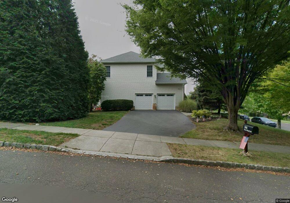
3696 Green Ridge Rd Furlong, PA 18925
Estimated Value: $1,017,945 - $1,041,000
4
Beds
3
Baths
3,738
Sq Ft
$276/Sq Ft
Est. Value
About This Home
This home is located at 3696 Green Ridge Rd, Furlong, PA 18925 and is currently estimated at $1,030,486, approximately $275 per square foot. 3696 Green Ridge Rd is a home located in Bucks County with nearby schools including Bridge Valley Elementary School, Holicong Middle School, and Central Bucks High School - East.
Ownership History
Date
Name
Owned For
Owner Type
Purchase Details
Closed on
Jan 30, 2004
Sold by
Toll Pa Lp
Bought by
Crovo Paul and Crovo Annette
Current Estimated Value
Home Financials for this Owner
Home Financials are based on the most recent Mortgage that was taken out on this home.
Original Mortgage
$310,000
Outstanding Balance
$145,086
Interest Rate
5.8%
Mortgage Type
Purchase Money Mortgage
Estimated Equity
$885,400
Create a Home Valuation Report for This Property
The Home Valuation Report is an in-depth analysis detailing your home's value as well as a comparison with similar homes in the area
Home Values in the Area
Average Home Value in this Area
Purchase History
| Date | Buyer | Sale Price | Title Company |
|---|---|---|---|
| Crovo Paul | $549,469 | T A Title Insurance Co |
Source: Public Records
Mortgage History
| Date | Status | Borrower | Loan Amount |
|---|---|---|---|
| Open | Crovo Paul | $310,000 |
Source: Public Records
Tax History Compared to Growth
Tax History
| Year | Tax Paid | Tax Assessment Tax Assessment Total Assessment is a certain percentage of the fair market value that is determined by local assessors to be the total taxable value of land and additions on the property. | Land | Improvement |
|---|---|---|---|---|
| 2025 | $9,596 | $58,940 | $13,640 | $45,300 |
| 2024 | $9,596 | $58,940 | $13,640 | $45,300 |
| 2023 | $9,271 | $58,940 | $13,640 | $45,300 |
| 2022 | $9,160 | $58,940 | $13,640 | $45,300 |
| 2021 | $9,050 | $58,940 | $13,640 | $45,300 |
| 2020 | $9,050 | $58,940 | $13,640 | $45,300 |
| 2019 | $8,991 | $58,940 | $13,640 | $45,300 |
| 2018 | $8,991 | $58,940 | $13,640 | $45,300 |
| 2017 | $8,918 | $58,940 | $13,640 | $45,300 |
| 2016 | $9,006 | $58,940 | $13,640 | $45,300 |
| 2015 | -- | $58,940 | $13,640 | $45,300 |
| 2014 | -- | $58,940 | $13,640 | $45,300 |
Source: Public Records
Map
Nearby Homes
- 3772 Powder Horn Dr
- 3657 Powder Horn Dr
- lot #3 next to 3739 York Rd
- 2479 Wheatfield Ln
- 2209 Swamp Rd
- 1948 Forest Grove Rd
- 2080 Bedfordshire Rd
- 0 Old York Rd Unit PABU2103356
- 3889 Robin Rd
- 4549 Lower Mountain Rd
- 106 Saddle Dr
- 2728 Red Gate Dr
- 2372 Dorchester St W Unit W
- 1908 Durham Rd
- 4448 Lower Mountain Rd
- 3060 Cloverly Dr
- 3017 Dorchester St E Unit 125
- 2443 Sugar Bottom Rd
- 3775 Buckingham Dr
- 2880 Snake Hill Rd
- 3791 Powder Horn Dr
- 3690 Green Ridge Rd
- 3787 Powder Horn Dr
- 3697 Green Ridge Rd
- 3693 Green Ridge Rd
- 3790 Powder Horn Dr
- 3701 Green Ridge Rd
- 3794 Powder Horn Dr
- 3796 Forest Hill Dr
- 3686 Green Ridge Rd
- 3781 Powder Horn Dr
- 3705 Green Ridge Rd
- 3706 Green Ridge Rd
- 3786 Powder Horn Dr
- 3802 Forest Hill Dr
- 3682 Green Ridge Rd
- 3711 Green Ridge Rd
- 3782 Powder Horn Dr
- 3797 Forest Hill Dr
- 3808 Forest Hill Dr