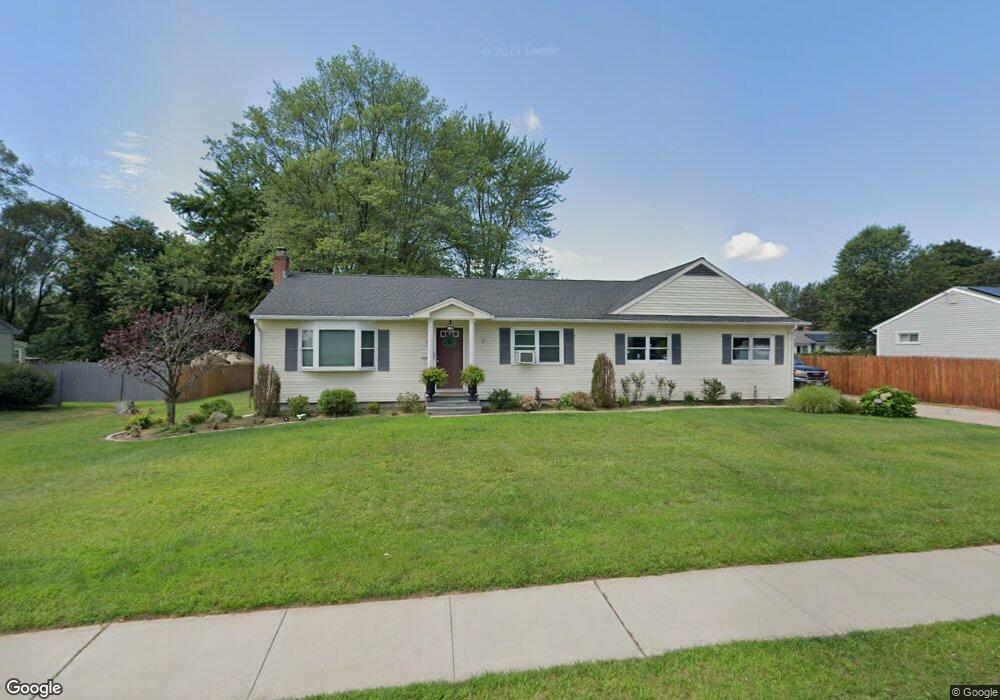
37 Sherman Rd Enfield, CT 06082
Estimated Value: $234,000 - $333,000
3
Beds
2
Baths
1,064
Sq Ft
$261/Sq Ft
Est. Value
About This Home
This home is located at 37 Sherman Rd, Enfield, CT 06082 and is currently estimated at $277,588, approximately $260 per square foot. 37 Sherman Rd is a home located in Hartford County with nearby schools including Nathan Hale Elementary School, Eli Whitney Elementary School, and John F. Kennedy Middle School.
Ownership History
Date
Name
Owned For
Owner Type
Purchase Details
Closed on
Apr 25, 2011
Sold by
Lamontagne Tammy
Bought by
Lamontagne Troy
Current Estimated Value
Purchase Details
Closed on
Feb 25, 2010
Sold by
Department Of Housing & Urban Dev
Bought by
Lamontagne Troy and Lamontagne Tammy
Purchase Details
Closed on
Dec 2, 2009
Sold by
Gmac Mortgage Llc
Bought by
Department Of Housing & Urban Dev
Purchase Details
Closed on
May 31, 1989
Sold by
Warner Dana
Bought by
Deskis Thomas
Home Financials for this Owner
Home Financials are based on the most recent Mortgage that was taken out on this home.
Original Mortgage
$79,000
Interest Rate
10.92%
Create a Home Valuation Report for This Property
The Home Valuation Report is an in-depth analysis detailing your home's value as well as a comparison with similar homes in the area
Home Values in the Area
Average Home Value in this Area
Purchase History
| Date | Buyer | Sale Price | Title Company |
|---|---|---|---|
| Lamontagne Troy | -- | -- | |
| Lamontagne Troy | $100,000 | -- | |
| Department Of Housing & Urban Dev | -- | -- | |
| Deskis Thomas | $132,750 | -- |
Source: Public Records
Mortgage History
| Date | Status | Borrower | Loan Amount |
|---|---|---|---|
| Previous Owner | Deskis Thomas | $7,500 | |
| Previous Owner | Deskis Thomas | $79,000 |
Source: Public Records
Tax History Compared to Growth
Tax History
| Year | Tax Paid | Tax Assessment Tax Assessment Total Assessment is a certain percentage of the fair market value that is determined by local assessors to be the total taxable value of land and additions on the property. | Land | Improvement |
|---|---|---|---|---|
| 2025 | $5,311 | $151,300 | $56,600 | $94,700 |
| 2024 | $5,115 | $151,300 | $56,600 | $94,700 |
| 2023 | $5,078 | $151,300 | $56,600 | $94,700 |
| 2022 | $4,674 | $151,300 | $56,600 | $94,700 |
| 2021 | $4,491 | $119,530 | $46,890 | $72,640 |
| 2020 | $4,461 | $119,530 | $46,890 | $72,640 |
| 2019 | $4,455 | $119,530 | $46,890 | $72,640 |
| 2018 | $4,335 | $119,530 | $46,890 | $72,640 |
| 2017 | $4,074 | $119,530 | $46,890 | $72,640 |
| 2016 | $4,186 | $125,480 | $48,110 | $77,370 |
| 2015 | $4,058 | $125,480 | $48,110 | $77,370 |
| 2014 | $3,956 | $125,480 | $48,110 | $77,370 |
Source: Public Records
Map
Nearby Homes
- 436 Taylor Rd
- 155 Sheridan Rd
- 31 Meade Ln
- 11 Northfield Rd
- 2 Meacham Dr Unit 2
- 4 Copley Cir
- 34 Ridgefield Rd
- 56 N Maple St
- 138 Main St
- 102 N Maple St Unit 1A
- 6 Cedar St
- 287 Hazard Ave
- 35 Therese Dr
- 12 Salerno Dr
- 45 Monroe Rd
- 3 Avon Street Extension
- 70 Fletcher Rd
- 83 Oldefield Farms Unit 83
- 85 Oldefield Farms Unit 85
- 12 the Laurels Unit 12