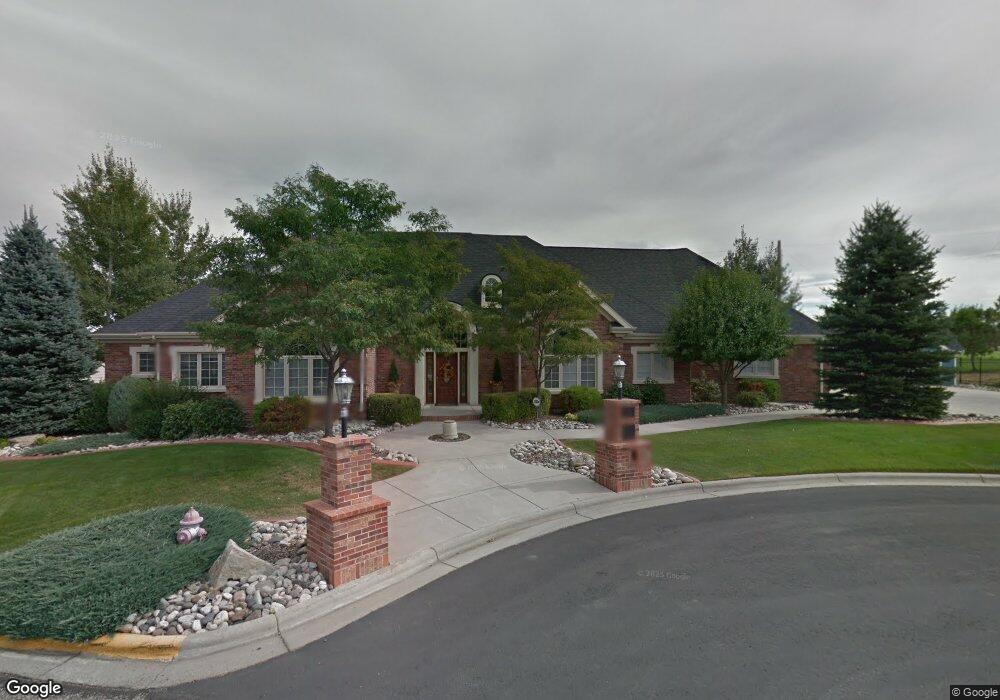
374 Burning Tree Dr Billings, MT 59105
Billings Heights NeighborhoodEstimated Value: $650,000 - $1,180,000
6
Beds
6
Baths
8,200
Sq Ft
$121/Sq Ft
Est. Value
About This Home
This home is located at 374 Burning Tree Dr, Billings, MT 59105 and is currently estimated at $991,479, approximately $120 per square foot. 374 Burning Tree Dr is a home located in Yellowstone County with nearby schools including Sandstone School, Castle Rock Junior High School, and Skyview High School.
Ownership History
Date
Name
Owned For
Owner Type
Purchase Details
Closed on
Apr 14, 2020
Sold by
Roberts Brandon J and Roberts Ashleigh M
Bought by
Roberts Brandon J and Roberts Ashleigh M
Current Estimated Value
Purchase Details
Closed on
Dec 12, 2017
Sold by
Bennion John W and Bennion Margaret W
Bought by
Roberts Family Trust
Home Financials for this Owner
Home Financials are based on the most recent Mortgage that was taken out on this home.
Original Mortgage
$697,645
Interest Rate
3.95%
Mortgage Type
Construction
Purchase Details
Closed on
Dec 1, 2015
Sold by
Speciality Properties Llc
Bought by
Bennion Enterprises Llc
Purchase Details
Closed on
Jan 20, 2006
Sold by
Lake Hills Golf Club
Bought by
Dj Properties Llc
Home Financials for this Owner
Home Financials are based on the most recent Mortgage that was taken out on this home.
Original Mortgage
$164,000
Interest Rate
6.32%
Mortgage Type
Purchase Money Mortgage
Create a Home Valuation Report for This Property
The Home Valuation Report is an in-depth analysis detailing your home's value as well as a comparison with similar homes in the area
Home Values in the Area
Average Home Value in this Area
Purchase History
| Date | Buyer | Sale Price | Title Company |
|---|---|---|---|
| Roberts Brandon J | -- | Stewart Title Company | |
| Roberts Family Trust | -- | First Montana Title Company | |
| Bennion Enterprises Llc | -- | Stewart Title | |
| Dj Properties Llc | -- | None Available |
Source: Public Records
Mortgage History
| Date | Status | Borrower | Loan Amount |
|---|---|---|---|
| Closed | Roberts Family Trust | $697,645 | |
| Previous Owner | Dj Properties Llc | $164,000 |
Source: Public Records
Tax History Compared to Growth
Tax History
| Year | Tax Paid | Tax Assessment Tax Assessment Total Assessment is a certain percentage of the fair market value that is determined by local assessors to be the total taxable value of land and additions on the property. | Land | Improvement |
|---|---|---|---|---|
| 2025 | $11,868 | $1,359,000 | $120,158 | $1,238,842 |
| 2024 | $11,868 | $1,215,000 | $105,194 | $1,109,806 |
| 2023 | $11,801 | $1,215,000 | $105,194 | $1,109,806 |
| 2022 | $7,724 | $818,100 | $0 | $0 |
| 2021 | $8,659 | $818,100 | $0 | $0 |
| 2020 | $8,705 | $787,000 | $0 | $0 |
| 2019 | $8,316 | $787,000 | $0 | $0 |
| 2018 | $8,443 | $786,000 | $0 | $0 |
| 2017 | $13,217 | $1,315,161 | $0 | $0 |
| 2016 | $12,876 | $1,292,435 | $0 | $0 |
| 2015 | $12,598 | $1,292,435 | $0 | $0 |
| 2014 | $8,471 | $450,288 | $0 | $0 |
Source: Public Records
Map
Nearby Homes
- 0 Clubhouse Way
- LOT 3 Clubhouse Way
- LOT 4 Clubhouse Way
- 2043 Cypress Point
- 2032 Clubhouse Way
- 2164 Greenbriar Rd
- 00 Winged Foot Drive Lot 10
- 0 Greenbriar Rd
- 00
- 650 Pinehurst Rd
- 0 Winged Foot Dr
- Lot 1, Block 1 Greenbriar Rd
- 2115 Saint Andrews Dr
- 2049 Saint Andrews Dr
- 2030 Gleneagles Blvd
- 1819 Gleneagles Blvd
- TBD Gleneagles Blvd
- 2029 Ridgeview Dr
- 1949 St Andrews Dr
- 2107 Morocco Dr
- 362 Burning Tree Dr
- 371 Burning Tree Dr
- 359 Burning Tree Dr
- 428 Tamarisk Dr
- 334 Burning Tree Dr
- 425 Tamarisk Dr
- 416 Tamarisk Dr
- 322 Burning Tree Dr
- 412 Tamarisk Dr
- 411 Tamarisk Dr
- 310 Burning Tree Dr
- 408 Tamarisk Dr
- 407 Tamarisk Dr
- 2010 Wentworth Dr
- 2018 Wentworth Dr
- 2004 Wentworth Dr
- 2020 Wentworth Dr
- 2000 Wentworth Dr
- 300 Eastlake Cir
- 401 Tamarisk Dr