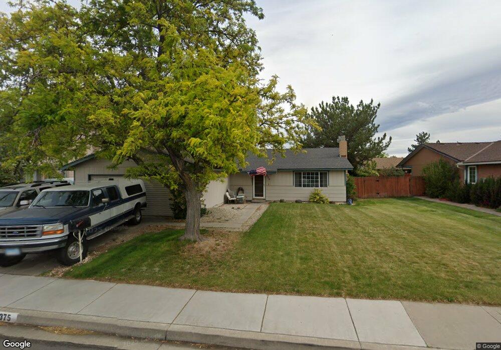
375 Gleeson Way Sparks, NV 89431
McCarran Boulevard-Probasco NeighborhoodEstimated Value: $428,000 - $443,000
3
Beds
2
Baths
1,589
Sq Ft
$275/Sq Ft
Est. Value
About This Home
This home is located at 375 Gleeson Way, Sparks, NV 89431 and is currently estimated at $436,264, approximately $274 per square foot. 375 Gleeson Way is a home located in Washoe County with nearby schools including Greenbrae Elementary School, George L Dilworth Middle School, and Sparks High School.
Ownership History
Date
Name
Owned For
Owner Type
Purchase Details
Closed on
Jul 1, 2025
Sold by
Date Curtis T
Bought by
Curtis Date Trust and Date
Current Estimated Value
Purchase Details
Closed on
Apr 7, 2005
Sold by
Roesler Kenneth J and Roesler Mary Jane
Bought by
Date Curtis T
Home Financials for this Owner
Home Financials are based on the most recent Mortgage that was taken out on this home.
Original Mortgage
$160,000
Interest Rate
6.02%
Mortgage Type
Fannie Mae Freddie Mac
Purchase Details
Closed on
Sep 24, 1999
Sold by
Roesler Kenneth J
Bought by
Roesler Kenneth J and Roesler Mary Jane
Create a Home Valuation Report for This Property
The Home Valuation Report is an in-depth analysis detailing your home's value as well as a comparison with similar homes in the area
Home Values in the Area
Average Home Value in this Area
Purchase History
| Date | Buyer | Sale Price | Title Company |
|---|---|---|---|
| Curtis Date Trust | -- | None Listed On Document | |
| Date Curtis T | $260,000 | Founders Title Company Of Nv | |
| Roesler Kenneth J | -- | -- |
Source: Public Records
Mortgage History
| Date | Status | Borrower | Loan Amount |
|---|---|---|---|
| Previous Owner | Date Curtis T | $160,000 |
Source: Public Records
Tax History Compared to Growth
Tax History
| Year | Tax Paid | Tax Assessment Tax Assessment Total Assessment is a certain percentage of the fair market value that is determined by local assessors to be the total taxable value of land and additions on the property. | Land | Improvement |
|---|---|---|---|---|
| 2025 | $1,505 | $63,183 | $33,565 | $29,618 |
| 2024 | $1,505 | $60,633 | $30,065 | $30,568 |
| 2023 | $728 | $60,930 | $31,325 | $29,605 |
| 2022 | $1,419 | $51,363 | $26,180 | $25,183 |
| 2021 | $1,378 | $43,575 | $17,955 | $25,620 |
| 2020 | $1,337 | $43,101 | $16,940 | $26,161 |
| 2019 | $1,298 | $41,640 | $15,890 | $25,750 |
| 2018 | $1,260 | $37,350 | $11,725 | $25,625 |
| 2017 | $1,224 | $36,469 | $10,395 | $26,074 |
| 2016 | $1,193 | $36,328 | $9,345 | $26,983 |
| 2015 | $1,192 | $35,065 | $7,700 | $27,365 |
| 2014 | $1,157 | $33,141 | $6,440 | $26,701 |
| 2013 | -- | $30,918 | $4,270 | $26,648 |
Source: Public Records
Map
Nearby Homes
- 385 Gleeson Way
- 370 O'Brien Way
- 848 Parkside Dr Unit 1
- 801 Woodglen Dr Unit 2
- 949 Crestwood Dr Unit 3
- 360 E Lincoln Way
- 684 Oakwood Dr Unit 3
- 8 E O St
- 644 Oakwood Dr Unit 2
- 611 Oakwood Dr Unit 1
- 300 I St
- 601 Oakwood Dr Unit 4
- 604 Oakwood Dr Unit 1
- 445 Pine Meadows Dr Unit E25
- 857 Cherry Tree Dr Unit 3
- 1703 1st St
- 560 Nichols Blvd
- 10 Lincoln Way
- 907 Camino Real Dr
- 345 H St