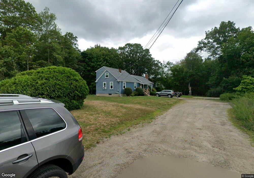
38 Betts Dr North Attleboro, MA 02760
North Attleboro NeighborhoodEstimated Value: $499,829 - $509,000
3
Beds
1
Bath
1,705
Sq Ft
$296/Sq Ft
Est. Value
About This Home
This home is located at 38 Betts Dr, North Attleboro, MA 02760 and is currently estimated at $505,457, approximately $296 per square foot. 38 Betts Dr is a home located in Bristol County with nearby schools including North Attleboro High School.
Ownership History
Date
Name
Owned For
Owner Type
Purchase Details
Closed on
Jul 16, 1990
Sold by
Betts Donald R
Bought by
Betts Donald R
Current Estimated Value
Home Financials for this Owner
Home Financials are based on the most recent Mortgage that was taken out on this home.
Original Mortgage
$42,000
Interest Rate
10.17%
Mortgage Type
Purchase Money Mortgage
Purchase Details
Closed on
Oct 13, 1987
Sold by
Appleton James P
Bought by
Betts Donald R
Create a Home Valuation Report for This Property
The Home Valuation Report is an in-depth analysis detailing your home's value as well as a comparison with similar homes in the area
Home Values in the Area
Average Home Value in this Area
Purchase History
| Date | Buyer | Sale Price | Title Company |
|---|---|---|---|
| Betts Donald R | $103,000 | -- | |
| Betts Donald R | $124,000 | -- |
Source: Public Records
Mortgage History
| Date | Status | Borrower | Loan Amount |
|---|---|---|---|
| Open | Betts Donald R | $47,000 | |
| Closed | Betts Donald R | $42,000 |
Source: Public Records
Tax History Compared to Growth
Tax History
| Year | Tax Paid | Tax Assessment Tax Assessment Total Assessment is a certain percentage of the fair market value that is determined by local assessors to be the total taxable value of land and additions on the property. | Land | Improvement |
|---|---|---|---|---|
| 2025 | $4,705 | $399,100 | $139,300 | $259,800 |
| 2024 | $4,481 | $388,300 | $139,300 | $249,000 |
| 2023 | $4,584 | $358,400 | $139,300 | $219,100 |
| 2022 | $4,338 | $311,400 | $139,300 | $172,100 |
| 2021 | $3,793 | $318,900 | $139,300 | $179,600 |
| 2020 | $4,447 | $309,900 | $139,300 | $170,600 |
| 2019 | $4,232 | $297,200 | $126,600 | $170,600 |
| 2018 | $2,992 | $283,600 | $126,600 | $157,000 |
| 2017 | $2,694 | $267,000 | $126,600 | $140,400 |
| 2016 | $3,634 | $274,900 | $140,600 | $134,300 |
| 2015 | $3,355 | $255,300 | $140,600 | $114,700 |
| 2014 | $3,114 | $235,200 | $123,500 | $111,700 |
Source: Public Records
Map
Nearby Homes
- 12 Roosevelt Ave
- 99 Arnold Rd
- 16 Johnson St
- 60 Crescent Ave
- 12 Morgan Way
- 93 Bank St
- 85 Richards Ave
- 151 Roosevelt Ave Unit A
- 160 Crescent Ave
- 19 Metcalf Cir
- 80 Broadway Unit 9
- 19 Church St Unit A5
- 16 Richards Ave Unit 106
- 33 Ash St
- 20 South St
- 40 Sperry Ln
- 30 Sperry Ln Unit Lot 15
- 50 Metcalf Rd
- 20 Holbrook Ave
- 16 Elizabeth St
- 26 Betts Dr
- 25 Betts Dr
- 18 Betts Dr
- 15 Betts Dr
- 140 Caspian Way Unit 36
- 12 Betts Dr
- 153 Arnold Rd
- 141 Arnold Rd
- 151 Arnold Rd
- 135 Caspian Way Unit 35
- 137 Arnold Rd
- 169 Arnold Rd
- 131 Arnold Rd
- 179 REAR Arnold Rd
- 179 Arnold Rd
- 127 Caspian Way Unit 34
- 119 Arnold Rd
- 32 Phillips St
- 152 Arnold Rd
- 142 Arnold Rd