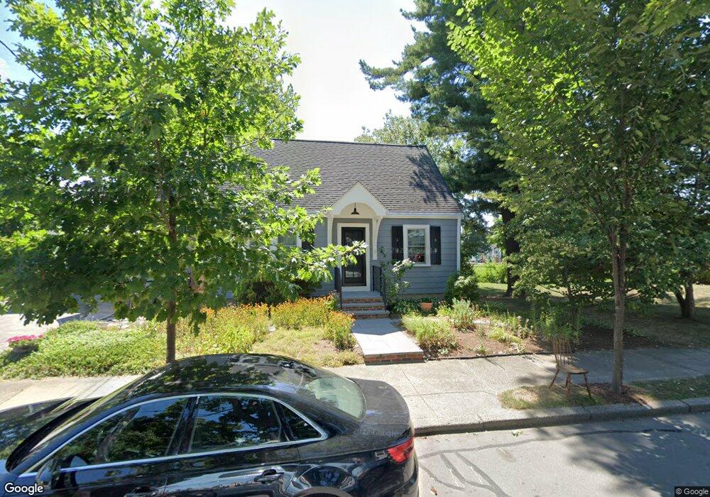
38 Clark Rd West Newton, MA 02465
West Newton NeighborhoodEstimated Value: $912,000 - $1,134,000
4
Beds
3
Baths
1,370
Sq Ft
$763/Sq Ft
Est. Value
About This Home
This home is located at 38 Clark Rd, West Newton, MA 02465 and is currently estimated at $1,045,724, approximately $763 per square foot. 38 Clark Rd is a home located in Middlesex County with nearby schools including Franklin Elementary School, F.A. Day Middle School, and Newton North High School.
Ownership History
Date
Name
Owned For
Owner Type
Purchase Details
Closed on
Aug 28, 2012
Sold by
Kohse Gordon E and Kohse Dunphy M
Bought by
38 Clark Road Rt and Kohse Gordon E
Current Estimated Value
Purchase Details
Closed on
Mar 14, 1996
Sold by
Stahl Elizabeth M and Zarowin David R
Bought by
Dunphy M Jane and Kohse Gordon E
Home Financials for this Owner
Home Financials are based on the most recent Mortgage that was taken out on this home.
Original Mortgage
$204,000
Interest Rate
6.97%
Mortgage Type
Purchase Money Mortgage
Purchase Details
Closed on
May 26, 1992
Sold by
Jacobson Joseph O and Jacobson Margaret J
Bought by
Zarowin David R and Stahl Elizabeth
Create a Home Valuation Report for This Property
The Home Valuation Report is an in-depth analysis detailing your home's value as well as a comparison with similar homes in the area
Home Values in the Area
Average Home Value in this Area
Purchase History
| Date | Buyer | Sale Price | Title Company |
|---|---|---|---|
| 38 Clark Road Rt | -- | -- | |
| Dunphy M Jane | $234,000 | -- | |
| Zarowin David R | $190,575 | -- |
Source: Public Records
Mortgage History
| Date | Status | Borrower | Loan Amount |
|---|---|---|---|
| Previous Owner | Zarowin David R | $300,000 | |
| Previous Owner | Zarowin David R | $192,000 | |
| Previous Owner | Zarowin David R | $204,000 | |
| Previous Owner | Zarowin David R | $180,500 |
Source: Public Records
Tax History Compared to Growth
Tax History
| Year | Tax Paid | Tax Assessment Tax Assessment Total Assessment is a certain percentage of the fair market value that is determined by local assessors to be the total taxable value of land and additions on the property. | Land | Improvement |
|---|---|---|---|---|
| 2025 | $7,802 | $796,100 | $725,300 | $70,800 |
| 2024 | $7,544 | $772,900 | $704,200 | $68,700 |
| 2023 | $7,078 | $695,300 | $526,600 | $168,700 |
| 2022 | $6,773 | $643,800 | $487,600 | $156,200 |
| 2021 | $9,347 | $607,400 | $460,000 | $147,400 |
| 2020 | $6,341 | $607,400 | $460,000 | $147,400 |
| 2019 | $6,162 | $589,700 | $446,600 | $143,100 |
| 2018 | $5,868 | $542,300 | $406,300 | $136,000 |
| 2017 | $5,689 | $511,600 | $383,300 | $128,300 |
| 2016 | $5,441 | $478,100 | $358,200 | $119,900 |
| 2015 | $5,187 | $446,800 | $334,800 | $112,000 |
Source: Public Records
Map
Nearby Homes
- 75 Cherry St
- 56 Dearborn St
- 76 Taft Ave Unit 1
- 76 Taft Ave
- 76 Taft Ave Unit 2
- 287 Cherry St Unit 2
- 44 Westland Ave
- 41 Kilburn Rd
- 24 Tolman St Unit A
- 76 Harding St
- 25 Tolman St Unit 2
- 162 Myrtle St Unit 1
- 14 Cottage Place Unit 14
- 138 Myrtle St Unit 2
- 212 River St Unit 2
- 265-267 River St Unit 267
- 265-267 River St Unit 265
- 106 River St Unit 18
- 106 River St Unit 2
- 106 River St Unit 14