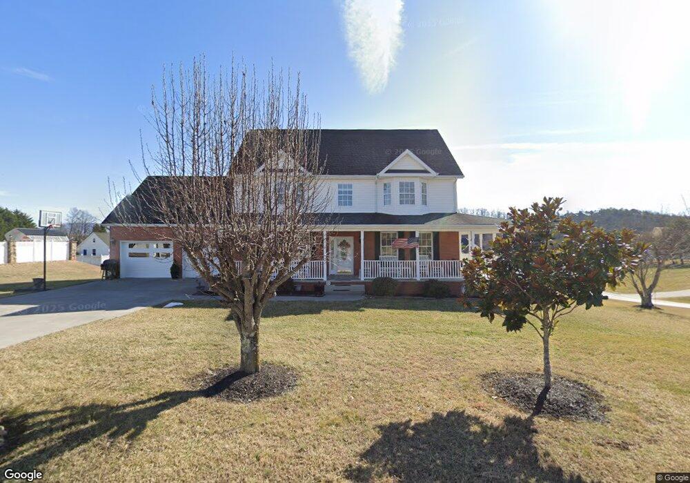
381 Terry Point Rd Dandridge, TN 37725
Estimated Value: $503,081 - $720,000
3
Beds
2
Baths
3,024
Sq Ft
$191/Sq Ft
Est. Value
About This Home
This home is located at 381 Terry Point Rd, Dandridge, TN 37725 and is currently estimated at $577,270, approximately $190 per square foot. 381 Terry Point Rd is a home located in Jefferson County.
Ownership History
Date
Name
Owned For
Owner Type
Purchase Details
Closed on
Apr 21, 2017
Sold by
Plymal Bob and Plymal Barbara B
Bought by
Plymal Barbara B Le Plymal Robert Craig Rem
Current Estimated Value
Purchase Details
Closed on
Nov 29, 2004
Sold by
Dennis Kosak
Bought by
Bob Plymal
Purchase Details
Closed on
Mar 31, 2004
Bought by
Kosak Dennis
Purchase Details
Closed on
Dec 12, 1997
Bought by
Hlinka John W and Hlinka Doris
Purchase Details
Closed on
Nov 28, 1994
Bought by
Hlinka Joseph W and Hlinka Helen S
Create a Home Valuation Report for This Property
The Home Valuation Report is an in-depth analysis detailing your home's value as well as a comparison with similar homes in the area
Home Values in the Area
Average Home Value in this Area
Purchase History
| Date | Buyer | Sale Price | Title Company |
|---|---|---|---|
| Plymal Barbara B Le Plymal Robert Craig Rem | -- | -- | |
| Bob Plymal | $190,000 | -- | |
| Kosak Dennis | $46,000 | -- | |
| Hlinka John W | $15,000 | -- | |
| Hlinka Joseph W | $30,000 | -- |
Source: Public Records
Tax History Compared to Growth
Tax History
| Year | Tax Paid | Tax Assessment Tax Assessment Total Assessment is a certain percentage of the fair market value that is determined by local assessors to be the total taxable value of land and additions on the property. | Land | Improvement |
|---|---|---|---|---|
| 2025 | $1,882 | $131,575 | $15,000 | $116,575 |
| 2023 | $1,644 | $71,475 | $0 | $0 |
| 2022 | $1,565 | $71,475 | $9,000 | $62,475 |
| 2021 | $1,565 | $71,475 | $9,000 | $62,475 |
| 2020 | $1,565 | $71,475 | $9,000 | $62,475 |
| 2019 | $1,565 | $71,475 | $9,000 | $62,475 |
| 2018 | $1,488 | $63,300 | $8,800 | $54,500 |
| 2017 | $1,488 | $63,300 | $8,800 | $54,500 |
| 2016 | $1,488 | $63,300 | $8,800 | $54,500 |
| 2015 | $1,488 | $63,300 | $8,800 | $54,500 |
| 2014 | $1,488 | $63,300 | $8,800 | $54,500 |
Source: Public Records
Map
Nearby Homes
- 1710 Ferry Hill Rd
- 1635 Sams Dr
- 1920 Mountain Lake Dr
- Lots 1&2 Ferry Hill Rd
- 1614 Sams Dr
- 312 Economy Cir
- 344 Economy Cir
- 1045 Southwind Cir
- 1737 Doc Terry Rd
- 621 Highway 139
- 1018 Southwind Cir
- 136 Crosslake Ln
- 428 River Bend Dr
- 1928 Bouldercrest Dr
- 450 Riverbend Dr
- 417 Little Cove Dr
- 1988 Lakebrook Cir
- 1991 Lakebrook Cir
- 1806 Pheasant Crossing Dr
- 626 Briarwood Dr
- 387 Terry Point Rd
- 382 Terry Point Rd
- 388 Terry Point Rd
- 1724 Sams Dr
- 1681 Sams Dr
- 377 Terry Point Rd
- 394 Terry Point Rd
- 1711 Sams Dr
- 1734 Sams Dr
- 1672 Sams Dr
- 1672 Sams Dr Unit 37
- 1667 Sams Dr
- 1721 Sams Dr
- 398 Terry Point Rd
- 370 Terry Point Rd
- 0 Sams Dr
- 1666 Sams Dr
- 1663 Sams Dr
- 1740 Sams Dr
- 403 Terry Point Rd