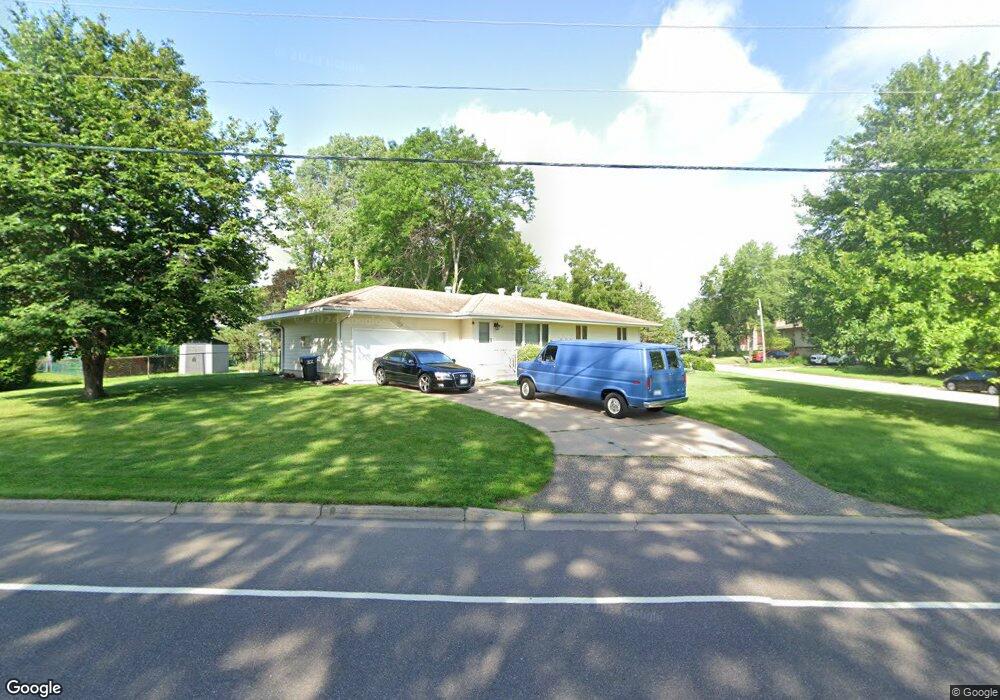
388 Centennial Dr Saint Paul, MN 55113
South Owasso NeighborhoodEstimated Value: $367,670 - $426,000
4
Beds
2
Baths
534
Sq Ft
$745/Sq Ft
Est. Value
About This Home
This home is located at 388 Centennial Dr, Saint Paul, MN 55113 and is currently estimated at $397,918, approximately $745 per square foot. 388 Centennial Dr is a home located in Ramsey County with nearby schools including Central Park Elementary School, Roseville Area Middle School, and Roseville Area Senior High School.
Ownership History
Date
Name
Owned For
Owner Type
Purchase Details
Closed on
Aug 19, 2016
Sold by
Olson Jaymes
Bought by
Chi Richard
Current Estimated Value
Home Financials for this Owner
Home Financials are based on the most recent Mortgage that was taken out on this home.
Original Mortgage
$202,000
Outstanding Balance
$92,304
Interest Rate
3.45%
Mortgage Type
New Conventional
Estimated Equity
$305,615
Purchase Details
Closed on
Nov 30, 1995
Sold by
Ryan James J and Ryan C
Bought by
Maser Norman Andrew and Maser Cheryl A
Create a Home Valuation Report for This Property
The Home Valuation Report is an in-depth analysis detailing your home's value as well as a comparison with similar homes in the area
Home Values in the Area
Average Home Value in this Area
Purchase History
| Date | Buyer | Sale Price | Title Company |
|---|---|---|---|
| Chi Richard | $263,242 | Burnet Title | |
| Maser Norman Andrew | $93,000 | -- |
Source: Public Records
Mortgage History
| Date | Status | Borrower | Loan Amount |
|---|---|---|---|
| Open | Chi Richard | $202,000 |
Source: Public Records
Tax History Compared to Growth
Tax History
| Year | Tax Paid | Tax Assessment Tax Assessment Total Assessment is a certain percentage of the fair market value that is determined by local assessors to be the total taxable value of land and additions on the property. | Land | Improvement |
|---|---|---|---|---|
| 2025 | $4,716 | $348,700 | $100,000 | $248,700 |
| 2023 | $4,716 | $339,000 | $90,000 | $249,000 |
| 2022 | $4,604 | $310,400 | $90,000 | $220,400 |
| 2021 | $3,782 | $311,600 | $85,500 | $226,100 |
| 2020 | $4,316 | $277,400 | $76,000 | $201,400 |
| 2019 | $3,750 | $294,200 | $80,000 | $214,200 |
| 2018 | $3,840 | $252,800 | $83,600 | $169,200 |
| 2017 | $3,340 | $252,000 | $83,600 | $168,400 |
| 2016 | $3,274 | $0 | $0 | $0 |
| 2015 | $3,340 | $227,800 | $89,100 | $138,700 |
| 2014 | $3,070 | $0 | $0 | $0 |
Source: Public Records
Map
Nearby Homes
- 405 Judith Ave
- 387 Iona Ln
- 2814 Matilda St
- 2970 Western Ave N
- 2720 MacKubin St
- 255 County Road C2 W
- 540 Woodhill Dr Unit 71
- 2802 Marion St
- 437 County Road C W
- 2748 Kent St
- 2687 Galtier St
- 613 S Owasso Blvd W
- 350 County Road C W
- 2730 Dale St N Unit D101
- 2730 Dale St N Unit D309
- 2720 Dale St N Unit C208
- 2710 Dale St N Unit B212
- 556 County Road C W
- 2580 Western Ave N
- 667 County Road C W
- 398 Centennial Dr
- 2843 Western Ave N
- 397 Terrace Dr
- 406 Centennial Dr
- 2856 Western Ave N
- 2848 Western Ave N
- 2864 Western Ave N
- 405 Terrace Dr
- 397 Centennial Dr
- 2840 Western Ave N
- 414 Centennial Dr
- 405 Centennial Dr
- 2874 Western Ave N
- 413 Terrace Dr
- 2834 Western Ave N
- 2857 Virginia Ave
- 388 Terrace Dr
- 2849 Virginia Ave
- 413 Centennial Dr
- 2865 Virginia Ave