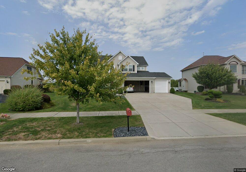
39 Avian Way Lancaster, NY 14086
Estimated Value: $587,000 - $643,000
3
Beds
3
Baths
2,331
Sq Ft
$259/Sq Ft
Est. Value
About This Home
This home is located at 39 Avian Way, Lancaster, NY 14086 and is currently estimated at $604,408, approximately $259 per square foot. 39 Avian Way is a home located in Erie County with nearby schools including William Street School, Lancaster Middle School, and Lancaster High School.
Ownership History
Date
Name
Owned For
Owner Type
Purchase Details
Closed on
Dec 31, 2018
Sold by
Matson Elliot
Bought by
Matson Elliot and Matson Sarah
Current Estimated Value
Purchase Details
Closed on
Mar 17, 2010
Sold by
Nvr Inc and Ryan Homes Of New York
Bought by
Matson Elliot
Purchase Details
Closed on
Oct 27, 2009
Sold by
The Marrano/Marc Equity Corporation
Bought by
Nvr Inc and Ryan Homes Of New York
Create a Home Valuation Report for This Property
The Home Valuation Report is an in-depth analysis detailing your home's value as well as a comparison with similar homes in the area
Home Values in the Area
Average Home Value in this Area
Purchase History
| Date | Buyer | Sale Price | Title Company |
|---|---|---|---|
| Matson Elliot | -- | None Available | |
| Matson Elliot | -- | None Available | |
| Matson Elliot | -- | None Available | |
| Matson Elliot | $294,500 | None Available | |
| Matson Elliot | $294,500 | None Available | |
| Nvr Inc | $65,000 | None Available | |
| Nvr Inc | $65,000 | None Available | |
| Nvr Inc | $65,000 | None Available |
Source: Public Records
Tax History
| Year | Tax Paid | Tax Assessment Tax Assessment Total Assessment is a certain percentage of the fair market value that is determined by local assessors to be the total taxable value of land and additions on the property. | Land | Improvement |
|---|---|---|---|---|
| 2024 | $10,184 | $372,000 | $70,000 | $302,000 |
| 2023 | $9,659 | $352,000 | $70,000 | $282,000 |
| 2022 | $9,372 | $352,000 | $70,000 | $282,000 |
| 2021 | $9,254 | $352,000 | $70,000 | $282,000 |
| 2020 | $9,758 | $352,000 | $70,000 | $282,000 |
| 2019 | $8,832 | $295,000 | $45,000 | $250,000 |
| 2018 | $9,140 | $295,000 | $45,000 | $250,000 |
| 2017 | $4,323 | $295,000 | $45,000 | $250,000 |
| 2016 | $8,857 | $295,000 | $45,000 | $250,000 |
| 2015 | -- | $295,000 | $45,000 | $250,000 |
| 2014 | -- | $295,000 | $45,000 | $250,000 |
Source: Public Records
Map
Nearby Homes
- 24 Sedge Run
- 30 Sedge Run
- 4 Fieldstream Ln
- 6 Fieldstream Ln
- 40 Fieldstream Ln
- 5502 William St
- 5924 Broadway St
- 5869 Broadway St
- 11 Cemetery Rd
- 6218 Broadway St
- 203 Siebert Rd
- 42 Worthington Ln
- 109 Grambo Dr
- 6870 Clinton St
- 14 Park Walk
- 25 Windsor Ridge Dr
- v/l William St N
- 0 V L Ransom Lot 3 Unit B1664384
- 0 V L Ransom Lot 2 Unit B1664383
- 0 V L Ransom Lot 1 Unit B1664378
Your Personal Tour Guide
Ask me questions while you tour the home.