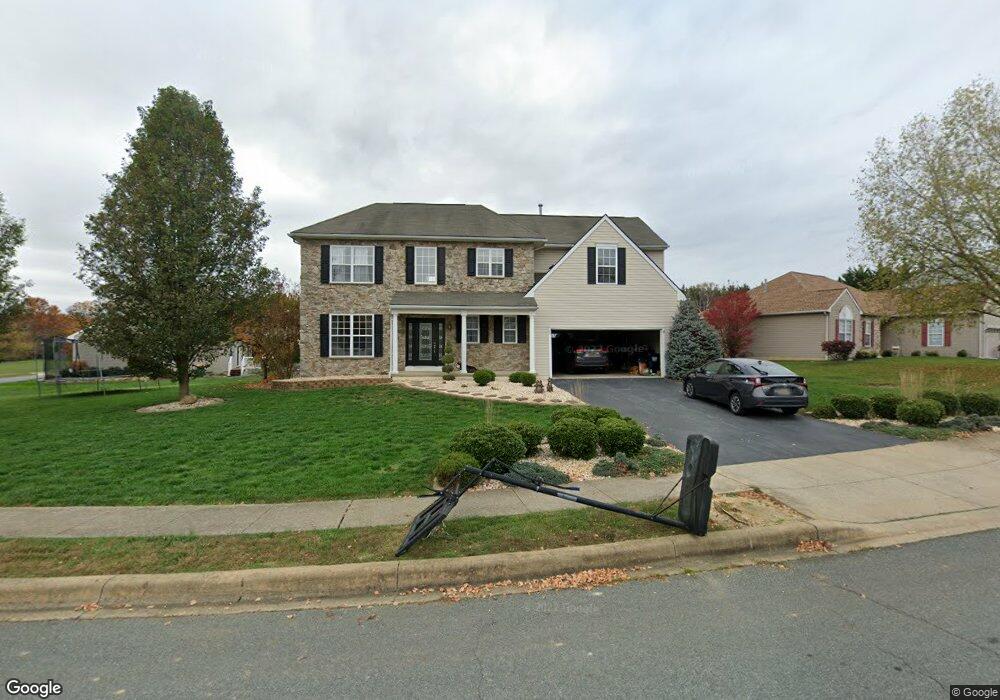
39 Silver Lake Dr Middletown, DE 19709
Estimated Value: $520,000 - $543,000
4
Beds
3
Baths
1,983
Sq Ft
$267/Sq Ft
Est. Value
About This Home
This home is located at 39 Silver Lake Dr, Middletown, DE 19709 and is currently estimated at $529,587, approximately $267 per square foot. 39 Silver Lake Dr is a home located in New Castle County with nearby schools including Silver Lake Elementary School, Everett Meredith Middle School, and Middletown High School.
Ownership History
Date
Name
Owned For
Owner Type
Purchase Details
Closed on
Dec 4, 2001
Sold by
Lakeside Development Corp
Bought by
Noto Anthony W
Current Estimated Value
Home Financials for this Owner
Home Financials are based on the most recent Mortgage that was taken out on this home.
Original Mortgage
$185,550
Outstanding Balance
$72,343
Interest Rate
6.54%
Estimated Equity
$457,244
Purchase Details
Closed on
Mar 8, 2001
Sold by
Green Richard M and Green John H
Bought by
Lakeside Development Corp
Create a Home Valuation Report for This Property
The Home Valuation Report is an in-depth analysis detailing your home's value as well as a comparison with similar homes in the area
Home Values in the Area
Average Home Value in this Area
Purchase History
| Date | Buyer | Sale Price | Title Company |
|---|---|---|---|
| Noto Anthony W | $195,352 | -- | |
| Lakeside Development Corp | $832,500 | -- |
Source: Public Records
Mortgage History
| Date | Status | Borrower | Loan Amount |
|---|---|---|---|
| Open | Noto Anthony W | $185,550 |
Source: Public Records
Tax History
| Year | Tax Paid | Tax Assessment Tax Assessment Total Assessment is a certain percentage of the fair market value that is determined by local assessors to be the total taxable value of land and additions on the property. | Land | Improvement |
|---|---|---|---|---|
| 2024 | $307 | $102,400 | $12,500 | $89,900 |
| 2023 | $307 | $102,400 | $12,500 | $89,900 |
| 2022 | $3,149 | $102,400 | $12,500 | $89,900 |
| 2021 | $3,079 | $102,400 | $12,500 | $89,900 |
| 2020 | $3,043 | $102,400 | $12,500 | $89,900 |
| 2019 | $3,127 | $102,400 | $12,500 | $89,900 |
| 2018 | $2,699 | $102,400 | $12,500 | $89,900 |
| 2017 | $2,598 | $102,400 | $12,500 | $89,900 |
| 2016 | $2,332 | $102,400 | $12,500 | $89,900 |
| 2015 | $2,419 | $102,400 | $12,500 | $89,900 |
| 2014 | $2,414 | $96,600 | $12,500 | $84,100 |
Source: Public Records
Map
Nearby Homes
- 204 Beckington Ct
- 40 S Cummings Dr
- 908 S Cass St
- Serenade Plan at Crossings at Silver Lake - Townhomes
- 809 S Scott St
- 248 Emily Way
- 8 Deep Branch Dr
- 236 E Main St
- 12 E Cochran St
- 102 Witherspoon Way
- 3002 Blackston Dr
- 104 Witherspoon Way
- 8 Redding Cir
- 106 Witherspoon Way
- 3001 Blackston Dr
- 108 Witherspoon Way
- 3008 Blackston Dr
- 114 Witherspoon Way
- 3010 Blackston Dr
- 230 Anglesey Dr
- 33 Silver Lake Dr
- 41 Silver Lake Dr
- 43 Silver Lake Dr
- 40 Silver Lake Dr
- 38 Silver Lake Dr
- 34 Silver Lake Dr
- 42 Silver Lake Dr
- 32 Silver Lake Dr
- 47 Silver Lake Dr
- 126 Lakeside Dr
- 44 Silver Lake Dr
- 30 Silver Lake Dr
- 46 Silver Lake Dr
- 48 Silver Lake Dr
- 127 Lakeside Dr
- 129 Lakeside Dr
- 134 Lakeside Dr
- 122 Lakeside Dr
- 133 Lakeside Dr
- 123 Lakeside Dr