

Estimated payment $2,421/month
Highlights
- Wood Flooring
- Porch
- Eat-In Kitchen
- Mason Intermediate Elementary School Rated A
- 2 Car Attached Garage
- Double Pane Windows
About This Home
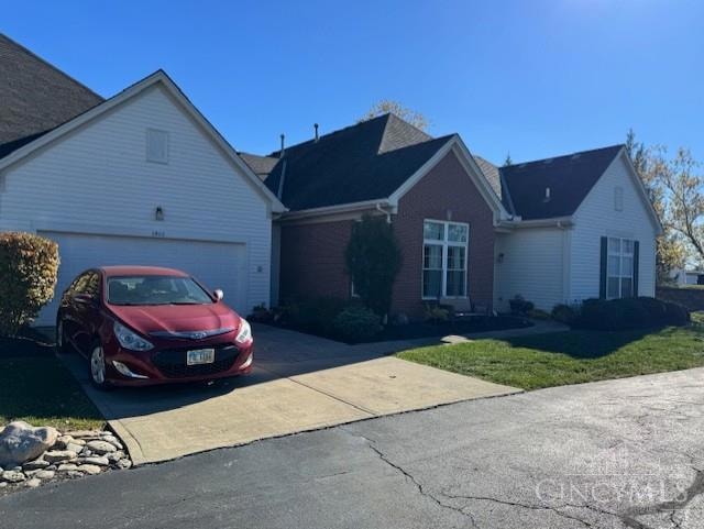
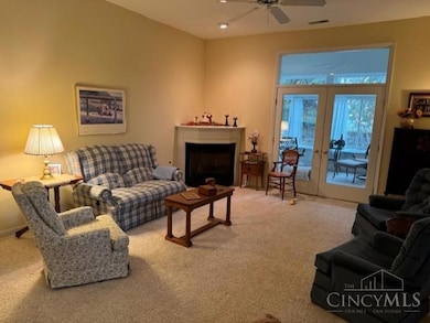
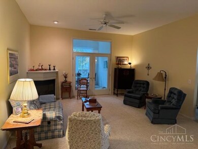
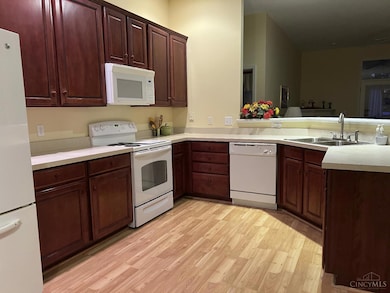
This lovely ranch condo has one floor living in the Pine Run Subdivision. This condo features 2 bedrooms and 2 full bathrooms. There are 10 Ft ceilings throughout and an open floor plan. The great room and gas fireplace. There are also There is an amazing four season room to enjoy just off the great room. The condo has a 2 car attached garage and a spacious laundry room. Enjoy the community pool. This prime location is near I-71 and shopping. The condo is move in ready waiting for your special touches. Make this Mason condo yours today.
Open House Schedule
-
Sunday, November 30, 20252:00 to 5:00 pm11/30/2025 2:00:00 PM +00:0011/30/2025 5:00:00 PM +00:00Add to Calendar
Property Details
Home Type
- Condominium
Est. Annual Taxes
- $3,966
Year Built
- Built in 2001
HOA Fees
- $353 Monthly HOA Fees
Parking
- 2 Car Attached Garage
- Front Facing Garage
- Garage Door Opener
- Driveway
- Off-Street Parking
Home Design
- Entry on the 1st floor
- Brick Exterior Construction
- Slab Foundation
- Shingle Roof
- Vinyl Siding
Interior Spaces
- 1,538 Sq Ft Home
- Property has 1 Level
- Chair Railings
- Ceiling Fan
- Recessed Lighting
- Chandelier
- Gas Fireplace
- Double Pane Windows
- Vinyl Clad Windows
- Window Treatments
- Sliding Windows
- Panel Doors
- Great Room with Fireplace
- Storage In Attic
Kitchen
- Eat-In Kitchen
- Breakfast Bar
- Oven or Range
- Microwave
- Dishwasher
- Solid Wood Cabinet
- Disposal
Flooring
- Wood
- Concrete
- Tile
Bedrooms and Bathrooms
- 2 Bedrooms
- 2 Full Bathrooms
Laundry
- Dryer
- Washer
Home Security
Outdoor Features
- Porch
Utilities
- Forced Air Heating and Cooling System
- Heating System Uses Gas
- 220 Volts
- Gas Available at Street
- Gas Water Heater
- Sewer in Street
Community Details
Overview
- Association fees include association dues, landscapingcommunity, landscaping-unit, maintenance exterior, pool, snow removal, trash
- Vertex Association
- Pine Run Subdivision
Pet Policy
- Pets Allowed
Security
- Fire and Smoke Detector
Map
Home Values in the Area
Average Home Value in this Area
Tax History
| Year | Tax Paid | Tax Assessment Tax Assessment Total Assessment is a certain percentage of the fair market value that is determined by local assessors to be the total taxable value of land and additions on the property. | Land | Improvement |
|---|---|---|---|---|
| 2024 | $3,606 | $98,640 | $29,750 | $68,890 |
| 2023 | $3,095 | $73,174 | $14,455 | $58,719 |
| 2022 | $3,055 | $73,175 | $14,455 | $58,720 |
| 2021 | $2,894 | $73,175 | $14,455 | $58,720 |
| 2020 | $2,790 | $62,013 | $12,250 | $49,763 |
| 2019 | $2,565 | $62,013 | $12,250 | $49,763 |
| 2018 | $2,574 | $62,013 | $12,250 | $49,763 |
| 2017 | $2,195 | $51,142 | $10,266 | $40,877 |
| 2016 | $2,261 | $51,142 | $10,266 | $40,877 |
| 2015 | $2,266 | $51,142 | $10,266 | $40,877 |
| 2014 | $2,290 | $48,710 | $9,780 | $38,930 |
| 2013 | $2,295 | $61,040 | $12,250 | $48,790 |
Property History
| Date | Event | Price | List to Sale | Price per Sq Ft |
|---|---|---|---|---|
| 11/06/2025 11/06/25 | For Sale | $329,900 | -- | $214 / Sq Ft |
Purchase History
| Date | Type | Sale Price | Title Company |
|---|---|---|---|
| Interfamily Deed Transfer | -- | None Available | |
| Warranty Deed | $194,000 | Classic Title | |
| Deed | $171,900 | -- |
Mortgage History
| Date | Status | Loan Amount | Loan Type |
|---|---|---|---|
| Previous Owner | $137,500 | New Conventional |
Source: MLS of Greater Cincinnati (CincyMLS)
MLS Number: 1861194
APN: 16-23-310-009
Disclaimer: Certain information contained herein is derived from information provided by parties other than Homes.com. All information provided is deemed reliable, but is not guaranteed to be accurate and should be independently verified.
![]() The data relating to real estate for sale on this website comes in part from the Broker Reciprocity programs of the MLS of Greater Cincinnati, Inc.. Those listings held by brokerage firms other than Ten-X are marked with the Broker Reciprocity logo and house icon. The properties displayed may not be all of the properties available through Broker Reciprocity.
The data relating to real estate for sale on this website comes in part from the Broker Reciprocity programs of the MLS of Greater Cincinnati, Inc.. Those listings held by brokerage firms other than Ten-X are marked with the Broker Reciprocity logo and house icon. The properties displayed may not be all of the properties available through Broker Reciprocity.
IDX information is provided exclusively for personal, non-commercial use, and may not be used for any purpose other than to identify prospective properties consumers may be interested in purchasing.
Information is deemed reliable but not guaranteed.
Ten-X does not display the entire Cincinnati MLS Broker Reciprocity™ database on this web site. The listings of some real estate brokerage firms have been excluded.
Copyright 2025, MLS of Greater Cincinnati, Inc. All rights reserved
- 6768 Pondfield Ln Unit 271E
- 6668 Pondfield Ln
- 6309 Inverness Way
- 6441 Eagleview Dr
- 6486 Prestwick Ct
- 4109 Old Manchester Ct
- 6572 Eagle View Dr
- 6674 Villager Place Unit 153D
- 3900 St Andrews Ct
- 711 Eagle View Ct
- 6565 Covefield Ct
- 6550 Villagefield Dr
- 4427 Towneside Ct
- 6545 Farmbrooke Ct
- 6788 Summer Field Dr
- 6551 Farmbrooke Ct
- 618 Bunker Ln
- 541 Wedge Way
- 4762 Flagstone Dr
- 300 Acoma Dr
- 4023 Fieldsedge Dr
- 440 David Ln
- 6671 Foxfield Dr
- 447 Lockhaven Ct
- 112 Elmlinger Dr
- 443 Lockhaven Ct
- 447 Lockhaven Ct Unit 447 Lockhaven Ct
- 7629 Watercrest Ct
- 204 Sherwood Green Ct
- 4233 N Haven Dr
- 5550 Club Park Dr
- 6389 Willow Ln
- 1009 Four Seasons Dr
- 4277 Fontenay Unit 14304
- 228 N Mason Montgomery Rd
- 4259 Spyglass Hill Unit 4259
- 4156 Spanish Bay Dr Unit 4156
- 2675 Carriagegate Ln
- 5133 Franklin Park St
- 4068 Spanish Bay Dr Unit 4068
