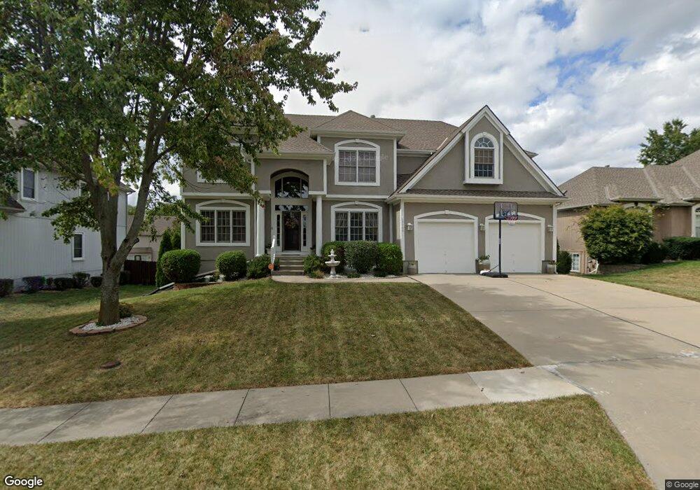
3908 SW Boulder Dr Lees Summit, MO 64082
Estimated Value: $510,000 - $595,000
4
Beds
5
Baths
3,461
Sq Ft
$160/Sq Ft
Est. Value
About This Home
This home is located at 3908 SW Boulder Dr, Lees Summit, MO 64082 and is currently estimated at $555,456, approximately $160 per square foot. 3908 SW Boulder Dr is a home located in Jackson County with nearby schools including Summit Pointe Elementary School, Summit Lakes Middle School, and Lee's Summit West High School.
Ownership History
Date
Name
Owned For
Owner Type
Purchase Details
Closed on
Jun 21, 2004
Sold by
Mcgovern Builders Inc
Bought by
Lang Bruce A and Lang Shawn P
Current Estimated Value
Home Financials for this Owner
Home Financials are based on the most recent Mortgage that was taken out on this home.
Original Mortgage
$240,000
Outstanding Balance
$117,321
Interest Rate
6%
Mortgage Type
Purchase Money Mortgage
Estimated Equity
$438,135
Create a Home Valuation Report for This Property
The Home Valuation Report is an in-depth analysis detailing your home's value as well as a comparison with similar homes in the area
Home Values in the Area
Average Home Value in this Area
Purchase History
| Date | Buyer | Sale Price | Title Company |
|---|---|---|---|
| Lang Bruce A | -- | Coffelt Land Title Inc |
Source: Public Records
Mortgage History
| Date | Status | Borrower | Loan Amount |
|---|---|---|---|
| Open | Lang Bruce A | $240,000 | |
| Closed | Lang Bruce A | $57,000 |
Source: Public Records
Tax History
| Year | Tax Paid | Tax Assessment Tax Assessment Total Assessment is a certain percentage of the fair market value that is determined by local assessors to be the total taxable value of land and additions on the property. | Land | Improvement |
|---|---|---|---|---|
| 2025 | $6,173 | $96,237 | $15,116 | $81,121 |
| 2024 | $6,128 | $85,494 | $12,217 | $73,277 |
| 2023 | $6,128 | $85,494 | $12,217 | $73,277 |
| 2022 | $5,874 | $72,770 | $8,656 | $64,114 |
| 2021 | $5,996 | $72,770 | $8,656 | $64,114 |
| 2020 | $5,770 | $69,349 | $8,656 | $60,693 |
| 2019 | $5,613 | $69,349 | $8,656 | $60,693 |
| 2018 | $5,264 | $60,356 | $7,534 | $52,822 |
| 2017 | $5,264 | $60,356 | $7,534 | $52,822 |
| 2016 | $5,106 | $57,950 | $7,182 | $50,768 |
Source: Public Records
Map
Nearby Homes
- 3916 SW Granite Ln
- 3940 SW Flintrock Dr
- 3925 SW Flintrock Dr
- 3932 SW Flintrock Dr
- 3796 SW Boulder Dr
- 3916 SW Flintrock Dr
- 3904 SW Flintrock Dr
- 3920 SW Stoney Brook Dr
- 1413 SW Whistle Dr
- 1409 SW Whistle Dr
- 4212 SW Stoney Brook Dr
- Vacant Lot 3 - SW M-150 Hwy
- 4244 SW Stoney Brook Dr
- 1505 SW Georgetown Dr
- 1009 SW Drake Cir
- 4407 SW Briarbrook Dr
- 1008 SW Whistle Dr
- 4413 SW Flintrock Dr
- 3636 SW Crane Rd
- 1524 SW 44th St
- 3904 SW Boulder Dr
- 3919 SW Granite Ln
- 3925 SW Granite Ln
- 3900 SW Boulder Dr
- 1320 SW Rylee Ln
- 4004 SW Boulder Dr
- 3909 SW Granite Ln
- 3836 SW Boulder Dr
- 1312 SW Rylee Ln
- 3905 SW Granite Ln
- 4001 SW Boulder Dr
- 1313 SW Pebble Ln
- 3912 SW Granite Ln
- 4005 SW Boulder Dr
- 3908 SW Granite Ln
- 3833 SW Boulder Dr
- 1313 SW Rylee Ln
- 3901 SW Granite Ln
- 1308 SW Rylee Ln
- 3920 SW Granite Ln
Your Personal Tour Guide
Ask me questions while you tour the home.