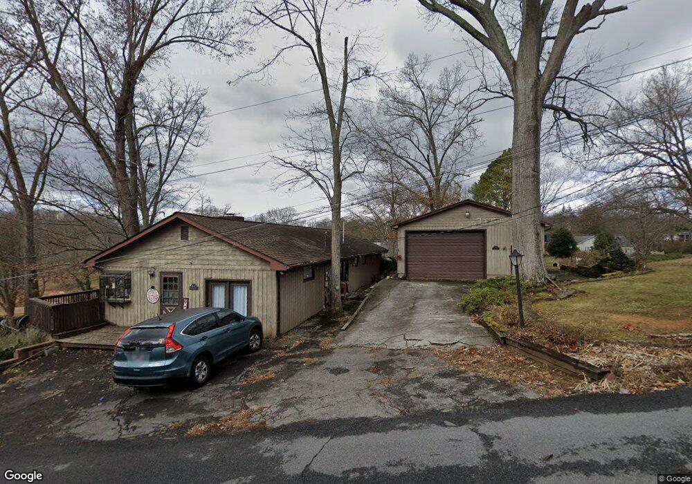
392 Center Dr Blountville, TN 37617
Estimated Value: $315,241 - $475,000
3
Beds
2
Baths
1,728
Sq Ft
$225/Sq Ft
Est. Value
About This Home
This home is located at 392 Center Dr, Blountville, TN 37617 and is currently estimated at $388,060, approximately $224 per square foot. 392 Center Dr is a home located in Sullivan County with nearby schools including Holston Elementary School, Sullivan Central Middle School, and Tri-Cities Christian Academy.
Ownership History
Date
Name
Owned For
Owner Type
Purchase Details
Closed on
Jun 12, 2006
Sold by
Wolaver Gerald F
Bought by
Amanda Haws
Current Estimated Value
Home Financials for this Owner
Home Financials are based on the most recent Mortgage that was taken out on this home.
Original Mortgage
$125,600
Outstanding Balance
$73,511
Interest Rate
6.49%
Estimated Equity
$314,549
Create a Home Valuation Report for This Property
The Home Valuation Report is an in-depth analysis detailing your home's value as well as a comparison with similar homes in the area
Home Values in the Area
Average Home Value in this Area
Purchase History
| Date | Buyer | Sale Price | Title Company |
|---|---|---|---|
| Amanda Haws | $157,000 | -- |
Source: Public Records
Mortgage History
| Date | Status | Borrower | Loan Amount |
|---|---|---|---|
| Open | Amanda Haws | $125,600 |
Source: Public Records
Tax History Compared to Growth
Tax History
| Year | Tax Paid | Tax Assessment Tax Assessment Total Assessment is a certain percentage of the fair market value that is determined by local assessors to be the total taxable value of land and additions on the property. | Land | Improvement |
|---|---|---|---|---|
| 2024 | $831 | $33,275 | $4,575 | $28,700 |
| 2023 | $801 | $33,275 | $4,575 | $28,700 |
| 2022 | $801 | $33,275 | $4,575 | $28,700 |
| 2021 | $801 | $33,275 | $4,575 | $28,700 |
| 2020 | $801 | $33,275 | $4,575 | $28,700 |
| 2019 | $801 | $31,175 | $4,575 | $26,600 |
| 2018 | $795 | $31,175 | $4,575 | $26,600 |
| 2017 | $795 | $31,175 | $4,575 | $26,600 |
| 2016 | $834 | $32,400 | $4,575 | $27,825 |
| 2014 | $747 | $32,390 | $0 | $0 |
Source: Public Records
Map
Nearby Homes
- 780 Hamilton Rd Unit 6
- 780 Hamilton Rd Unit I-4
- 1033 Haw Ridge Rd
- 225 Forest Ln N
- 145 Grande Harbor Way
- 112 Cardinal Point
- 500 Geisler Rd
- 341 Haw Ridge Rd E
- 205 Forest Ct
- 164 Forest Ln N
- 156 Forest Ln N
- 417 Cope Rd
- 148 Forest Ln S
- 290 Candy Creek Private Dr
- 412 Haw Ridge Rd E
- 205 Grande Harbor Way
- 191 Grande Harbor Way
- 411 Gammon Rd
- TBD Haw Ridge Rd
- 456 Geisler Rd
- 392 Center Dr Unit 1
- 406 Center Dr
- 380 Center Dr
- 405 Center Dr
- 374 Center Dr
- 393 Center Dr
- 411 Center Dr
- 361 Center Dr
- 360 Center Dr
- 320 Hamilton Dr
- 436 Center Dr
- 321 Barbara Dr
- LOT 18 Barbara Dr
- 325 Hamilton Dr
- 337 Barbara Dr
- 320 Barbara Dr
- 336 Hamilton Dr
- 344 Center Dr
- 335 Hamilton Dr
- 345 Center Dr