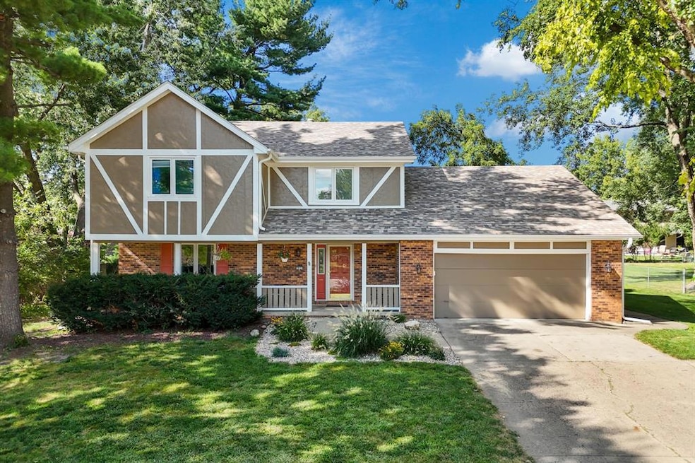
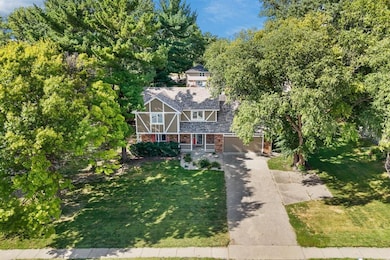
3931 Ashworth Rd West Des Moines, IA 50265
Estimated payment $2,539/month
Highlights
- Very Popular Property
- Deck
- Den
- Crossroads Park Elementary School Rated A-
- No HOA
- Shades
About This Home
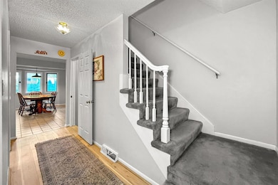
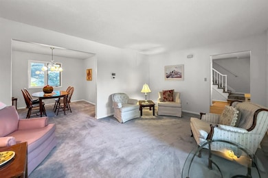
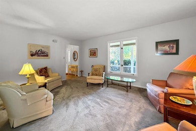
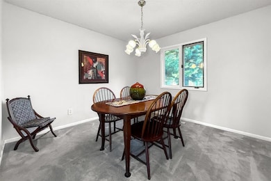
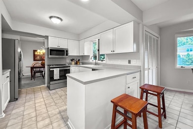
Here's a rare opportunity on Ashworth Road in West Des Moines to own this marvelous 4-bedroom 2-story with 2,849 sq. ft of finished space, including the lower level. It’s in a convenient location on an extra-deep lot with mature trees and landscaping. The entry foyer features attractive wood laminate flooring that leads to a spacious family room, open dining area, and well-designed kitchen. The family room offers a wood-burning fireplace, a flush-to-the-wall wet bar, and a sliding door to a like-new redwood deck—perfect for outdoor relaxation. The deck connects to a patio overlooking the deep backyard with trees, a utility shed, and chain-link fencing. The kitchen and dining area flow together, and there’s also a formal dining room and a living room on the main level, along with a half bath and access to the attached 2-car garage. A convenient turn-around pad provides an easy front-facing driveway exit. Upstairs, the primary bedroom includes two closets (one walk-in), a private bath with a step-in shower, and access to an upper deck. Three additional bedrooms, a full bath, and laundry complete this level. The lower level offers a large recreation room and a flex space ideal for an office or hobby area. The home has a new roof (2024) and fresh paint inside and out. Close to parks, shopping, dining, and major amenities in West Des Moines.
Home Details
Home Type
- Single Family
Est. Annual Taxes
- $5,611
Year Built
- Built in 1977
Lot Details
- 0.41 Acre Lot
- Property is zoned RS
Parking
- 2 Car Attached Garage
Home Design
- Block Foundation
- Asphalt Shingled Roof
- Cement Board or Planked
- Stucco
Interior Spaces
- 2,119 Sq Ft Home
- 2-Story Property
- Wet Bar
- Wood Burning Fireplace
- Screen For Fireplace
- Shades
- Drapes & Rods
- Family Room
- Dining Area
- Den
- Fire and Smoke Detector
- Laundry on upper level
- Finished Basement
Kitchen
- Stove
- Microwave
- Dishwasher
Flooring
- Carpet
- Laminate
- Tile
Bedrooms and Bathrooms
- 4 Bedrooms
Outdoor Features
- Deck
- Outdoor Storage
Utilities
- Central Air
- Heating System Uses Gas
- Cable TV Available
Community Details
- No Home Owners Association
Listing and Financial Details
- Assessor Parcel Number 320-02963004000
Map
Home Values in the Area
Average Home Value in this Area
Tax History
| Year | Tax Paid | Tax Assessment Tax Assessment Total Assessment is a certain percentage of the fair market value that is determined by local assessors to be the total taxable value of land and additions on the property. | Land | Improvement |
|---|---|---|---|---|
| 2025 | $5,254 | $369,000 | $71,500 | $297,500 |
| 2024 | $5,254 | $331,500 | $63,200 | $268,300 |
| 2023 | $5,212 | $331,500 | $63,200 | $268,300 |
| 2022 | $5,150 | $269,900 | $52,900 | $217,000 |
| 2021 | $4,908 | $269,900 | $52,900 | $217,000 |
| 2020 | $4,845 | $244,700 | $48,400 | $196,300 |
| 2019 | $4,606 | $244,700 | $48,400 | $196,300 |
| 2018 | $4,619 | $224,300 | $43,100 | $181,200 |
| 2017 | $4,330 | $224,300 | $43,100 | $181,200 |
| 2016 | $4,237 | $204,200 | $38,800 | $165,400 |
| 2015 | $4,222 | $204,200 | $38,800 | $165,400 |
| 2014 | $4,031 | $192,000 | $35,800 | $156,200 |
Property History
| Date | Event | Price | List to Sale | Price per Sq Ft |
|---|---|---|---|---|
| 10/06/2025 10/06/25 | Price Changed | $392,900 | -1.3% | $185 / Sq Ft |
| 09/30/2025 09/30/25 | For Sale | $397,900 | -- | $188 / Sq Ft |
Purchase History
| Date | Type | Sale Price | Title Company |
|---|---|---|---|
| Warranty Deed | $186,500 | -- |
Source: Des Moines Area Association of REALTORS®
MLS Number: 727201
APN: 320-02963004000
Disclaimer: Certain information contained herein is derived from information provided by parties other than Homes.com. All information provided is deemed reliable, but is not guaranteed to be accurate and should be independently verified.
![]() IDX information is provided exclusively for personal, non-commercial use, and may not be used for any purpose other than to identify prospective properties consumers may be interested in purchasing. Information is deemed reliable but not guaranteed.
IDX information is provided exclusively for personal, non-commercial use, and may not be used for any purpose other than to identify prospective properties consumers may be interested in purchasing. Information is deemed reliable but not guaranteed.
- 1007 Marcourt Ln
- 1019 Maplenol Dr
- 1035 Belle Mar Dr
- 3905 Francrest Dr
- 909 39th St
- 942 42nd St
- 4300 Pommel Place
- 4533 Woodland Ave Unit 2
- 4830 Cedar Dr Unit 86
- 4609 Woodland Ave Unit 5
- 1101 33rd St
- 4549 Woodland Ave Unit 4
- 1010 32nd St
- 4600 Aspen Dr
- 3204 Vine St
- 4765 Woodland Ave Unit 4
- 1112 49th St Unit 2
- 4781 Woodland Ave Unit 2
- 4849 Woodland Ave Unit 3
- 4865 Woodland Ave Unit 1
- 4101 Woodland Plaza
- 3901 Woodland Ave
- 4403 Woodland Ave
- 1340 42nd St
- 3405 Woodland Ave
- 4601 Pleasant St
- 1301 49th St
- 1200 31st St
- 312 38th St
- 4957-4949 Woodland Ave
- 4901 Pleasant St
- 3512 Maple St
- 2625 Vine St
- 4001 Ep True Pkwy
- 5250 Dakota Dr
- 5234 Boulder Dr
- 210 S 41st St
- 1101 Prairie View Dr
- 3105 Ep True Pkwy
- 4700 Ep True Pkwy
