394 Hathorne Point Rd Cushing, ME 04563
Estimated payment $14,510/month
Highlights
- Additional Residence on Property
- 394 Feet of Waterfront
- 2.5 Acre Lot
- Deeded Waterfront Access Rights
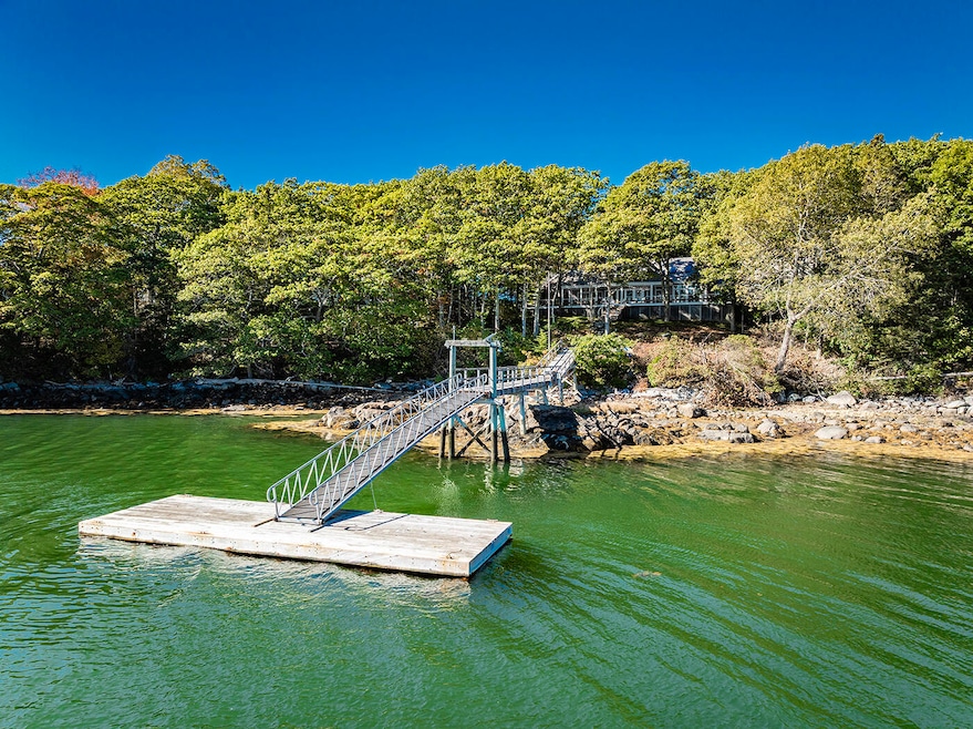
- Docks
- Deck
About This Home
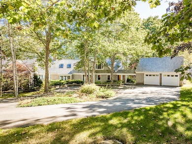
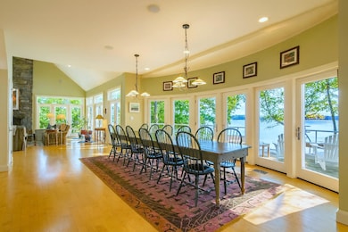
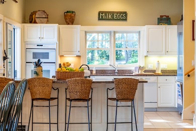
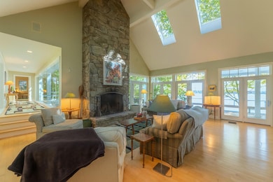
In the peaceful coastal setting of Cushing, this contemporary shingle-style home with Guest Cottage, blends architectural elegance with the timeless appeal of Maine living. With 3 bedrooms and 3.5 baths, the home is filled with natural light from high ceilings, skylights, and walls of glass. Full-light patio doors open to an expansive easterly-facing deck, where mornings begin with brilliant sunrises and sweeping water views. Evenings bring a quiet retreat, with the sound of water lapping against the shore. Whether inside or out, you can't help but feel connected to nature's calming beauty. The main house is anchored by a stately stone wood-burning fireplace, a dramatic focal point that invites both entertaining and cozy evenings by the fire. The private primary suite offers a quiet sitting nook and a spa-inspired bath with dual vanities, separate water closets, and a soaking tub, inviting relaxation. A deep-water pier and dock enhance the property's connection to a maritime lifestyle, providing effortless access for sailing, boating, or paddling at first light into Maple Juice Cove and beyond. A 2-car garage with overhead storage, joined to the home by a covered walkway, adds both function and architectural balance. As a complement to the main house, a separate 2-bedroom, 2-bath guest cottage can be accessed directly by a curved walkway or its own private driveway, offering flexibility as an extension of the main home or a private rental retreat. Centered by a large wood-burning fireplace and full kitchen, the cottage is equally refined and welcoming. Days here begin with salt air and sunlit decks, unfold with time on the water, and wind down in front of the fire, a lifestyle defined by comfort, elegance, and the enduring beauty of Maine's coast.
Listing Agent
Camden Real Estate Company Brokerage Email: info@camdenre.com Listed on: 10/01/2025
Home Details
Home Type
- Single Family
Est. Annual Taxes
- $22,643
Year Built
- Built in 2000
Lot Details
- 2.5 Acre Lot
- 394 Feet of Waterfront
- Rural Setting
- Landscaped
- Sloped Lot
- Property is zoned Shoreland
Parking
- 2 Car Attached Garage
- Parking Storage or Cabinetry
- Automatic Garage Door Opener
- Driveway
Property Views
- Water
- Scenic Vista
Home Design
- Contemporary Architecture
- Cottage
- Concrete Foundation
- Wood Frame Construction
- Shingle Roof
- Wood Roof
- Wood Siding
- Shingle Siding
- Concrete Perimeter Foundation
Interior Spaces
- 3,034 Sq Ft Home
- Built-In Features
- Cathedral Ceiling
- Skylights
- Wood Burning Fireplace
- Double Pane Windows
- Mud Room
- Living Room with Fireplace
- Dining Room
- Sink in Utility Room
- Home Security System
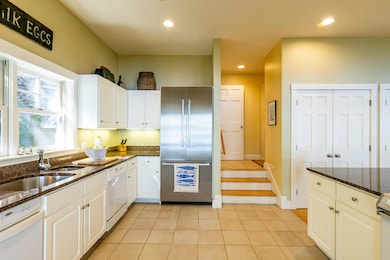
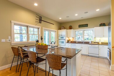
Kitchen
- Eat-In Kitchen
- Built-In Oven
- Gas Range
- Microwave
- Dishwasher
- Kitchen Island
- Granite Countertops
- Trash Compactor
Flooring
- Wood
- Carpet
- Tile
Bedrooms and Bathrooms
- 3 Bedrooms
- Main Floor Bedroom
- Primary bedroom located on second floor
- En-Suite Primary Bedroom
- En-Suite Bathroom
- Bedroom Suite
- Dual Vanity Sinks in Primary Bathroom
- Jetted Soaking Tub in Primary Bathroom
- Secondary Bathroom Jetted Tub
- Soaking Tub
- Separate Shower
Laundry
- Laundry Room
- Laundry on main level
- Dryer
- Washer
Unfinished Basement
- Basement Fills Entire Space Under The House
- Interior Basement Entry
- Crawl Space
Outdoor Features
- Deeded Waterfront Access Rights
- Deep Water Access
- Mooring
- Docks
- Balcony
- Deck
Additional Homes
- Additional Residence on Property
Utilities
- No Cooling
- Forced Air Heating System
- Heating System Uses Oil
- Baseboard Heating
- Hot Water Heating System
- Power Generator
- Private Water Source
- Well
- Electric Water Heater
- Septic Design Available
- Private Sewer
Community Details
- No Home Owners Association
Listing and Financial Details
- Tax Lot 016-1
- Assessor Parcel Number CUSH-000026-000000-000016-000001
Map
Home Values in the Area
Average Home Value in this Area
Tax History
| Year | Tax Paid | Tax Assessment Tax Assessment Total Assessment is a certain percentage of the fair market value that is determined by local assessors to be the total taxable value of land and additions on the property. | Land | Improvement |
|---|---|---|---|---|
| 2024 | $22,643 | $2,106,350 | $685,000 | $1,421,350 |
| 2023 | $22,938 | $1,433,600 | $582,030 | $851,570 |
| 2022 | $22,221 | $1,433,600 | $582,030 | $851,570 |
| 2021 | $22,364 | $1,433,600 | $582,030 | $851,570 |
| 2020 | $22,508 | $1,433,600 | $582,030 | $851,570 |
| 2019 | $1,667 | $1,433,600 | $582,030 | $851,570 |
| 2018 | $22,078 | $1,611,520 | $590,020 | $1,021,500 |
| 2017 | $20,950 | $1,611,520 | $590,020 | $1,021,500 |
Property History
| Date | Event | Price | List to Sale | Price per Sq Ft |
|---|---|---|---|---|
| 10/01/2025 10/01/25 | For Sale | $2,395,000 | -- | $789 / Sq Ft |
Purchase History
| Date | Type | Sale Price | Title Company |
|---|---|---|---|
| Deed | -- | -- | |
| Deed | -- | -- |
Mortgage History
| Date | Status | Loan Amount | Loan Type |
|---|---|---|---|
| Open | $950,000 | Adjustable Rate Mortgage/ARM | |
| Closed | $950,000 | Adjustable Rate Mortgage/ARM |
Source: Maine Listings
MLS Number: 1639010
APN: 026-016-1
Disclaimer: Certain information contained herein is derived from information provided by parties other than Homes.com. All information provided is deemed reliable, but is not guaranteed to be accurate and should be independently verified.
![]() Listing data is derived in whole or in part from Maine Real Estate Information System, Inc. (d/b/a Maine Listings) and is for consumers' personal, noncommercial use only. Dimensions are approximate and not guaranteed. All data should be independently verified.
Listing data is derived in whole or in part from Maine Real Estate Information System, Inc. (d/b/a Maine Listings) and is for consumers' personal, noncommercial use only. Dimensions are approximate and not guaranteed. All data should be independently verified.
© 2025 Maine Real Estate Information System, Inc. All Rights Reserved. Equal Housing Opportunity.
Homes.com, LLC, 17600 Laguna Canyon Rd Irvine, CA 92618 (888)-952-6393
![]()
- 253 Hathorne Point Rd
- 47 Teel Cove Rd
- 794 Pleasant Point Rd
- 576 Pleasant Point Rd
- 43 Tamarack Ln
- 211 Turkey Cove Rd
- M217 L074 Kallio Cove Rd
- M214 L23C1 Autumn Marsh Rd
- 6 Ocean Ridge Rd
- 0 Blackberry Hill Rd
- 224 Wallston Rd
- 28 Orne Ln
- Map 20 Lot 15 Rd
- 6 Glenmere Rd
- 56 Raccoon Ln
- 422 Wallston Rd
- 207 Pleasant Point Rd
- 250 Davis Point Rd
- 3 Salt Pond Rd
- 144 Woody Ln
- 7 Gilchrest St Place Unit 9
- 7 Gilchrest St Place Unit 6
- 1331 Old Rte One Unit A2
- 417 Main St
- 82 Westview Rd
- 3 Pond Rd Unit Downstairs
- 3 Pond Rd Unit Downstairs
- 236 Ocean Point Rd
- 1 Norwood Ave Unit B
- 12 Free St
- 1619 Alna Rd
- 39 Eastern Ave
- 40 Townsend Ave Unit 40 B
- 38 Townsend Ave
- 38 Townsend Ave
- 367 Gardiner Rd
- 220 Atlantic Ave
- 335 Bath Rd
- 9 Bayview Dr
- 54 Main St
