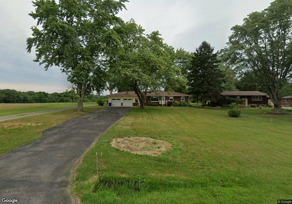
3947 Bower Rd Rootstown, OH 44272
Estimated Value: $193,977 - $241,000
3
Beds
1
Bath
1,308
Sq Ft
$164/Sq Ft
Est. Value
About This Home
This home is located at 3947 Bower Rd, Rootstown, OH 44272 and is currently estimated at $214,994, approximately $164 per square foot. 3947 Bower Rd is a home located in Portage County with nearby schools including Rootstown Middle School - Schnee Building and Rootstown High School.
Ownership History
Date
Name
Owned For
Owner Type
Purchase Details
Closed on
Oct 29, 2024
Sold by
Farah George and Farah Lisa Ann
Bought by
Rebszenko Suzanne M and Wygle Jeffrey L
Current Estimated Value
Home Financials for this Owner
Home Financials are based on the most recent Mortgage that was taken out on this home.
Original Mortgage
$104,000
Outstanding Balance
$102,527
Interest Rate
6.09%
Mortgage Type
New Conventional
Estimated Equity
$112,467
Purchase Details
Closed on
May 4, 2023
Sold by
Auth Bonnie K
Bought by
Farah George
Purchase Details
Closed on
Dec 9, 2013
Sold by
Auth Albert F and Auth Bonnie K
Bought by
Auth Albert F and Auth Bonnie K
Purchase Details
Closed on
Nov 21, 1985
Bought by
Auth Albert F and Auth Bonnie K
Create a Home Valuation Report for This Property
The Home Valuation Report is an in-depth analysis detailing your home's value as well as a comparison with similar homes in the area
Purchase History
| Date | Buyer | Sale Price | Title Company |
|---|---|---|---|
| Rebszenko Suzanne M | $130,000 | Infinity Title | |
| Farah George | -- | None Listed On Document | |
| Auth Albert F | -- | None Available | |
| Auth Albert F | $65,000 | -- |
Source: Public Records
Mortgage History
| Date | Status | Borrower | Loan Amount |
|---|---|---|---|
| Open | Rebszenko Suzanne M | $104,000 |
Source: Public Records
Tax History
| Year | Tax Paid | Tax Assessment Tax Assessment Total Assessment is a certain percentage of the fair market value that is determined by local assessors to be the total taxable value of land and additions on the property. | Land | Improvement |
|---|---|---|---|---|
| 2025 | $2,806 | $77,250 | $9,210 | $68,040 |
| 2024 | $3,163 | $77,250 | $9,210 | $68,040 |
| 2023 | $2,636 | $57,340 | $8,090 | $49,250 |
| 2022 | $2,167 | $57,340 | $8,090 | $49,250 |
| 2021 | $2,164 | $57,340 | $8,090 | $49,250 |
| 2020 | $1,883 | $49,420 | $7,700 | $41,720 |
| 2019 | $1,889 | $49,420 | $7,700 | $41,720 |
| 2018 | $1,657 | $42,530 | $8,190 | $34,340 |
| 2017 | $1,657 | $42,530 | $8,190 | $34,340 |
| 2016 | $2,040 | $42,530 | $8,190 | $34,340 |
| 2015 | $2,064 | $42,530 | $8,190 | $34,340 |
| 2014 | $2,207 | $42,530 | $8,190 | $34,340 |
| 2013 | $2,087 | $42,530 | $8,190 | $34,340 |
Source: Public Records
Map
Nearby Homes
- 3701 State Route 44
- 3689 Cherry Hill
- 4079 Siefer Dr
- 3637 Old Forge Rd
- 3021 Hartville Rd
- V/L 2 Lynn Rd
- V/L Lynn Rd
- 3981 Marsh Creek Ln Unit 37
- 4556 Rootstown Rd
- 4200 Hattrick Rd
- 4415 Farmette Dr
- 3080 Saxe Rd
- sub lot Lane Ave
- 4140 Sandy Lake Rd
- 4184 Hunters Ridge Dr
- 3583 Randolph Rd
- 4958 Bassett Rd
- 2978 Sandy Lake Rd
- 4058 Bayberry Knoll Ln
- 2326 Orchard Cir
Your Personal Tour Guide
Ask me questions while you tour the home.