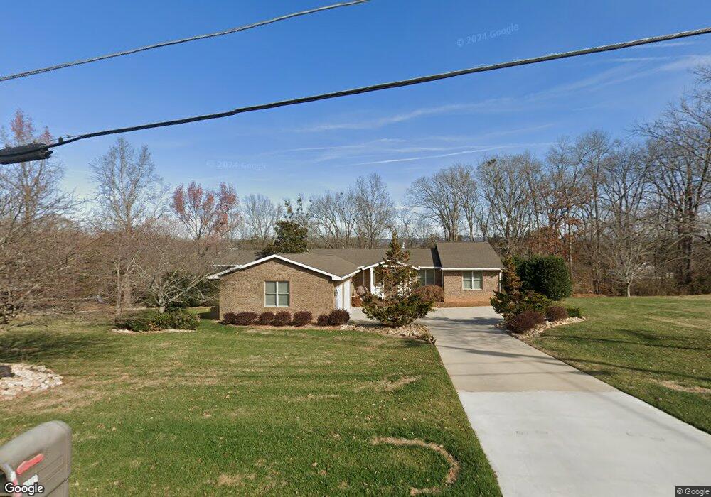
397 Shadowbrook Rd Winchester, TN 37398
Estimated Value: $632,000 - $834,000
--
Bed
5
Baths
4,127
Sq Ft
$173/Sq Ft
Est. Value
About This Home
This home is located at 397 Shadowbrook Rd, Winchester, TN 37398 and is currently estimated at $714,241, approximately $173 per square foot. 397 Shadowbrook Rd is a home located in Franklin County with nearby schools including South Middle School, Franklin County High School, and Winchester Christian Academy.
Ownership History
Date
Name
Owned For
Owner Type
Purchase Details
Closed on
Sep 2, 1999
Sold by
Warren George T Trust
Bought by
Mason Roy and Mason Carolyn
Current Estimated Value
Purchase Details
Closed on
Aug 27, 1998
Sold by
Greer Patrick R
Bought by
Warren George T Trust
Purchase Details
Closed on
Jun 16, 1991
Bought by
Greer Patrick R and Greer Rebecca
Purchase Details
Closed on
Apr 4, 1985
Bought by
Mccord Mccord J and Mccord Nancy L
Purchase Details
Closed on
Dec 15, 1977
Create a Home Valuation Report for This Property
The Home Valuation Report is an in-depth analysis detailing your home's value as well as a comparison with similar homes in the area
Home Values in the Area
Average Home Value in this Area
Purchase History
| Date | Buyer | Sale Price | Title Company |
|---|---|---|---|
| Mason Roy | $26,968 | -- | |
| Warren George T Trust | $25,000 | -- | |
| Greer Patrick R | $21,000 | -- | |
| Mccord Mccord J | -- | -- | |
| -- | -- | -- |
Source: Public Records
Tax History Compared to Growth
Tax History
| Year | Tax Paid | Tax Assessment Tax Assessment Total Assessment is a certain percentage of the fair market value that is determined by local assessors to be the total taxable value of land and additions on the property. | Land | Improvement |
|---|---|---|---|---|
| 2024 | $4,684 | $182,175 | $12,225 | $169,950 |
| 2023 | $4,684 | $182,175 | $12,225 | $169,950 |
| 2022 | $4,593 | $182,175 | $12,225 | $169,950 |
| 2021 | $3,170 | $182,175 | $12,225 | $169,950 |
| 2020 | $4,375 | $123,775 | $12,575 | $111,200 |
| 2019 | $4,375 | $123,775 | $12,575 | $111,200 |
| 2018 | $4,121 | $123,775 | $12,575 | $111,200 |
| 2017 | $4,121 | $123,775 | $12,575 | $111,200 |
| 2016 | $3,924 | $117,875 | $11,300 | $106,575 |
| 2015 | $3,853 | $117,875 | $11,300 | $106,575 |
| 2014 | $3,853 | $117,878 | $0 | $0 |
Source: Public Records
Map
Nearby Homes
- 630 Shadowbrook Rd
- 0 S College St Unit RTC2942332
- 144 Wood Bluff Rd
- 309 Woodcrest Dr
- 0 Deer Valley Cir Unit RTC2980817
- 0 Deer Valley Cir Unit RTC2980816
- 0 Deer Valley Cir Unit RTC2980815
- 0 Deer Valley Cir Unit RTC2980813
- 0 Deer Valley Cir Unit RTC2980812
- 0 Deer Valley Cir Unit RTC2980811
- 0 Deer Valley Cir Unit RTC2980810
- 0 Deer Valley Cir Unit RTC2980808
- 0 Deer Valley Cir Unit RTC2980805
- 0 Deer Valley Cir Unit RTC2980803
- 0 Deer Valley Cir Unit RTC2980802
- 0 Deer Valley Cir Unit RTC2980801
- 0 Deer Valley Cir Unit RTC2980798
- 0 Deer Valley Cir Unit RTC2980797
- 0 Deer Valley Cir Unit RTC2980794
- 0 Deer Valley Cir Unit RTC2980792
- 355 Shadowbrook Rd
- 445 Shadowbrook Rd
- 396 Shadowbrook Rd
- 168 Old Mill Rd
- 364 Shadowbrook Rd
- 434 Shadowbrook Rd
- 208 Old Mill Rd
- 301 Shadowbrook Rd
- 234 Old Mill Rd
- 1894 Cowan Hwy
- 219 Old Mill Rd
- 260 Old Mill Rd
- 491 Shadowbrook Rd
- 2030 Cowan Hwy
- 494 Shadowbrook Rd
- 3 Old Mill Rd
- 241 Shadowbrook Rd
- 242 Shadowbrook Rd
- 2020 Cowan Hwy
- 574 Shadowbrook Rd