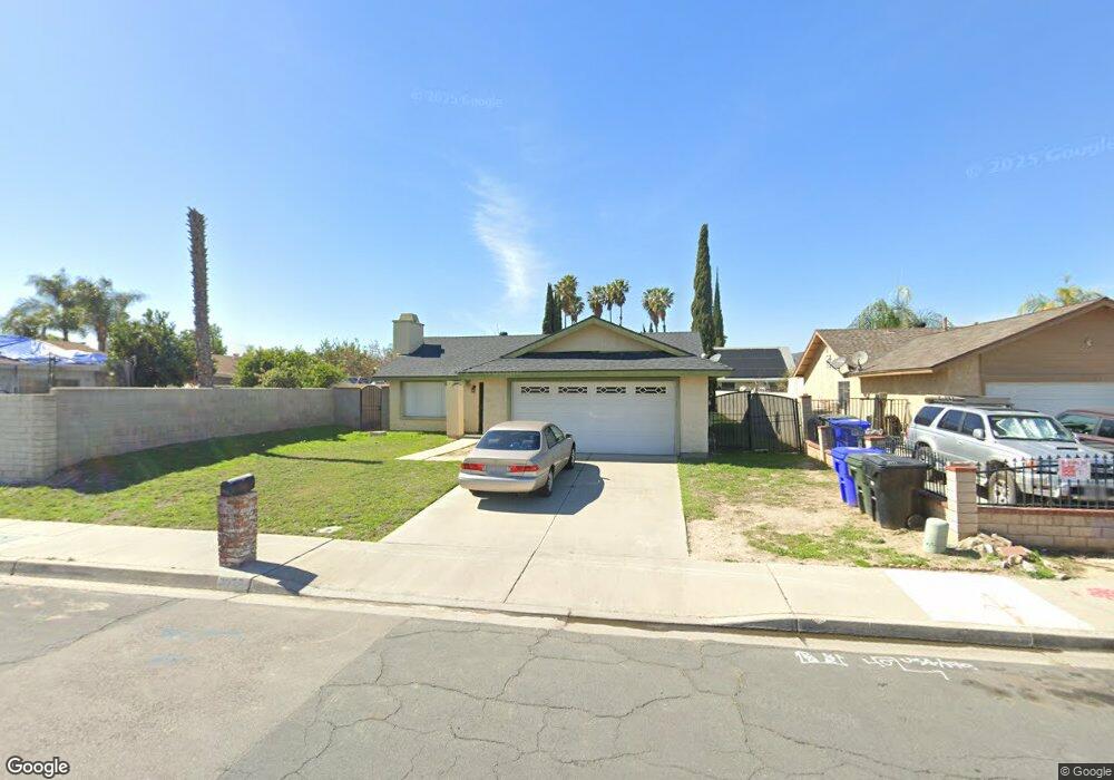
3977 Driving Range Rd Riverside, CA 92509
Rubidoux NeighborhoodEstimated Value: $473,357 - $554,000
3
Beds
2
Baths
1,260
Sq Ft
$414/Sq Ft
Est. Value
About This Home
This home is located at 3977 Driving Range Rd, Riverside, CA 92509 and is currently estimated at $521,589, approximately $413 per square foot. 3977 Driving Range Rd is a home located in Riverside County with nearby schools including Peralta Elementary, Mission Middle School, and Rubidoux High School.
Ownership History
Date
Name
Owned For
Owner Type
Purchase Details
Closed on
Apr 17, 2008
Sold by
Zamora Neptali and Zamora Rachel
Bought by
Zamora Manuel and Zamora Natalie
Current Estimated Value
Purchase Details
Closed on
Mar 15, 1996
Sold by
Hud
Bought by
Zamora Neptali and Zamora Rachael
Purchase Details
Closed on
Mar 14, 1995
Sold by
Midfirst Bank
Bought by
Hud
Purchase Details
Closed on
Feb 15, 1995
Sold by
Roper Jeffrey L and Roper Daria A
Bought by
Midfirst Bank
Create a Home Valuation Report for This Property
The Home Valuation Report is an in-depth analysis detailing your home's value as well as a comparison with similar homes in the area
Home Values in the Area
Average Home Value in this Area
Purchase History
| Date | Buyer | Sale Price | Title Company |
|---|---|---|---|
| Zamora Manuel | -- | None Available | |
| Zamora Neptali | $46,500 | Stewart Title Company | |
| Hud | -- | World Title Company | |
| Midfirst Bank | $87,761 | World Title Company |
Source: Public Records
Tax History
| Year | Tax Paid | Tax Assessment Tax Assessment Total Assessment is a certain percentage of the fair market value that is determined by local assessors to be the total taxable value of land and additions on the property. | Land | Improvement |
|---|---|---|---|---|
| 2025 | $929 | $77,208 | $49,818 | $27,390 |
| 2023 | $911 | $74,212 | $47,885 | $26,327 |
| 2022 | $895 | $72,758 | $46,947 | $25,811 |
| 2021 | $894 | $71,332 | $46,027 | $25,305 |
| 2020 | $884 | $70,602 | $45,556 | $25,046 |
| 2019 | $866 | $69,218 | $44,663 | $24,555 |
| 2018 | $839 | $67,862 | $43,788 | $24,074 |
| 2017 | $830 | $66,532 | $42,930 | $23,602 |
| 2016 | $819 | $65,229 | $42,089 | $23,140 |
| 2015 | $808 | $64,251 | $41,457 | $22,794 |
| 2014 | $757 | $62,995 | $40,646 | $22,349 |
Source: Public Records
Map
Nearby Homes
- 3825 Crestmore Rd Unit 414
- 3825 Crestmore Rd Unit 494
- 3825 Crestmore Rd Unit 378
- 3825 Crestmore Rd Unit 475
- 3825 Crestmore Rd Unit 480
- 5442 Mission Blvd
- 5184 Westerfield St
- 3895 Twining St
- 0 Odell St
- 3830 Crestmore Rd Unit 503
- 5342 36th St
- 3747 Mintern St
- 5315 Wenatchee Way
- 3934 Pontiac Ave
- 5479 34th St
- 0 Mission Blvd Unit IG25268475
- 0 Mission Blvd Unit PW25275749
- 0 Mission Blvd Unit IV23139894
- 5748 Tilton Ave
- 5754 Tilton Ave
- 3967 Driving Range Rd
- 5323 Capary Rd
- 5335 Capary Rd
- 5346 Bogie Ct
- 5345 Capary Rd
- 5358 Bogie Ct
- 3976 Driving Range Rd
- 3947 Driving Range Rd
- 3986 Driving Range Rd
- 5357 Capary Rd
- 3966 Driving Range Rd
- 3996 Driving Range Rd
- 3956 Driving Range Rd
- 5368 Bogie Ct
- 5367 Capary Rd
- 5345 Bogie Ct
- 3937 Driving Range Rd
- 3946 Driving Range Rd
- 5369 Bogie Ct
- 5357 Bogie Ct
Your Personal Tour Guide
Ask me questions while you tour the home.