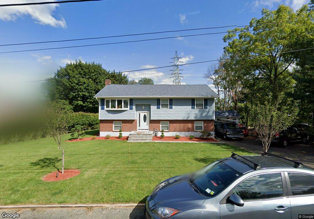
4 Cinder Rd Garnerville, NY 10923
Estimated Value: $476,000 - $616,000
4
Beds
2
Baths
1,164
Sq Ft
$493/Sq Ft
Est. Value
About This Home
This home is located at 4 Cinder Rd, Garnerville, NY 10923 and is currently estimated at $573,297, approximately $492 per square foot. 4 Cinder Rd is a home located in Rockland County with nearby schools including West Haverstraw Elementary School, Haverstraw Elementary School, and Fieldstone Secondary School.
Ownership History
Date
Name
Owned For
Owner Type
Purchase Details
Closed on
May 22, 2025
Sold by
Marroquin Donis Raul Aguilar and Lima Victor Raul
Bought by
Aguilar Trust
Current Estimated Value
Purchase Details
Closed on
Jan 19, 2018
Sold by
Deutsche Bank National Trust Co
Bought by
Aguilar Marroquin Donis R and Aguilar Lima Victor
Purchase Details
Closed on
Jun 12, 2017
Sold by
Torres Nestali and Torres Ligia C
Bought by
Deutsche Bank National Trust Company
Purchase Details
Closed on
Apr 4, 2002
Sold by
Torres Nestali
Bought by
Torres Nestali and Torres Ligia Cruz
Home Financials for this Owner
Home Financials are based on the most recent Mortgage that was taken out on this home.
Original Mortgage
$226,400
Interest Rate
7.75%
Mortgage Type
Purchase Money Mortgage
Create a Home Valuation Report for This Property
The Home Valuation Report is an in-depth analysis detailing your home's value as well as a comparison with similar homes in the area
Home Values in the Area
Average Home Value in this Area
Purchase History
| Date | Buyer | Sale Price | Title Company |
|---|---|---|---|
| Aguilar Trust | -- | None Available | |
| Aguilar Marroquin Donis R | $253,008 | Judicial Title | |
| Deutsche Bank National Trust Company | $533,512 | None Available | |
| Torres Nestali | -- | Stewart Title | |
| Torres Nestali | -- | Stewart Title | |
| Torres Nestali | -- | Stewart Title |
Source: Public Records
Mortgage History
| Date | Status | Borrower | Loan Amount |
|---|---|---|---|
| Previous Owner | Torres Nestali | $226,400 |
Source: Public Records
Tax History
| Year | Tax Paid | Tax Assessment Tax Assessment Total Assessment is a certain percentage of the fair market value that is determined by local assessors to be the total taxable value of land and additions on the property. | Land | Improvement |
|---|---|---|---|---|
| 2024 | $20,393 | $265,800 | $100,600 | $165,200 |
| 2023 | $20,393 | $265,800 | $100,600 | $165,200 |
| 2022 | $4,313 | $265,800 | $100,600 | $165,200 |
| 2021 | $20,167 | $265,800 | $100,600 | $165,200 |
| 2020 | $15,752 | $265,800 | $100,600 | $165,200 |
| 2019 | $13,574 | $265,800 | $100,600 | $165,200 |
| 2018 | $22,800 | $265,800 | $100,600 | $165,200 |
| 2017 | $12,280 | $265,800 | $100,600 | $165,200 |
| 2016 | $21,567 | $265,800 | $100,600 | $165,200 |
| 2015 | -- | $265,800 | $100,600 | $165,200 |
| 2014 | -- | $265,800 | $100,600 | $165,200 |
Source: Public Records
Map
Nearby Homes
Your Personal Tour Guide
Ask me questions while you tour the home.