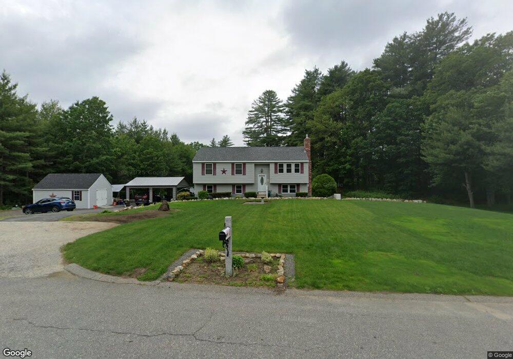
4 Winthrop Rd Londonderry, NH 03053
Estimated Value: $522,000 - $569,000
3
Beds
3
Baths
1,132
Sq Ft
$478/Sq Ft
Est. Value
About This Home
This home is located at 4 Winthrop Rd, Londonderry, NH 03053 and is currently estimated at $540,584, approximately $477 per square foot. 4 Winthrop Rd is a home with nearby schools including Matthew Thornton Elementary School, Londonderry Middle School, and Londonderry Senior High School.
Ownership History
Date
Name
Owned For
Owner Type
Purchase Details
Closed on
Feb 17, 2015
Sold by
Debye Michelle
Bought by
Paul&Michelle Debye Ft and Debye Paul L
Current Estimated Value
Purchase Details
Closed on
May 10, 2006
Sold by
Lessman William H
Bought by
Lavalle Albert J
Purchase Details
Closed on
Jun 1, 2001
Sold by
Legacy Joseph R and Legacy Barbara A
Bought by
Lessmann William H and Lessmann Sandra L
Home Financials for this Owner
Home Financials are based on the most recent Mortgage that was taken out on this home.
Original Mortgage
$167,900
Interest Rate
7.09%
Purchase Details
Closed on
May 16, 1997
Sold by
Smith Nelson E and Smith Kethleen M
Bought by
Lagacy Joseph R and Lagacy Barbara A
Home Financials for this Owner
Home Financials are based on the most recent Mortgage that was taken out on this home.
Original Mortgage
$111,912
Interest Rate
8.12%
Create a Home Valuation Report for This Property
The Home Valuation Report is an in-depth analysis detailing your home's value as well as a comparison with similar homes in the area
Home Values in the Area
Average Home Value in this Area
Purchase History
| Date | Buyer | Sale Price | Title Company |
|---|---|---|---|
| Paul&Michelle Debye Ft | -- | -- | |
| Lavalle Albert J | $279,000 | -- | |
| Lessmann William H | $210,000 | -- | |
| Lagacy Joseph R | $112,000 | -- |
Source: Public Records
Mortgage History
| Date | Status | Borrower | Loan Amount |
|---|---|---|---|
| Previous Owner | Lagacy Joseph R | $167,900 | |
| Previous Owner | Lagacy Joseph R | $111,912 |
Source: Public Records
Tax History Compared to Growth
Tax History
| Year | Tax Paid | Tax Assessment Tax Assessment Total Assessment is a certain percentage of the fair market value that is determined by local assessors to be the total taxable value of land and additions on the property. | Land | Improvement |
|---|---|---|---|---|
| 2024 | $7,671 | $475,300 | $223,000 | $252,300 |
| 2023 | $7,457 | $476,500 | $223,000 | $253,500 |
| 2022 | $7,185 | $388,800 | $168,300 | $220,500 |
| 2021 | $7,146 | $388,800 | $168,300 | $220,500 |
| 2020 | $7,107 | $353,400 | $132,600 | $220,800 |
| 2019 | $6,852 | $353,400 | $132,600 | $220,800 |
| 2018 | $6,150 | $282,100 | $111,700 | $170,400 |
| 2017 | $6,096 | $282,100 | $111,700 | $170,400 |
| 2016 | $6,065 | $282,100 | $111,700 | $170,400 |
| 2015 | $5,930 | $282,100 | $111,700 | $170,400 |
| 2014 | $5,949 | $282,100 | $111,700 | $170,400 |
| 2011 | -- | $281,600 | $111,700 | $169,900 |
Source: Public Records
Map
Nearby Homes
- 4 Quincy Rd Unit A
- 15 Alan Cir
- 10 Jason Dr
- 20 Locke Mill Dr
- 19 Dixon Dr
- 13 Moose Hollow Rd
- 9 High Range Rd
- 4 Bayberry Ln
- 12 Wiley Hill Rd
- 12 Louise Dr
- 22 Cardinal Ln
- 6 Wiley Hill Rd
- 4 Delphi Way
- 1 Delphi Way
- 1 Delphi Way Unit 10
- 5 Delphi Way
- 3 Delphi Way
- 7 Delphi Way
- 88 High Range Rd
- 90 High Range Rd