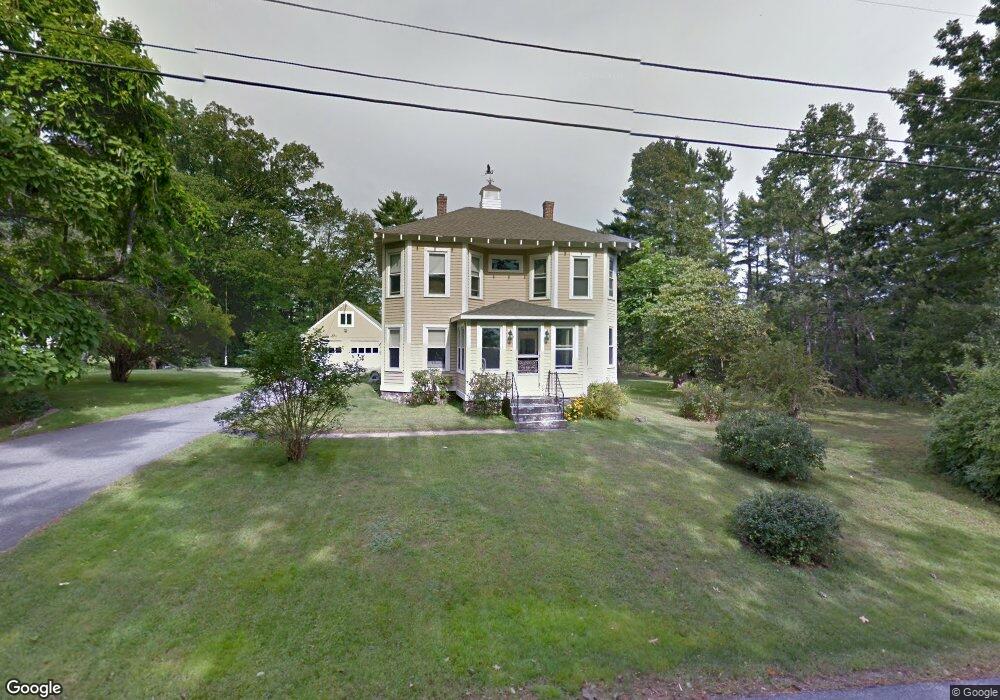
40 Fernald Ave York, ME 03909
York Harbor NeighborhoodEstimated Value: $742,598 - $920,000
4
Beds
1
Bath
2,350
Sq Ft
$365/Sq Ft
Est. Value
About This Home
This home is located at 40 Fernald Ave, York, ME 03909 and is currently estimated at $857,650, approximately $364 per square foot. 40 Fernald Ave is a home located in York County with nearby schools including Coastal Ridge Elementary School, Village Elementary School, and York Middle School.
Ownership History
Date
Name
Owned For
Owner Type
Purchase Details
Closed on
Jan 23, 2020
Sold by
Gallant Lisa M
Bought by
Gallant Paul H and Gallant Lisa M
Current Estimated Value
Create a Home Valuation Report for This Property
The Home Valuation Report is an in-depth analysis detailing your home's value as well as a comparison with similar homes in the area
Home Values in the Area
Average Home Value in this Area
Purchase History
| Date | Buyer | Sale Price | Title Company |
|---|---|---|---|
| Gallant Paul H | -- | None Available |
Source: Public Records
Tax History Compared to Growth
Tax History
| Year | Tax Paid | Tax Assessment Tax Assessment Total Assessment is a certain percentage of the fair market value that is determined by local assessors to be the total taxable value of land and additions on the property. | Land | Improvement |
|---|---|---|---|---|
| 2024 | $5,400 | $642,900 | $276,500 | $366,400 |
| 2023 | $5,208 | $616,300 | $253,500 | $362,800 |
| 2022 | $4,720 | $552,000 | $228,500 | $323,500 |
| 2021 | $4,772 | $479,600 | $214,000 | $265,600 |
| 2020 | $4,129 | $397,000 | $181,100 | $215,900 |
| 2019 | $4,427 | $397,000 | $181,100 | $215,900 |
| 2018 | $1,971 | $370,600 | $154,700 | $215,900 |
| 2017 | $3,540 | $323,300 | $148,100 | $175,200 |
| 2016 | $3,201 | $287,100 | $111,900 | $175,200 |
| 2015 | $3,158 | $287,100 | $111,900 | $175,200 |
| 2014 | $3,072 | $287,100 | $111,900 | $175,200 |
| 2013 | $2,789 | $267,400 | $92,200 | $175,200 |
Source: Public Records
Map
Nearby Homes
- 208 Long Sands Rd
- 294 York St Unit 1
- 294 York St Unit 2
- 294 York St Unit 3
- 281 York St
- 60 Barrell Ln Unit 3
- 60 Barrell Ln Unit 1
- 425 York St
- 419 & 425 York St
- 15 Summer Breeze Unit A & B
- 3 Sentry Hill Rd
- 2 Roaring Rock Rd
- 23 Harmon Park Rd
- 361 Long Beach Ave
- 8 Roaring Rock Rd
- 801 Us Rt 1 Yorke Woods Unit K-3
- 589 York St Unit 11
- 23 Kerry Rd
- 6 Dingle Rd Unit 4
- 6 Dingle Rd Unit 5