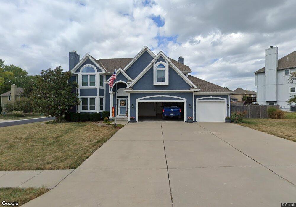
4004 SW Boulder Dr Lees Summit, MO 64082
Estimated Value: $500,000 - $545,000
4
Beds
4
Baths
2,913
Sq Ft
$177/Sq Ft
Est. Value
About This Home
This home is located at 4004 SW Boulder Dr, Lees Summit, MO 64082 and is currently estimated at $516,404, approximately $177 per square foot. 4004 SW Boulder Dr is a home located in Jackson County with nearby schools including Summit Pointe Elementary School, Summit Lakes Middle School, and Lee's Summit West High School.
Ownership History
Date
Name
Owned For
Owner Type
Purchase Details
Closed on
Jan 9, 2007
Sold by
Us Bank Na
Bought by
Lounsberry David B and Lounsberry Jeannette
Current Estimated Value
Home Financials for this Owner
Home Financials are based on the most recent Mortgage that was taken out on this home.
Original Mortgage
$159,000
Outstanding Balance
$94,435
Interest Rate
6.1%
Mortgage Type
Purchase Money Mortgage
Estimated Equity
$421,969
Purchase Details
Closed on
Mar 3, 2004
Sold by
Mcgovern Builders Inc
Bought by
Shelby Vincent and Shelby Jamesetta
Home Financials for this Owner
Home Financials are based on the most recent Mortgage that was taken out on this home.
Original Mortgage
$225,640
Interest Rate
8.13%
Mortgage Type
Purchase Money Mortgage
Create a Home Valuation Report for This Property
The Home Valuation Report is an in-depth analysis detailing your home's value as well as a comparison with similar homes in the area
Home Values in the Area
Average Home Value in this Area
Purchase History
| Date | Buyer | Sale Price | Title Company |
|---|---|---|---|
| Lounsberry David B | -- | First American Title | |
| Shelby Vincent | -- | Coffelt Land Title Inc |
Source: Public Records
Mortgage History
| Date | Status | Borrower | Loan Amount |
|---|---|---|---|
| Open | Lounsberry David B | $159,000 | |
| Previous Owner | Shelby Vincent | $225,640 | |
| Closed | Shelby Vincent | $56,410 |
Source: Public Records
Tax History Compared to Growth
Tax History
| Year | Tax Paid | Tax Assessment Tax Assessment Total Assessment is a certain percentage of the fair market value that is determined by local assessors to be the total taxable value of land and additions on the property. | Land | Improvement |
|---|---|---|---|---|
| 2025 | $6,448 | $83,424 | $16,821 | $66,603 |
| 2024 | $6,401 | $89,300 | $15,878 | $73,422 |
| 2023 | $6,401 | $89,300 | $15,878 | $73,422 |
| 2022 | $5,092 | $63,080 | $7,975 | $55,105 |
| 2021 | $5,198 | $63,080 | $7,975 | $55,105 |
| 2020 | $5,242 | $63,003 | $7,975 | $55,028 |
| 2019 | $5,099 | $63,003 | $7,975 | $55,028 |
| 2018 | $4,782 | $54,833 | $6,941 | $47,892 |
| 2017 | $4,704 | $54,833 | $6,941 | $47,892 |
| 2016 | $4,704 | $53,390 | $7,581 | $45,809 |
| 2014 | $4,720 | $52,509 | $7,076 | $45,433 |
Source: Public Records
Map
Nearby Homes
- 1520 SW 41st St
- 3940 SW Flintrock Dr
- 3932 SW Flintrock Dr
- 3925 SW Flintrock Dr
- Serenade Plan at Stoney Creek - Bliss Collection
- Oasis Plan at Stoney Creek - Bliss Collection
- Devotion Plan at Stoney Creek - Bliss Collection
- Brookside Plan at Stoney Creek - Premier Collection
- Serenity Plan at Stoney Creek - Bliss Collection
- Avalon Plan at Stoney Creek - Premier Collection
- Harmony Plan at Stoney Creek - Bliss Collection
- 1937 SW Merryman Dr
- Lexington Plan at Stoney Creek - Premier Collection
- Crestwood Plan at Stoney Creek - Premier Collection
- 4104 SW Flintrock Dr
- 3917 SW Flintrock Dr
- Heather Plan at Napa Valley
- 3916 SW Flintrock Dr
- 4120 SW Flintrock Dr
- 3904 SW Flintrock Dr
- 3925 SW Granite Ln
- 4005 SW Boulder Dr
- 4001 SW Boulder Dr
- 4002 SW Granite Ln
- 3908 SW Boulder Dr
- 3919 SW Granite Ln
- 4006 SW Granite Ln
- 1320 SW Rylee Ln
- 3924 SW Granite Ln
- 4015 SW Granite Ln
- 3904 SW Boulder Dr
- 3920 SW Granite Ln
- 1313 SW Rylee Ln
- 3916 SW Granite Ln
- 4014 SW Granite Ln
- 1312 SW Rylee Ln
- 4019 SW Granite Ln
- 3909 SW Granite Ln
- 3912 SW Granite Ln
- 3900 SW Boulder Dr