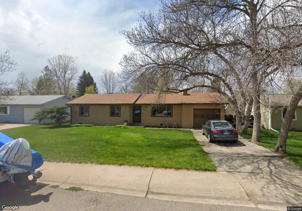
401 Irish Dr Fort Collins, CO 80521
Estimated Value: $474,870 - $529,000
3
Beds
2
Baths
1,180
Sq Ft
$426/Sq Ft
Est. Value
About This Home
This home is located at 401 Irish Dr, Fort Collins, CO 80521 and is currently estimated at $502,218, approximately $425 per square foot. 401 Irish Dr is a home located in Larimer County with nearby schools including Irish Elementary School, Lincoln Middle School, and Poudre High School.
Ownership History
Date
Name
Owned For
Owner Type
Purchase Details
Closed on
Oct 28, 2011
Sold by
Spirek Susan Gail Miller
Bought by
Spirek Ray
Current Estimated Value
Home Financials for this Owner
Home Financials are based on the most recent Mortgage that was taken out on this home.
Original Mortgage
$30,000
Interest Rate
3.99%
Mortgage Type
Purchase Money Mortgage
Purchase Details
Closed on
Sep 30, 1997
Sold by
Miller Allen
Bought by
Spirek Susan Gail Miller
Purchase Details
Closed on
Aug 7, 1997
Sold by
Miller Family Trust
Bought by
Spirek Susan Gail Miller
Purchase Details
Closed on
Jul 23, 1997
Sold by
Miller Frieda and Peterson Eric A
Bought by
Miller Allen and Miller Family Trust
Create a Home Valuation Report for This Property
The Home Valuation Report is an in-depth analysis detailing your home's value as well as a comparison with similar homes in the area
Home Values in the Area
Average Home Value in this Area
Purchase History
| Date | Buyer | Sale Price | Title Company |
|---|---|---|---|
| Spirek Ray | -- | None Available | |
| Spirek Susan Gail Miller | -- | -- | |
| Spirek Susan Gail Miller | -- | -- | |
| Miller Allen | -- | -- |
Source: Public Records
Mortgage History
| Date | Status | Borrower | Loan Amount |
|---|---|---|---|
| Closed | Spirek Ray | $30,000 |
Source: Public Records
Tax History Compared to Growth
Tax History
| Year | Tax Paid | Tax Assessment Tax Assessment Total Assessment is a certain percentage of the fair market value that is determined by local assessors to be the total taxable value of land and additions on the property. | Land | Improvement |
|---|---|---|---|---|
| 2025 | $2,100 | $31,993 | $2,345 | $29,648 |
| 2024 | $2,000 | $31,993 | $2,345 | $29,648 |
| 2022 | $2,319 | $24,291 | $2,433 | $21,858 |
| 2021 | $2,339 | $24,990 | $2,503 | $22,487 |
| 2020 | $2,495 | $26,427 | $2,503 | $23,924 |
| 2019 | $2,506 | $26,427 | $2,503 | $23,924 |
| 2018 | $1,831 | $19,915 | $2,520 | $17,395 |
| 2017 | $1,825 | $19,915 | $2,520 | $17,395 |
| 2016 | $1,532 | $16,636 | $2,786 | $13,850 |
| 2015 | $1,521 | $16,640 | $2,790 | $13,850 |
| 2014 | $1,253 | $13,620 | $2,790 | $10,830 |
Source: Public Records
Map
Nearby Homes
- 0 Laporte Ave
- 508 N Sunset St
- 329 N Sunset St
- 2028 Laporte Ave
- 2704 Laporte Ave
- 209 N Taft Hill Rd
- 2708 Laporte Ave
- 123 County Road 19
- 2810 Cherry Ln
- 420 N Hollywood St
- 2121 Liberty Dr
- 2812 W Woodford Ave Unit 2810A
- 100 Grandview Ave
- 2908 W Olive St Unit 2908
- 410 High Ct
- 2211 W Mulberry St Unit 264
- 2211 W Mulberry St Unit 81
- 2211 W Mulberry St Unit 273
- 2211 W Mulberry St Unit 106
- 2205 Stonecrest Dr