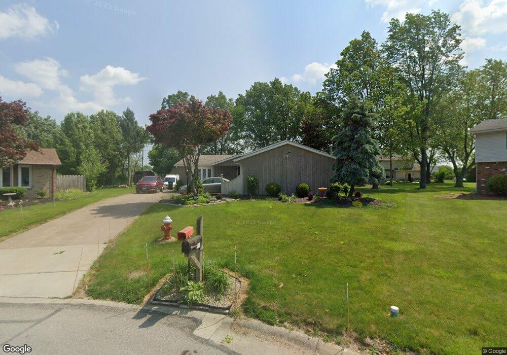
401 Quail Ct Amherst, OH 44001
Estimated Value: $291,526 - $332,000
3
Beds
2
Baths
2,220
Sq Ft
$141/Sq Ft
Est. Value
About This Home
This home is located at 401 Quail Ct, Amherst, OH 44001 and is currently estimated at $313,382, approximately $141 per square foot. 401 Quail Ct is a home located in Lorain County with nearby schools including Powers Elementary School, Walter G. Nord Middle School, and Amherst Junior High School.
Ownership History
Date
Name
Owned For
Owner Type
Purchase Details
Closed on
Aug 4, 2015
Sold by
Paghi Rosemarie J
Bought by
Paghi Daniel W
Current Estimated Value
Purchase Details
Closed on
May 19, 1998
Sold by
Christner James L and Christner Lynne M
Bought by
Paghi Daniel W and Paghi Rosemarie J
Home Financials for this Owner
Home Financials are based on the most recent Mortgage that was taken out on this home.
Original Mortgage
$70,000
Outstanding Balance
$13,880
Interest Rate
7.27%
Estimated Equity
$299,502
Create a Home Valuation Report for This Property
The Home Valuation Report is an in-depth analysis detailing your home's value as well as a comparison with similar homes in the area
Home Values in the Area
Average Home Value in this Area
Purchase History
| Date | Buyer | Sale Price | Title Company |
|---|---|---|---|
| Paghi Daniel W | -- | None Available | |
| Paghi Daniel W | $135,000 | Midland Title |
Source: Public Records
Mortgage History
| Date | Status | Borrower | Loan Amount |
|---|---|---|---|
| Open | Paghi Daniel W | $70,000 |
Source: Public Records
Tax History
| Year | Tax Paid | Tax Assessment Tax Assessment Total Assessment is a certain percentage of the fair market value that is determined by local assessors to be the total taxable value of land and additions on the property. | Land | Improvement |
|---|---|---|---|---|
| 2024 | $3,095 | $86,447 | $20,405 | $66,042 |
| 2023 | $2,711 | $65,755 | $13,514 | $52,241 |
| 2022 | $2,618 | $65,755 | $13,514 | $52,241 |
| 2021 | $2,625 | $65,755 | $13,514 | $52,241 |
| 2020 | $2,515 | $57,230 | $11,760 | $45,470 |
| 2019 | $2,465 | $57,230 | $11,760 | $45,470 |
| 2018 | $2,477 | $57,230 | $11,760 | $45,470 |
| 2017 | $2,487 | $54,440 | $10,260 | $44,180 |
| 2016 | $2,508 | $54,440 | $10,260 | $44,180 |
| 2015 | $2,494 | $54,440 | $10,260 | $44,180 |
| 2014 | $2,310 | $50,880 | $9,590 | $41,290 |
| 2013 | $2,317 | $50,880 | $9,590 | $41,290 |
Source: Public Records
Map
Nearby Homes
- 423 Quarry Creek Dr
- 1011 N Main St
- 110 Habant Dr
- 1301 N Main St
- 120 Springvale Dr
- 320 Pebble Creek Ct
- 109 Beaver Creek Trail
- 110 Beaver Creek Trail
- 4872 Leavitt Rd
- 707 Lincoln St
- 3982 Courtyard Dr
- 703 N Main St
- 4497 Bellow Dr
- 0 Leavitt Rd Unit 5169364
- 4513 Vineyard Dr
- 5946 N Mayflower Dr
- 3794 Freedom Place
- 3788 Freedom Place
- 3784 Freedom Place
- 3774 Freedom Place Unit A
- 369 Quail Ct
- 400 Quail Ct
- 1140 Meadowview Ln
- 1130 Meadowview Ln
- 1150 Meadowview Ln
- 374 Killdeer Dr
- 351 Quail Ct
- 372 Quail Ct
- 1120 Meadowview Ln
- 1160 Meadowview Ln
- 402 Killdeer Dr
- 354 Quail Ct
- 356 Killdeer Dr
- 1141 Meadowbrook Dr
- 1110 Meadowview Ln
- 1170 Meadowview Ln
- 338 Killdeer Dr
- 1121 Meadowbrook Dr
- 338 Killdeer Ct
- 473 Cooper Foster Park Rd
Your Personal Tour Guide
Ask me questions while you tour the home.