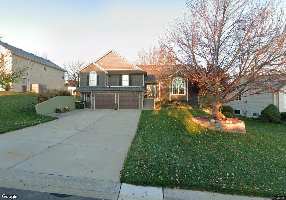
403 Maple Ct Lansing, KS 66043
Estimated Value: $314,642 - $362,000
4
Beds
3
Baths
1,652
Sq Ft
$207/Sq Ft
Est. Value
About This Home
This home is located at 403 Maple Ct, Lansing, KS 66043 and is currently estimated at $341,411, approximately $206 per square foot. 403 Maple Ct is a home located in Leavenworth County with nearby schools including Lansing Elementary School, Lansing Middle 6-8, and Lansing High 9-12.
Ownership History
Date
Name
Owned For
Owner Type
Purchase Details
Closed on
Jan 9, 2020
Sold by
Schwind Michael W and Schwind Patricia A
Bought by
Schwind Trust and Schwind
Current Estimated Value
Purchase Details
Closed on
Jun 1, 1998
Bought by
Schwind Michael W and Schwind Patricia A
Home Financials for this Owner
Home Financials are based on the most recent Mortgage that was taken out on this home.
Original Mortgage
$74,420
Interest Rate
7.07%
Mortgage Type
New Conventional
Create a Home Valuation Report for This Property
The Home Valuation Report is an in-depth analysis detailing your home's value as well as a comparison with similar homes in the area
Home Values in the Area
Average Home Value in this Area
Purchase History
| Date | Buyer | Sale Price | Title Company |
|---|---|---|---|
| Schwind Trust | -- | None Listed On Document | |
| Schwind Michael W | $153,250 | -- |
Source: Public Records
Mortgage History
| Date | Status | Borrower | Loan Amount |
|---|---|---|---|
| Previous Owner | Schwind Michael W | $74,420 | |
| Closed | Schwind Michael W | $50,000 |
Source: Public Records
Tax History
| Year | Tax Paid | Tax Assessment Tax Assessment Total Assessment is a certain percentage of the fair market value that is determined by local assessors to be the total taxable value of land and additions on the property. | Land | Improvement |
|---|---|---|---|---|
| 2025 | $4,760 | $36,860 | $5,801 | $31,059 |
| 2024 | $4,421 | $35,442 | $5,801 | $29,641 |
| 2023 | $4,421 | $34,080 | $5,801 | $28,279 |
| 2022 | $4,251 | $30,981 | $4,181 | $26,800 |
| 2021 | $3,900 | $27,117 | $4,181 | $22,936 |
| 2020 | $3,704 | $25,357 | $4,181 | $21,176 |
| 2019 | $3,621 | $24,759 | $4,181 | $20,578 |
| 2018 | $3,389 | $23,207 | $4,181 | $19,026 |
| 2017 | $3,277 | $22,394 | $4,181 | $18,213 |
| 2016 | $3,221 | $22,011 | $4,181 | $17,830 |
| 2015 | $3,336 | $22,850 | $4,181 | $18,669 |
| 2014 | $3,267 | $22,850 | $4,181 | $18,669 |
Source: Public Records
Map
Nearby Homes
- 530 Holiday Ct
- 00000 Brookwood St
- 950 Holiday Dr
- 20958 Ida St
- 1017 Pebble Beach Dr
- 1101 Pebble Beach Dr
- Lot 2 Eisenhower Rd
- 134 Debra St
- 124 S Main St
- 202 S Main St
- 728 Eisenhower Rd
- 1102 N Main St
- 4 Eisenhower Rd
- 26731 147th St
- 1015 Mount Calvary Rd
- 1100 N 4th St
- 1102 N 4th St
- 503 S 1st St
- 218 E Kay St
- 804 Glenview St
Your Personal Tour Guide
Ask me questions while you tour the home.