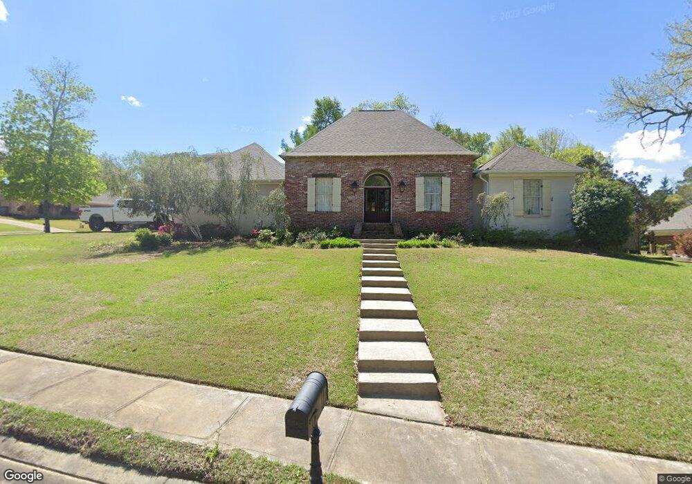
404 Cedar Hurst Ln Madison, MS 39110
Estimated Value: $378,045 - $426,000
4
Beds
3
Baths
2,707
Sq Ft
$150/Sq Ft
Est. Value
About This Home
This home is located at 404 Cedar Hurst Ln, Madison, MS 39110 and is currently estimated at $406,761, approximately $150 per square foot. 404 Cedar Hurst Ln is a home located in Madison County with nearby schools including Madison Avenue Upper Elementary School, Madison Avenue Elementary, and Madison Middle School.
Ownership History
Date
Name
Owned For
Owner Type
Purchase Details
Closed on
Oct 10, 2017
Sold by
Gandy Dale A
Bought by
Gandy Lydia K
Current Estimated Value
Purchase Details
Closed on
Oct 1, 2014
Sold by
Lockey Payton L and Lockey Amanda W
Bought by
Gandy Dale and Gandy Lydia
Home Financials for this Owner
Home Financials are based on the most recent Mortgage that was taken out on this home.
Original Mortgage
$250,000
Interest Rate
4.16%
Mortgage Type
Purchase Money Mortgage
Purchase Details
Closed on
Sep 12, 2006
Sold by
Maloney Gregory M and Maloney Laura G
Bought by
Lockey Payton L and Lockkey Amanda W
Create a Home Valuation Report for This Property
The Home Valuation Report is an in-depth analysis detailing your home's value as well as a comparison with similar homes in the area
Home Values in the Area
Average Home Value in this Area
Purchase History
| Date | Buyer | Sale Price | Title Company |
|---|---|---|---|
| Gandy Lydia K | -- | None Available | |
| Gandy Dale | -- | None Available | |
| Lockey Payton L | -- | None Available |
Source: Public Records
Mortgage History
| Date | Status | Borrower | Loan Amount |
|---|---|---|---|
| Previous Owner | Gandy Dale | $250,000 |
Source: Public Records
Tax History
| Year | Tax Paid | Tax Assessment Tax Assessment Total Assessment is a certain percentage of the fair market value that is determined by local assessors to be the total taxable value of land and additions on the property. | Land | Improvement |
|---|---|---|---|---|
| 2025 | $2,731 | $26,009 | $0 | $0 |
| 2024 | $2,731 | $26,009 | $0 | $0 |
| 2023 | $2,731 | $26,009 | $0 | $0 |
| 2022 | $2,731 | $26,009 | $0 | $0 |
| 2021 | $2,611 | $24,984 | $0 | $0 |
| 2020 | $4,367 | $37,476 | $0 | $0 |
| 2019 | $4,367 | $37,476 | $0 | $0 |
| 2018 | $2,911 | $24,984 | $0 | $0 |
| 2017 | $2,864 | $24,575 | $0 | $0 |
| 2016 | $2,564 | $24,575 | $0 | $0 |
| 2015 | -- | $24,575 | $0 | $0 |
| 2014 | $2,890 | $27,372 | $0 | $0 |
Source: Public Records
Map
Nearby Homes
- 112 Woodsong Way
- 161 Victoria Place
- 1205 Woodberry Dr
- 209 Pine Place
- 865 Wellington Way
- 105 Victoria Place
- 212 N Ridge Dr
- 1241 Woodberry Dr
- 290 Geneva Blvd
- 138 Oakmont Dr
- 169 Saint Ives Dr
- 1141 Highway 51
- 636 Live Oak Dr
- 717 Wildberry Pointe
- 235 Hawthorne Dr
- 106 Normandy Ct
- 325 Mockingbird Ln
- 202 Saint Pierre Cove
- 143 Azalea Cir
- 200 Hawthorne Dr
- 289 Oak Park Dr
- 125 Woodsong Way
- 259 Oak Park Dr
- 129 Woodsong Way
- 409 Cedar Hurst Ln
- 256 Oak Park Dr
- 405 Cedar Hurst Ln
- 252 Oak Park Dr
- 264 Oak Park Dr
- 133 Woodsong Way
- 260 Oak Park Dr
- 121 Woodsong Way
- 248 Oak Park Dr
- 128 Woodsong Way
- 124 Woodsong Way
- 608 Crestridge Ct
- 604 Crestridge Ct
- 225 Oak Park Dr
- 134 Woodsong Way
- 419 West Place
Your Personal Tour Guide
Ask me questions while you tour the home.