Estimated Value: $289,000 - $360,000
4
Beds
2
Baths
2,048
Sq Ft
$157/Sq Ft
Est. Value
About This Home
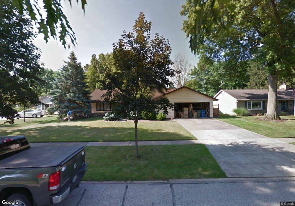
This home is located at 404 Cranston Dr, Berea, OH 44017 and is currently estimated at $322,037, approximately $157 per square foot. 404 Cranston Dr is a home located in Cuyahoga County with nearby schools including Grindstone Elementary School, Berea-Midpark Middle School, and Berea-Midpark High School.
Ownership History
Date
Name
Owned For
Owner Type
Purchase Details
Closed on
Jun 14, 2016
Sold by
Bastik Robert and Parker Jeffrey S
Bought by
Pietch Richard E and Pietch Sherry L
Current Estimated Value
Home Financials for this Owner
Home Financials are based on the most recent Mortgage that was taken out on this home.
Original Mortgage
$75,000
Outstanding Balance
$32,598
Interest Rate
2.86%
Mortgage Type
New Conventional
Estimated Equity
$289,439
Purchase Details
Closed on
Aug 15, 1979
Sold by
Stumpf Robert W and Stumpf Marlene L
Bought by
Marlene L Stumpf
Purchase Details
Closed on
Jan 1, 1975
Bought by
Stumpf Robert W and Stumpf Marlene L
Create a Home Valuation Report for This Property
The Home Valuation Report is an in-depth analysis detailing your home's value as well as a comparison with similar homes in the area
Home Values in the Area
Average Home Value in this Area
Purchase History
| Date | Buyer | Sale Price | Title Company |
|---|---|---|---|
| Pietch Richard E | $170,000 | Northern Title Agency Inc | |
| Marlene L Stumpf | -- | -- | |
| Stumpf Robert W | -- | -- |
Source: Public Records
Mortgage History
| Date | Status | Borrower | Loan Amount |
|---|---|---|---|
| Open | Pietch Richard E | $75,000 |
Source: Public Records
Tax History
| Year | Tax Paid | Tax Assessment Tax Assessment Total Assessment is a certain percentage of the fair market value that is determined by local assessors to be the total taxable value of land and additions on the property. | Land | Improvement |
|---|---|---|---|---|
| 2024 | $5,014 | $96,355 | $16,905 | $79,450 |
| 2023 | $4,205 | $69,860 | $14,420 | $55,440 |
| 2022 | $4,207 | $69,860 | $14,420 | $55,440 |
| 2021 | $4,169 | $69,860 | $14,420 | $55,440 |
| 2020 | $3,882 | $59,190 | $12,220 | $46,970 |
| 2019 | $3,779 | $169,100 | $34,900 | $134,200 |
| 2018 | $3,728 | $58,870 | $12,220 | $46,660 |
| 2017 | $3,290 | $49,710 | $11,030 | $38,680 |
| 2016 | $3,266 | $49,710 | $11,030 | $38,680 |
| 2015 | $3,070 | $49,710 | $11,030 | $38,680 |
| 2014 | $3,284 | $52,330 | $11,620 | $40,710 |
Source: Public Records
Map
Nearby Homes
- 550 Race St
- 549 Wyleswood Dr
- 561 Brigton Dr
- 647 Tampico Ct Unit 7
- 23002 Chandlers Ln Unit 223
- 23002 Chandlers Ln Unit 221
- 388 Fairwood Cir
- 23155 Wainwright Terrace
- 23411 Grist Mill Ct Unit 2
- 23265 Wainwright Terrace
- 287 Edgewood Dr
- 300 West St
- 628 Lindbergh Blvd
- 23004 Chandlers Ln Unit 4-344
- 8873 Ashlyn Ct Unit 13A
- 8757 Roberts Ct Unit 25C
- 404 Crescent Dr
- 458 Sprague Rd
- 516 Fair St
- 216 Kraft St
- 404 Cranston Dr
- 386 Cranston Dr
- 392 Cranston Dr
- 396 Cranston Dr
- 416 Cranston Dr
- 398 Cranston Dr
- 450 Walleyford Dr
- 388 Cranston Dr
- 455 Walleyford Dr
- 430 Cranston Dr
- 401 Cranston Dr
- 360 Cranston Dr
- 403 Cranston Dr
- 395 Cranston Dr
- 395 Cranston Dr
- 409 Cranston Dr
- 411 Cranston Dr
- 456 Walleyford Dr
- 378 Cranston Dr
- 446 Cranston Dr
Your Personal Tour Guide
Ask me questions while you tour the home.