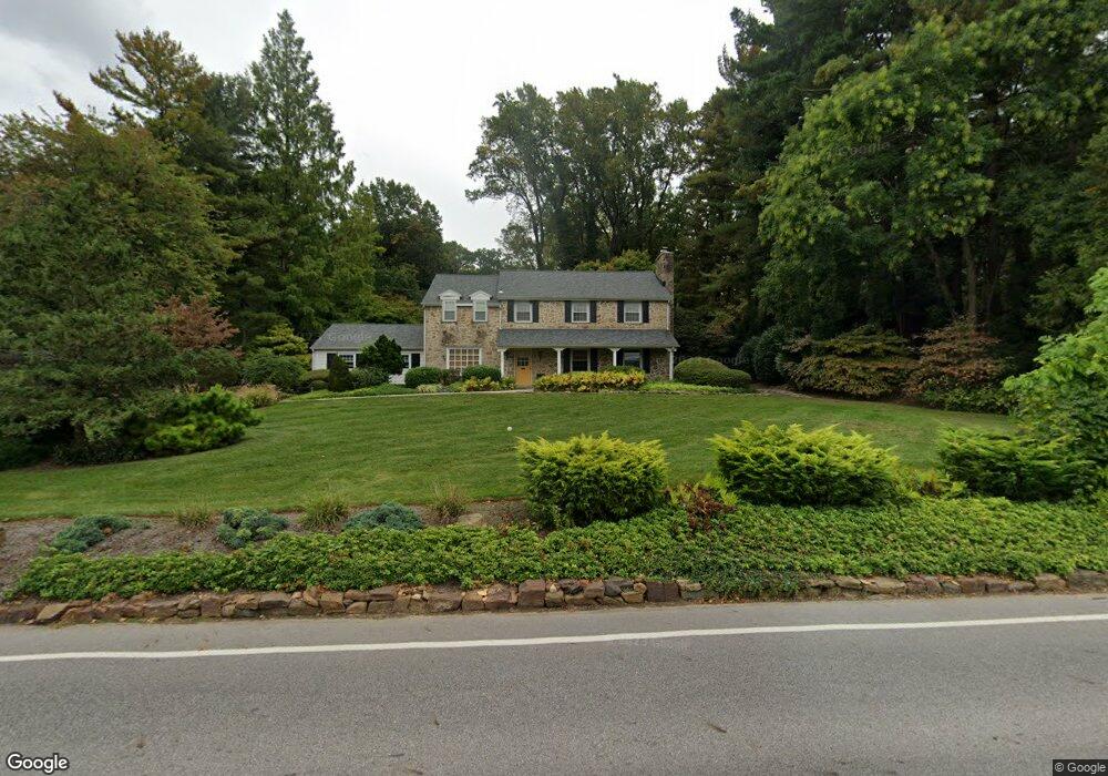
404 Station Ave Glenside, PA 19038
Estimated Value: $567,000 - $757,000
4
Beds
3
Baths
2,846
Sq Ft
$240/Sq Ft
Est. Value
About This Home
This home is located at 404 Station Ave, Glenside, PA 19038 and is currently estimated at $682,545, approximately $239 per square foot. 404 Station Ave is a home located in Montgomery County with nearby schools including Enfield Elementary School, Erdenheim Elementary School, and Springfield Township Middle School.
Ownership History
Date
Name
Owned For
Owner Type
Purchase Details
Closed on
Mar 5, 2008
Sold by
Hocynec Adelaide F and Flynn Adelaide M
Bought by
Campbell Denise and Campbell Joseph
Current Estimated Value
Home Financials for this Owner
Home Financials are based on the most recent Mortgage that was taken out on this home.
Original Mortgage
$300,000
Outstanding Balance
$186,996
Interest Rate
5.75%
Estimated Equity
$495,549
Create a Home Valuation Report for This Property
The Home Valuation Report is an in-depth analysis detailing your home's value as well as a comparison with similar homes in the area
Home Values in the Area
Average Home Value in this Area
Purchase History
| Date | Buyer | Sale Price | Title Company |
|---|---|---|---|
| Campbell Denise | $425,000 | None Available |
Source: Public Records
Mortgage History
| Date | Status | Borrower | Loan Amount |
|---|---|---|---|
| Open | Campbell Denise | $300,000 |
Source: Public Records
Tax History Compared to Growth
Tax History
| Year | Tax Paid | Tax Assessment Tax Assessment Total Assessment is a certain percentage of the fair market value that is determined by local assessors to be the total taxable value of land and additions on the property. | Land | Improvement |
|---|---|---|---|---|
| 2025 | $10,842 | $230,180 | $57,270 | $172,910 |
| 2024 | $10,842 | $230,180 | $57,270 | $172,910 |
| 2023 | $10,464 | $230,180 | $57,270 | $172,910 |
| 2022 | $10,165 | $230,180 | $57,270 | $172,910 |
| 2021 | $9,899 | $230,180 | $57,270 | $172,910 |
| 2020 | $9,668 | $230,180 | $57,270 | $172,910 |
| 2019 | $9,519 | $230,180 | $57,270 | $172,910 |
| 2018 | $9,519 | $230,180 | $57,270 | $172,910 |
| 2017 | $9,087 | $230,180 | $57,270 | $172,910 |
| 2016 | $8,997 | $230,180 | $57,270 | $172,910 |
| 2015 | $8,553 | $230,180 | $57,270 | $172,910 |
| 2014 | $8,553 | $230,180 | $57,270 | $172,910 |
Source: Public Records
Map
Nearby Homes
- 711 Custis Rd
- 56 Chelfield Rd
- 0 Logan Ave Unit PAMC2112680
- 220 Garth Rd
- 2006 Lodges Ln
- 120 Linden Ave
- 65 Limekiln Pike
- 140 Linden Ave
- 200 Redford Rd
- 516 Beaver Rd
- 162 Logan Ave
- 222 Ruscombe Ave
- 446 Twickenham Rd
- 504 Plymouth Rd
- 1943 Fawn Dr
- 122 Garden Rd
- 116 Twining Rd
- 245 Linden Ave
- 118 Twining Rd
- 1313 Bruce Rd
- 400 Station Ave
- 335 Woods Rd
- 401 Station Ave
- 319 Woods Rd
- 323 Woods Rd
- 802 S Fairway Rd
- 312 Station Ave
- 315 Woods Rd
- 801 S Fairway Rd
- 804 S Fairway Rd
- 336 Woods Rd
- 327 Woods Rd
- 313 Station Ave
- 311 Woods Rd
- 310 Station Ave
- 806 S Fairway Rd
- 805 S Fairway Rd
- 320 Woods Rd
- 309 Station Ave
- 316 Woods Rd Unit 15