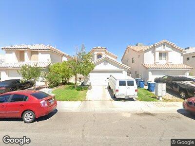
4056 Abrams Ave Las Vegas, NV 89110
East Las Vegas NeighborhoodEstimated Value: $341,000 - $352,000
3
Beds
3
Baths
1,323
Sq Ft
$263/Sq Ft
Est. Value
About This Home
This home is located at 4056 Abrams Ave, Las Vegas, NV 89110 and is currently estimated at $347,322, approximately $262 per square foot. 4056 Abrams Ave is a home located in Clark County with nearby schools including C C Ronnow Elementary School, Mario C. & Joanne Monaco Middle School, and Desert Pines High School.
Ownership History
Date
Name
Owned For
Owner Type
Purchase Details
Closed on
Jun 2, 2000
Sold by
Heller Hacienda Llc
Bought by
Pippens Samuel
Current Estimated Value
Home Financials for this Owner
Home Financials are based on the most recent Mortgage that was taken out on this home.
Original Mortgage
$117,025
Interest Rate
8.15%
Mortgage Type
FHA
Create a Home Valuation Report for This Property
The Home Valuation Report is an in-depth analysis detailing your home's value as well as a comparison with similar homes in the area
Home Values in the Area
Average Home Value in this Area
Purchase History
| Date | Buyer | Sale Price | Title Company |
|---|---|---|---|
| Pippens Samuel | $117,990 | Lawyers Title |
Source: Public Records
Mortgage History
| Date | Status | Borrower | Loan Amount |
|---|---|---|---|
| Open | Pippens Samuel | $220,000 | |
| Closed | Pippens Samuel | $187,000 | |
| Closed | Pippens Samuel | $117,025 |
Source: Public Records
Tax History Compared to Growth
Tax History
| Year | Tax Paid | Tax Assessment Tax Assessment Total Assessment is a certain percentage of the fair market value that is determined by local assessors to be the total taxable value of land and additions on the property. | Land | Improvement |
|---|---|---|---|---|
| 2025 | $1,181 | $72,915 | $22,750 | $50,165 |
| 2024 | $1,094 | $72,915 | $22,750 | $50,165 |
| 2023 | $1,094 | $72,360 | $24,850 | $47,510 |
| 2022 | $1,013 | $64,640 | $21,350 | $43,290 |
| 2021 | $938 | $60,137 | $18,900 | $41,237 |
| 2020 | $868 | $58,457 | $17,500 | $40,957 |
| 2019 | $814 | $55,069 | $14,700 | $40,369 |
| 2018 | $777 | $49,164 | $10,500 | $38,664 |
| 2017 | $1,580 | $48,199 | $9,100 | $39,099 |
| 2016 | $728 | $40,359 | $7,000 | $33,359 |
| 2015 | $726 | $28,840 | $5,600 | $23,240 |
| 2014 | $704 | $20,844 | $3,850 | $16,994 |
Source: Public Records
Map
Nearby Homes
- 1400 Jamielinn Ln Unit 104
- 1400 Jamielinn Ln Unit 102
- 1001 Declaration Dr
- 1501 Linnbaker Ln Unit 103
- 1509 Linnbaker Ln Unit 203
- 3965 Rebecca Raiter Ave Unit 201
- 1505 Frank Aved St Unit 101
- 3953 Rebecca Raiter Ave Unit 202
- 3953 Rebecca Raiter Ave Unit 101
- 1520 Henry Dr
- 1524 Henry Dr
- 1541 Linnbaker Ln Unit 202
- 1550 Jamielinn Ln Unit 102
- 1560 Jamielinn Ln Unit 101
- 1570 Jamielinn Ln Unit 104
- 4315 Lynnann Dr
- 1417 Virgil St
- 1618 Meno Peak St
- 1644 Square Fields St
- 1673 Square Fields St
- 4056 Abrams Ave
- 4052 Abrams Ave
- 4100 Abrams Ave Unit 3
- 4104 Abrams Ave
- 4048 Abrams Ave
- 4044 Abrams Ave Unit 3
- 4108 Abrams Ave
- 4112 Abrams Ave
- 4040 Abrams Ave
- 4057 Abrams Ave
- 4101 Abrams Ave
- 4053 Abrams Ave Unit 3
- 4049 Abrams Ave
- 4105 Abrams Ave
- 4116 Abrams Ave
- 4036 Abrams Ave
- 4045 Abrams Ave
- 4109 Abrams Ave
- 4041 Abrams Ave
- 4113 Abrams Ave