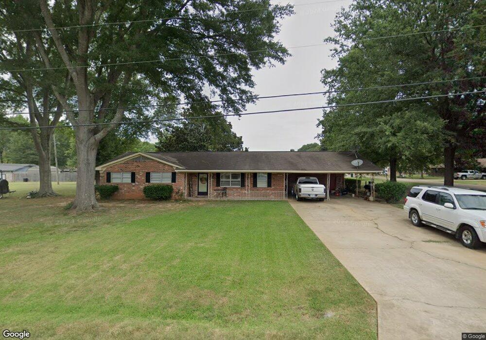
406 S Hampton Ave New Albany, MS 38652
Estimated Value: $200,702 - $234,000
--
Bed
2
Baths
1,622
Sq Ft
$136/Sq Ft
Est. Value
About This Home
This home is located at 406 S Hampton Ave, New Albany, MS 38652 and is currently estimated at $220,426, approximately $135 per square foot. 406 S Hampton Ave is a home located in Union County with nearby schools including New Albany Elementary School, New Albany/S.Tippah/Union County Alternative School, and New Albany Middle School.
Ownership History
Date
Name
Owned For
Owner Type
Purchase Details
Closed on
Feb 14, 2017
Sold by
Thompson Pamela J
Bought by
Simmons Myra and Living Word Faith Center
Current Estimated Value
Home Financials for this Owner
Home Financials are based on the most recent Mortgage that was taken out on this home.
Original Mortgage
$131,727
Interest Rate
4.09%
Mortgage Type
Purchase Money Mortgage
Purchase Details
Closed on
Jan 6, 2012
Sold by
Strait Rita Jo and Gement Mildred C
Bought by
Thompson Pamela J
Create a Home Valuation Report for This Property
The Home Valuation Report is an in-depth analysis detailing your home's value as well as a comparison with similar homes in the area
Home Values in the Area
Average Home Value in this Area
Purchase History
| Date | Buyer | Sale Price | Title Company |
|---|---|---|---|
| Simmons Myra | -- | -- | |
| Simmons Myra | -- | None Available | |
| Thompson Pamela J | -- | -- |
Source: Public Records
Mortgage History
| Date | Status | Borrower | Loan Amount |
|---|---|---|---|
| Previous Owner | Simmons Myra | $131,727 |
Source: Public Records
Tax History Compared to Growth
Tax History
| Year | Tax Paid | Tax Assessment Tax Assessment Total Assessment is a certain percentage of the fair market value that is determined by local assessors to be the total taxable value of land and additions on the property. | Land | Improvement |
|---|---|---|---|---|
| 2024 | -- | $0 | $0 | $0 |
| 2023 | -- | $0 | $0 | $0 |
| 2022 | $0 | $0 | $0 | $0 |
| 2021 | $876 | $0 | $0 | $0 |
| 2020 | $876 | $0 | $0 | $0 |
| 2019 | $876 | $0 | $0 | $0 |
| 2018 | $876 | $0 | $0 | $0 |
| 2017 | $876 | $8,637 | $0 | $0 |
| 2016 | $837 | $8,637 | $0 | $0 |
| 2015 | -- | $8,637 | $0 | $0 |
| 2014 | -- | $8,023 | $0 | $0 |
Source: Public Records
Map
Nearby Homes
- 403 Bristol Ave
- 0 Hwy 30 West - 2 Acres Unit 25-34
- Lot 909 W Longview Dr
- 0 Coulter Cove + - 52 Ac
- 1004 Lakewood Dr
- 714 W Shady Ln
- 621 Glendale Rd
- 0 Coulter Dr Denton Rd Unit 24-3689
- Lot 102 Greenhaven Dr
- Lot 92 Greenhaven Dr
- Lot 100 Greenhaven Dr
- Lot 84 Greenhaven Dr
- Lot 78 Greenhaven Dr
- Lot 80 Greenhaven Dr
- Lot 76 Greenhaven Dr
- Lot 75 Greenhaven Dr
- 816 W Bankhead St
- 0 Park Plaza Dr
- 102 Robbins Dr
- 0 Bratton Rd
- 507 Walnut St
- 507 Walnut St
- 407 S Hampton Ave
- 408 S Hampton Ave
- 409 S Hampton Ave
- 506 Spring Blvd
- 404 S Hampton Ave
- 506 Walnut St
- 411 S Hampton Ave
- 405 S Hampton Ave
- 407 Manchester Ave
- 407 Manchester Ave
- 403 Manchester Ave
- 505 Walnut St
- 500 Walnut St
- 403 S Hampton Ave
- 403 S Hampton Ave
- 404 Manchester
- 404 Manchester Ave
- 503 Cherry Blvd