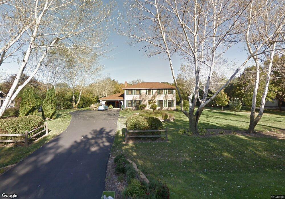
40W134 Sturbridge Way Elgin, IL 60124
Bowes NeighborhoodEstimated Value: $497,997 - $552,000
4
Beds
3
Baths
2,268
Sq Ft
$231/Sq Ft
Est. Value
About This Home
This home is located at 40W134 Sturbridge Way, Elgin, IL 60124 and is currently estimated at $522,999, approximately $230 per square foot. 40W134 Sturbridge Way is a home located in Kane County with nearby schools including Howard B. Thomas Grade School, Prairie Knolls Middle School, and Central Middle School.
Ownership History
Date
Name
Owned For
Owner Type
Purchase Details
Closed on
Feb 8, 1998
Sold by
Kaufman Tina and Baumgartner Tina
Bought by
Baumgartner Richard
Current Estimated Value
Home Financials for this Owner
Home Financials are based on the most recent Mortgage that was taken out on this home.
Original Mortgage
$157,000
Outstanding Balance
$27,497
Interest Rate
6.88%
Estimated Equity
$495,502
Purchase Details
Closed on
Feb 12, 1996
Sold by
Tcf Consumer Financial Services Inc
Bought by
Baumgartner Richard and Self Tina
Home Financials for this Owner
Home Financials are based on the most recent Mortgage that was taken out on this home.
Original Mortgage
$130,000
Interest Rate
6.65%
Purchase Details
Closed on
Apr 19, 1995
Sold by
Andrew Richard S and Andrew Kathleen J
Bought by
Tcf Consumer Financial Services Inc
Create a Home Valuation Report for This Property
The Home Valuation Report is an in-depth analysis detailing your home's value as well as a comparison with similar homes in the area
Home Values in the Area
Average Home Value in this Area
Purchase History
| Date | Buyer | Sale Price | Title Company |
|---|---|---|---|
| Baumgartner Richard | -- | First American Title Ins Co | |
| Baumgartner Richard | $167,500 | Century Title Company | |
| Tcf Consumer Financial Services Inc | $81,500 | -- |
Source: Public Records
Mortgage History
| Date | Status | Borrower | Loan Amount |
|---|---|---|---|
| Open | Baumgartner Richard | $157,000 | |
| Closed | Baumgartner Richard | $130,000 |
Source: Public Records
Tax History Compared to Growth
Tax History
| Year | Tax Paid | Tax Assessment Tax Assessment Total Assessment is a certain percentage of the fair market value that is determined by local assessors to be the total taxable value of land and additions on the property. | Land | Improvement |
|---|---|---|---|---|
| 2024 | $7,720 | $114,721 | $31,322 | $83,399 |
| 2023 | $7,353 | $103,773 | $28,333 | $75,440 |
| 2022 | $7,338 | $95,823 | $24,917 | $70,906 |
| 2021 | $6,963 | $89,312 | $24,072 | $65,240 |
| 2020 | $6,932 | $87,707 | $23,639 | $64,068 |
| 2019 | $6,929 | $86,573 | $23,333 | $63,240 |
| 2018 | $7,003 | $87,809 | $24,107 | $63,702 |
| 2017 | $6,658 | $84,748 | $23,496 | $61,252 |
| 2016 | $7,037 | $82,738 | $22,939 | $59,799 |
| 2015 | -- | $80,084 | $22,939 | $57,145 |
| 2014 | -- | $79,189 | $22,939 | $56,250 |
| 2013 | -- | $82,009 | $23,331 | $58,678 |
Source: Public Records
Map
Nearby Homes
- 40W156 Sturbridge Way
- 3646 Thornhill Dr
- 3660 Thornhill Dr
- 3689 Thornhill Dr
- 3870 Crooked Creek Dr
- 3591 Doral Dr
- Newcastle Plan at Ponds of Stony Creek - Phase II
- Windsor Plan at Ponds of Stony Creek - Phase II
- Bluestone Plan at Ponds of Stony Creek - Phase II
- 3616 Sahara Rd
- 3587 Sandstone Cir
- 3608 Sandstone Cir
- 3612 Sandstone Cir
- Auburn Plan at Ponds of Stony Creek - Phase II
- Manchester Plan at Ponds of Stony Creek - Phase II
- Normandy Plan at Ponds of Stony Creek - Phase II
- Ridgefield Plan at Ponds of Stony Creek - Phase II
- Oxford Plan at Ponds of Stony Creek - Phase II
- 4378 John Milton Rd
- 1210 Falcon Ridge Dr
- 40W116 Sturbridge Way
- 40W180 Sturbridge Way
- 40W119 Sturbridge Way
- 40W098 Sturbridge Way
- 40W222 Sturbridge Way
- 40W175 Sturbridge Way
- 8N875 Corron Rd
- 40W076 Sturbridge Way
- 40W155 Sturbridge Way
- 8N783 Brimfield Dr
- 40W050 Sturbridge Way
- 40W041 Sturbridge Way
- 8n999 Corron Rd
- 40W221 Sturbridge Way
- 40W282 Sturbridge Way
- 8N768 Brimfield Dr
- 40W016 Sturbridge Way
- 3666 Open Pkwy
- 3668 Open Pkwy
- 3670 Open Pkwy