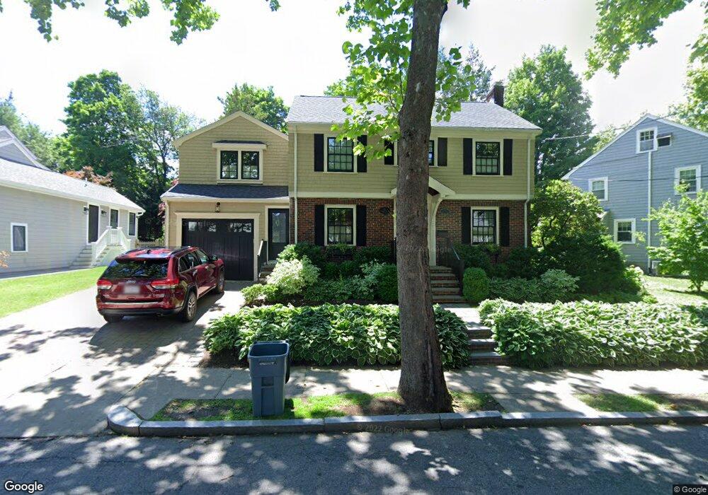
41 Carlson Cir West Roxbury, MA 02132
West Roxbury NeighborhoodEstimated Value: $946,000 - $1,507,271
3
Beds
2
Baths
1,435
Sq Ft
$884/Sq Ft
Est. Value
About This Home
This home is located at 41 Carlson Cir, West Roxbury, MA 02132 and is currently estimated at $1,268,318, approximately $883 per square foot. 41 Carlson Cir is a home located in Suffolk County with nearby schools including Holy Name Parish School, St Theresa School, and The Roxbury Latin School.
Ownership History
Date
Name
Owned For
Owner Type
Purchase Details
Closed on
Sep 17, 2020
Sold by
Diberardino Louis A and Diberardino Pamela M
Bought by
Pmd Ret
Current Estimated Value
Purchase Details
Closed on
Mar 19, 2012
Sold by
Diberardino Pamela M
Bought by
L & P Ret
Purchase Details
Closed on
Dec 14, 2007
Sold by
Klinger-Powell Amalia S and Powell Andrew J
Bought by
Prior Pamela M
Home Financials for this Owner
Home Financials are based on the most recent Mortgage that was taken out on this home.
Original Mortgage
$364,000
Interest Rate
6.3%
Mortgage Type
Purchase Money Mortgage
Purchase Details
Closed on
Jun 1, 1994
Sold by
Lane James and Lane Mary
Bought by
Powell Andrew J and Klinger Powell Amalia
Home Financials for this Owner
Home Financials are based on the most recent Mortgage that was taken out on this home.
Original Mortgage
$172,000
Interest Rate
8.49%
Mortgage Type
Purchase Money Mortgage
Purchase Details
Closed on
Jun 4, 1987
Sold by
Denis F Simon
Bought by
James Lane
Home Financials for this Owner
Home Financials are based on the most recent Mortgage that was taken out on this home.
Original Mortgage
$128,000
Interest Rate
10.38%
Mortgage Type
Purchase Money Mortgage
Create a Home Valuation Report for This Property
The Home Valuation Report is an in-depth analysis detailing your home's value as well as a comparison with similar homes in the area
Home Values in the Area
Average Home Value in this Area
Purchase History
| Date | Buyer | Sale Price | Title Company |
|---|---|---|---|
| Pmd Ret | -- | None Available | |
| L & P Ret | -- | -- | |
| Prior Pamela M | $455,000 | -- | |
| Powell Andrew J | $215,000 | -- | |
| James Lane | $228,000 | -- |
Source: Public Records
Mortgage History
| Date | Status | Borrower | Loan Amount |
|---|---|---|---|
| Previous Owner | James Lane | $380,000 | |
| Previous Owner | Prior Pamela M | $364,000 | |
| Previous Owner | James Lane | $172,000 | |
| Previous Owner | James Lane | $128,000 |
Source: Public Records
Tax History Compared to Growth
Tax History
| Year | Tax Paid | Tax Assessment Tax Assessment Total Assessment is a certain percentage of the fair market value that is determined by local assessors to be the total taxable value of land and additions on the property. | Land | Improvement |
|---|---|---|---|---|
| 2025 | $14,666 | $1,266,500 | $294,100 | $972,400 |
| 2024 | $14,859 | $1,363,200 | $314,500 | $1,048,700 |
| 2023 | $13,807 | $1,285,600 | $296,600 | $989,000 |
| 2022 | $12,717 | $1,168,800 | $269,700 | $899,100 |
| 2021 | $11,816 | $1,107,400 | $259,300 | $848,100 |
| 2020 | $10,480 | $992,400 | $234,200 | $758,200 |
| 2019 | $9,761 | $926,100 | $207,100 | $719,000 |
| 2018 | $9,335 | $890,700 | $207,100 | $683,600 |
| 2017 | $9,336 | $881,600 | $207,100 | $674,500 |
| 2016 | $9,064 | $824,000 | $207,100 | $616,900 |
| 2015 | $9,681 | $799,400 | $219,000 | $580,400 |
| 2014 | $7,590 | $603,360 | $175,200 | $428,160 |
Source: Public Records
Map
Nearby Homes
- 36 Courtney Rd
- 10 Burwell Rd
- 100 Russett Rd
- 102 Greaton Rd
- 72 Theodore Parker Rd
- 24 Burrwood Rd
- 170 Payson Rd
- 14 Ravenna Rd
- 76 Redlands Rd
- 1690 Centre St Unit 2
- 1789 Centre St Unit 202
- 1789 Centre St Unit 301
- 1487 Centre St Unit 1
- 168 Maple St
- 43 Ainsworth St Unit 2
- 208 South St
- 416 Belgrade Ave Unit 25
- 83 Payson Rd
- 37 Pomfret St
- 257 Belgrade Ave