41 Foss Flats Rd North Sandwich, NH 03259
Estimated payment $843/month
Highlights
- Water Access
- Stream or River on Lot
- The river is a source of water for the property
- River Front
- Wooded Lot
- High Speed Internet
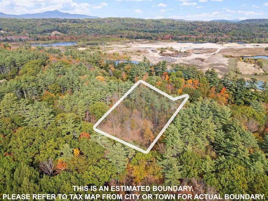
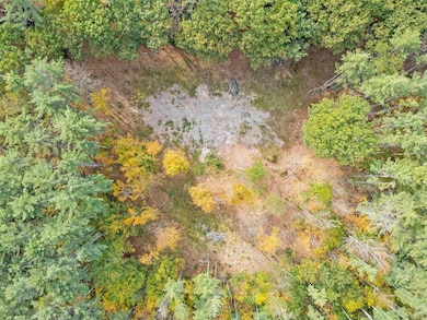
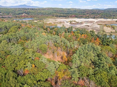
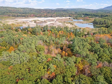
About This Lot
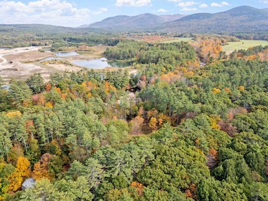
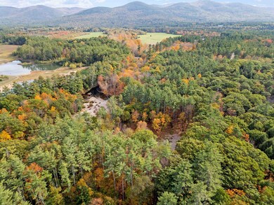
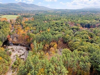
Discover the perfect blend of tranquility and convenience with this 1.3-acre lot located on Foss Flats Road in Sandwich, NH. This beautiful parcel offers frontage on the Cold River, creating a peaceful natural setting ideal for your dream home. The land features a mix of wooded privacy and a level, cleared portion—ready for your future build—while still maintaining the charm of New Hampshire’s natural landscape. Enjoy direct access to the river for quiet mornings by the water or afternoons spent exploring your own piece of nature. The lot’s level topography makes construction and site planning straightforward, while the wooded surroundings provide a sense of seclusion and harmony with the outdoors. Located just minutes from the historic village of Sandwich, you’ll find easy access to local hiking trails, Squam Lake, and the scenic Sandwich Fairgrounds. Lake Winnipesaukee is only a short drive away, offering endless opportunities for boating, swimming, and recreation. For commuters or weekend getaways, Concord is just over an hour south, and Boston is approximately two hours away—making this the perfect escape that still keeps you connected.
Property Details
Property Type
- Land
Est. Annual Taxes
- $602
Lot Details
- 1.3 Acre Lot
- River Front
- Level Lot
- Wooded Lot
- Property is zoned RURAL/RESID-VAC
Property Views
- Water Views
Outdoor Features
- Water Access
- Nearby Water Access
- Electricity Available at Street
- Stream or River on Lot
Schools
- Sandwich Central Elementary School
- Interlakes Middle School
- Interlakes High School
Utilities
- The river is a source of water for the property
- Well Required
- Septic Needed
- High Speed Internet
Listing and Financial Details
- Tax Block 8
- Assessor Parcel Number 212
Map
Home Values in the Area
Average Home Value in this Area
Tax History
| Year | Tax Paid | Tax Assessment Tax Assessment Total Assessment is a certain percentage of the fair market value that is determined by local assessors to be the total taxable value of land and additions on the property. | Land | Improvement |
|---|---|---|---|---|
| 2024 | $604 | $66,700 | $66,700 | $0 |
| 2023 | $1,747 | $113,300 | $54,000 | $59,300 |
| 2022 | $1,633 | $113,300 | $54,000 | $59,300 |
| 2021 | $1,639 | $113,300 | $54,000 | $59,300 |
| 2020 | $1,639 | $113,300 | $54,000 | $59,300 |
| 2019 | $1,612 | $113,300 | $54,000 | $59,300 |
| 2018 | $1,666 | $114,100 | $49,000 | $65,100 |
| 2017 | $1,645 | $114,100 | $49,000 | $65,100 |
| 2016 | $1,650 | $114,100 | $49,000 | $65,100 |
| 2015 | $1,594 | $114,100 | $49,000 | $65,100 |
| 2014 | $1,539 | $114,100 | $49,000 | $65,100 |
| 2013 | $1,613 | $144,000 | $59,400 | $84,600 |
Property History
| Date | Event | Price | List to Sale | Price per Sq Ft |
|---|---|---|---|---|
| 11/05/2025 11/05/25 | Price Changed | $150,000 | -11.8% | -- |
| 10/09/2025 10/09/25 | For Sale | $170,000 | -- | -- |
Purchase History
| Date | Type | Sale Price | Title Company |
|---|---|---|---|
| Warranty Deed | $160,000 | None Available | |
| Warranty Deed | $160,000 | None Available | |
| Warranty Deed | $65,000 | None Available | |
| Warranty Deed | $65,000 | None Available | |
| Warranty Deed | $65,000 | None Available |
Source: PrimeMLS
MLS Number: 5065011
APN: SDWI-000003R-000000-000045
Disclaimer: Certain information contained herein is derived from information provided by parties other than Homes.com. All information provided is deemed reliable, but is not guaranteed to be accurate and should be independently verified.
![]() Copyright 2025 PrimeMLS, Inc. All rights reserved. This information is deemed reliable, but not guaranteed. The data relating to real estate displayed on this display comes in part from the IDX Program of PrimeMLS. The information being provided is for consumers’ personal, non-commercial use and may not be used for any purpose other than to identify prospective properties consumers may be interested in purchasing.
Copyright 2025 PrimeMLS, Inc. All rights reserved. This information is deemed reliable, but not guaranteed. The data relating to real estate displayed on this display comes in part from the IDX Program of PrimeMLS. The information being provided is for consumers’ personal, non-commercial use and may not be used for any purpose other than to identify prospective properties consumers may be interested in purchasing.
- 385 Beede Flats Rd
- 659 N Sandwich Rd
- 00 Middle Rd Unit 23
- 224 Lot 20 Elijah Beede Rd
- 898 & 900 Bunker Hill Rd
- 900 Bunker Hill Rd
- 410-46 Hannah Rd
- 00 Partridge Hill Rd Unit 17
- 898 Bunker Hill Rd
- 347 Chase Rd
- 1252 Bearcamp Hwy
- 13 Mill Rd
- 829 Bearcamp Hwy
- 62 Whittier Hwy
- Map 418 Lot 2 Whittier Hwy
- 781 Mount Israel Rd
- 284 Wentworth Hill Rd
- 55 Hollow Hill Rd
- 45 Skinner St
- 27 Butternut Ln
- 959 Whittier Hwy Unit Winnipesaukee Commons Unit #4
- 168 Coolidge Farm Rd
- 105 Red Hill Rd
- 182 W Shore Dr
- 6 Bear Brook Ln Unit J-3
- 100 Singing Eagle Rd
- 6 Windsor Hill Way Unit Ellsworth
- 0 Windsor Hill Way
- 92 Singing Eagle Rd
- 15 Homestead Ln
- 242 High Haith Rd
- 23 Black Bear Rd Unit 202
- 21 Tripyramid Way Unit 23
- 10 Avalanche Way Unit 12
- 14 Maplewood Rd Unit 1
- 495 Center Harbor Neck Rd
- 7 Paugus Rd
- 68 Chickenboro Rd
- 11 Laurel Glen Ln
- 222 College Rd
