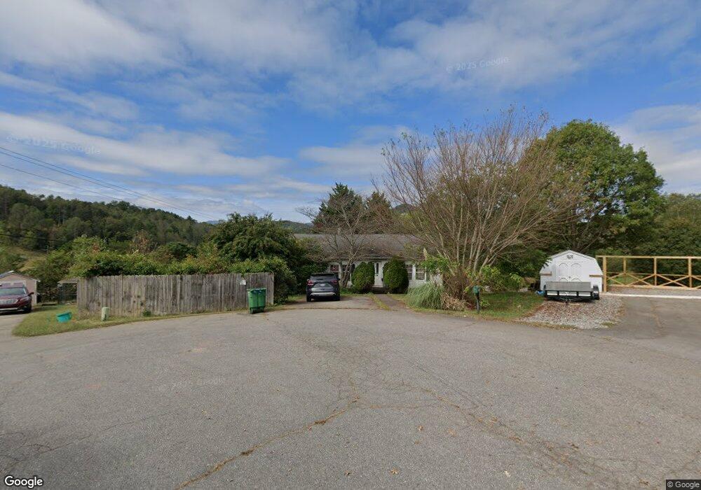
41 Haden Dr Leicester, NC 28748
Estimated Value: $293,000 - $450,228
3
Beds
2
Baths
1,568
Sq Ft
$222/Sq Ft
Est. Value
About This Home
This home is located at 41 Haden Dr, Leicester, NC 28748 and is currently estimated at $348,307, approximately $222 per square foot. 41 Haden Dr is a home located in Buncombe County with nearby schools including Leicester Elementary School, Clyde A. Erwin High School, and Clyde A. Erwin Middle School.
Ownership History
Date
Name
Owned For
Owner Type
Purchase Details
Closed on
Aug 9, 2019
Sold by
Caruso Caruso Dennis Dennis
Bought by
Caruso Tina
Current Estimated Value
Purchase Details
Closed on
Dec 20, 2002
Sold by
Caruso Rosalie and Caruso Anthony
Bought by
Caruso Rosalie and Anthony & Rosalie Caruso Family Trust
Purchase Details
Closed on
Oct 24, 2001
Sold by
Ball Patricia S
Bought by
Caruso Rosalie
Home Financials for this Owner
Home Financials are based on the most recent Mortgage that was taken out on this home.
Original Mortgage
$46,000
Outstanding Balance
$17,809
Interest Rate
6.74%
Estimated Equity
$330,498
Purchase Details
Closed on
Jul 9, 2000
Sold by
Conard Johnny A
Bought by
Ball Patricia S
Home Financials for this Owner
Home Financials are based on the most recent Mortgage that was taken out on this home.
Original Mortgage
$117,600
Interest Rate
8.23%
Mortgage Type
Credit Line Revolving
Create a Home Valuation Report for This Property
The Home Valuation Report is an in-depth analysis detailing your home's value as well as a comparison with similar homes in the area
Home Values in the Area
Average Home Value in this Area
Purchase History
| Date | Buyer | Sale Price | Title Company |
|---|---|---|---|
| Caruso Tina | -- | None Available | |
| Caruso Rosalie | -- | -- | |
| Caruso Rosalie | $126,000 | -- | |
| Ball Patricia S | $20,000 | -- |
Source: Public Records
Mortgage History
| Date | Status | Borrower | Loan Amount |
|---|---|---|---|
| Open | Caruso Rosalie | $46,000 | |
| Previous Owner | Ball Patricia S | $117,600 |
Source: Public Records
Tax History Compared to Growth
Tax History
| Year | Tax Paid | Tax Assessment Tax Assessment Total Assessment is a certain percentage of the fair market value that is determined by local assessors to be the total taxable value of land and additions on the property. | Land | Improvement |
|---|---|---|---|---|
| 2025 | $1,301 | $197,800 | $34,900 | $162,900 |
| 2024 | $1,301 | $197,800 | $34,900 | $162,900 |
| 2023 | $1,301 | $197,800 | $34,900 | $162,900 |
| 2022 | $1,143 | $197,800 | $34,900 | $162,900 |
| 2021 | $1,243 | $197,800 | $0 | $0 |
| 2020 | $1,162 | $173,700 | $0 | $0 |
| 2019 | $1,162 | $173,700 | $0 | $0 |
| 2018 | $1,162 | $173,700 | $0 | $0 |
| 2017 | $1,179 | $124,100 | $0 | $0 |
| 2016 | $923 | $124,100 | $0 | $0 |
| 2015 | $923 | $124,100 | $0 | $0 |
| 2014 | $886 | $124,100 | $0 | $0 |
Source: Public Records
Map
Nearby Homes
- 99 Colton Dr
- 30 Shire Way Ln
- 51 Farmstead Rd
- 211 Wimbledon Ct
- 703 Crestview Dr
- 28 Highcrest Dr
- 427 Shadowwood Dr
- TBD Don Felmet Rd
- 119 Big Sky Dr
- 31 Timber Hill Dr Unit LOT 19
- 118 Timber Ridge Cir Unit LOT 15
- 124 Sleepy Forest Dr
- 99 Timber Ridge Cir
- 223 Reilly Dr
- 3 the Shepherd Ridge
- 167 Selby Dr
- 24 Bob Wright Hill Rd
- 70 Rose Creek Rd
- 78 Rose Creek Rd
- 35 Dreambird Dr