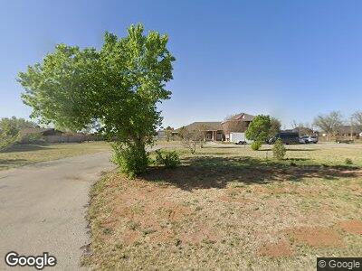
410 Who Who Dr Carlsbad, NM 88220
Estimated Value: $582,000 - $1,317,000
--
Bed
--
Bath
8,895
Sq Ft
$99/Sq Ft
Est. Value
About This Home
This home is located at 410 Who Who Dr, Carlsbad, NM 88220 and is currently estimated at $876,590, approximately $98 per square foot. 410 Who Who Dr is a home with nearby schools including Ocotillo Elementary School, PR Leyva CIS, and Carlsbad High School.
Ownership History
Date
Name
Owned For
Owner Type
Purchase Details
Closed on
Nov 3, 2011
Sold by
Hyden Todd S and Hyden Robyn S
Bought by
Folsom Lyle R and Folsom Miyung M
Current Estimated Value
Home Financials for this Owner
Home Financials are based on the most recent Mortgage that was taken out on this home.
Original Mortgage
$416,000
Interest Rate
3.99%
Mortgage Type
New Conventional
Create a Home Valuation Report for This Property
The Home Valuation Report is an in-depth analysis detailing your home's value as well as a comparison with similar homes in the area
Home Values in the Area
Average Home Value in this Area
Purchase History
| Date | Buyer | Sale Price | Title Company |
|---|---|---|---|
| Folsom Lyle R | -- | Guaranty Title Co |
Source: Public Records
Mortgage History
| Date | Status | Borrower | Loan Amount |
|---|---|---|---|
| Open | Folsom Lyle R | $592,000 | |
| Closed | Folsom Lyle R | $416,000 | |
| Previous Owner | Hyden Todd S | $20,000 | |
| Previous Owner | Hyden Todd S | $415,000 |
Source: Public Records
Tax History Compared to Growth
Tax History
| Year | Tax Paid | Tax Assessment Tax Assessment Total Assessment is a certain percentage of the fair market value that is determined by local assessors to be the total taxable value of land and additions on the property. | Land | Improvement |
|---|---|---|---|---|
| 2024 | $4,175 | $207,159 | $23,386 | $183,773 |
| 2023 | $4,175 | $207,159 | $23,386 | $183,773 |
| 2022 | $4,147 | $207,159 | $23,386 | $183,773 |
| 2021 | $4,126 | $207,159 | $23,386 | $183,773 |
| 2020 | $4,208 | $207,159 | $23,386 | $183,773 |
| 2019 | $4,246 | $207,159 | $23,386 | $183,773 |
| 2018 | $4,212 | $207,159 | $23,386 | $183,773 |
| 2017 | $4,352 | $215,417 | $24,088 | $191,329 |
| 2015 | $4,392 | $0 | $0 | $0 |
| 2014 | $3,608 | $0 | $0 | $0 |
Source: Public Records
Map
Nearby Homes
- 1801 N Guadalupe St
- 706 W Cherry Ln
- 115 S La Huerta Cir
- 1713 Loretta Ln
- 1509 Monroe St
- 1403 & 1405 N Guadalupe St
- 1421 N Country Club Cir
- 1516 Farrell Dr
- 1712 Live Oak Place
- 1503 Samoa Ct
- 1710 Live Oak Place
- 1510 Grant St
- 2325 Collins Ave
- 1504 Bryan Cir
- 2018-5 Mission Ave
- 1308 Gamma Ave
- 1403 S Country Club Cir
- 2506 N Crown Cir
- 1422 S Country Club Cir
- 1515 Desert Willow Dr
- 410 Who Who Dr
- 318 Who Who Dr
- 318 Who Who Dr
- 412 Who Who Dr
- 401 Who Who Dr
- 312 Who Who Dr
- 415 Who Who Dr
- 418 Who Who Dr
- 317 Who Who Dr
- 419 Who Who Dr
- 502 Who Who Dr
- 502 Who Who Dr
- 1912 Sandy Ln
- 416 Corrine Place
- 1910 Sandy Ln
- 412 Corrine Place
- 303 Who Who Dr
- 420 Corrine Place
- 302 Who Dr
- 507 Who Who Dr
