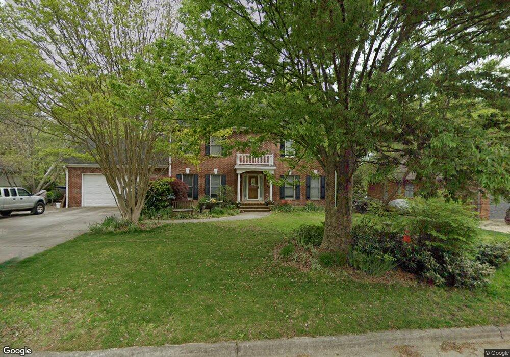
4110 Jeffrey Lane Point High Point, NC 27265
Deep River NeighborhoodEstimated Value: $453,000 - $566,000
4
Beds
4
Baths
2,620
Sq Ft
$188/Sq Ft
Est. Value
About This Home
This home is located at 4110 Jeffrey Lane Point, High Point, NC 27265 and is currently estimated at $492,240, approximately $187 per square foot. 4110 Jeffrey Lane Point is a home located in Guilford County with nearby schools including Southwest Elementary School, Welborn Academy of Science & Technology, and T.W. Andrews High School.
Ownership History
Date
Name
Owned For
Owner Type
Purchase Details
Closed on
Aug 9, 2007
Sold by
Scarpato Eugene E and Scarpato Michaela C
Bought by
Mcdonald Timothy Jay and Mcdonald Janis B
Current Estimated Value
Home Financials for this Owner
Home Financials are based on the most recent Mortgage that was taken out on this home.
Original Mortgage
$242,400
Outstanding Balance
$153,240
Interest Rate
6.63%
Mortgage Type
Purchase Money Mortgage
Estimated Equity
$339,000
Create a Home Valuation Report for This Property
The Home Valuation Report is an in-depth analysis detailing your home's value as well as a comparison with similar homes in the area
Home Values in the Area
Average Home Value in this Area
Purchase History
| Date | Buyer | Sale Price | Title Company |
|---|---|---|---|
| Mcdonald Timothy Jay | $306,000 | None Available |
Source: Public Records
Mortgage History
| Date | Status | Borrower | Loan Amount |
|---|---|---|---|
| Open | Mcdonald Timothy Jay | $242,400 |
Source: Public Records
Tax History Compared to Growth
Tax History
| Year | Tax Paid | Tax Assessment Tax Assessment Total Assessment is a certain percentage of the fair market value that is determined by local assessors to be the total taxable value of land and additions on the property. | Land | Improvement |
|---|---|---|---|---|
| 2025 | $4,696 | $340,800 | $60,300 | $280,500 |
| 2024 | $4,696 | $340,800 | $60,300 | $280,500 |
| 2023 | $4,696 | $340,800 | $60,300 | $280,500 |
| 2022 | $4,594 | $340,800 | $60,300 | $280,500 |
| 2021 | $4,196 | $304,500 | $56,700 | $247,800 |
| 2020 | $4,196 | $304,500 | $56,700 | $247,800 |
| 2019 | $4,196 | $304,500 | $0 | $0 |
| 2018 | $4,175 | $304,500 | $0 | $0 |
| 2017 | $4,175 | $304,500 | $0 | $0 |
| 2016 | $4,087 | $291,400 | $0 | $0 |
| 2015 | $4,109 | $291,400 | $0 | $0 |
| 2014 | $4,179 | $291,400 | $0 | $0 |
Source: Public Records
Map
Nearby Homes
- 4103 Quarterstaff Ct
- 4004 Baywater Point
- 3924 Braddock Rd
- 3007 Maple Branch Dr
- 3905 Wynne Brook Ct
- 3753 Carvette Ct
- 1515 Skeet Club Rd
- 4407 Oak Hollow Dr
- 4218 Pelican St
- Richmond Plan at Williard Place
- 3296 Alyssa Way
- Cameron Plan at Williard Place
- Southport Plan at Williard Place
- Columbia Plan at Williard Place
- Bailey Plan at Williard Place
- 3171 Riley Ford Trail Unit Lot 38
- 3301 Alyssa Way
- 3273 Alyssa Way
- 4307 Oak Hollow Dr
- 2170 Glen Cove Way
- 4112 Jeffrey Lane Point
- 4108 Jeffrey Lane Point
- 4106 Jeffrey Lane Point
- 4114 Jeffrey Lane Point
- 4111 Jeffrey Lane Point
- 4109 Jeffrey Lane Point
- 4107 Jeffrey Lane Point
- 4105 Jeffrey Lane Point
- 4116 Jeffrey Lane Point
- 1410 Christopher Ct
- 4104 Jeffrey Lane Point
- 1408 Christopher Ct
- 4118 Jeffrey Lane Point
- 4102 Jeffrey Lane Point
- 1406 Christopher Ct
- 4119 Jeffrey Lane Point
- 1411 Christopher Ct
- 4120 Jeffrey Lane Point
- 1409 Christopher Ct
- 1402 Christopher Ct